ရုဒ်အိုင်းလန်းပြည်နယ်
ပုံပန်းသွင်ပြင်
| ရုဒ်အိုင်းလန်း | |||
|---|---|---|---|
| ပြည်နယ် | |||
| State of Rhode Island | |||
| |||
| နာမည်ပြောင်(များ): ပင်လယ်ပြည်နယ် ရိုဒီလေး[၁] | |||
| ဆောင်ပုဒ်: Hope | |||
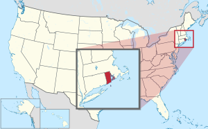
 အမေရိကန်ပြည်ထောင်စု၏ မြေပုံ၊ {{{Name}}} အားအရောင်ခြယ်ပြထား | |||
| နိုင်ငံ | အမေရိကန်ပြည်ထောင်စု | ||
| Before statehood | ရုဒ်အိုင်းလန်းနှင့် ပရိုက်ဗိုက်ဒင့် စိုက်ခင်းများ | ||
| ပြည်ထောင်စုသို့ ဝင်ရောက်ခြင်း | May 29, 1790 (13th) | ||
| မြို့တော် | ပရိုဗိုက်ဒင့်မြို့ | ||
| အကြီးဆုံးမြို့ | မြို့တော် | ||
| အစိုးရ | |||
| • ပြည်နယ်အုပ်ချုပ်ရေးမှူး | Dan McKee (D) | ||
| • လက်ထောက် ပြည်နယ်အုပ်ချုပ်ရေးမှူး | Sabina Matos (D) | ||
| ဧရိယာ[၂] | |||
| • စုစုပေါင်း | ၁,၅၄၅ စတုရန်းမိုင် (၄,၀၀၁ စတုရန်းကီလိုမီတာ) | ||
| • ကုန်းမြေ | ၁,၀၃၄ စတုရန်းမိုင် (၂,၆၇၈ စတုရန်းကီလိုမီတာ) | ||
| • ရေထု | ၅၁၁ စတုရန်းမိုင် (၁,၃၂၄ စတုရန်းကီလိုမီတာ) | ||
| ဧရိယာအဆင့် | 50th | ||
| ထုထည် | |||
| • အလျား | ၄၈ မိုင် (၇၇ ကီလိုမီတာ) | ||
| • အနံ | ၃၇ မိုင် (၆၀ ကီလိုမီတာ) | ||
| ပင်လယ်ရေ မျက်နှာပြင်အမြင့် | ၂၀၀ ပေ (၆၀ မီတာ) | ||
| အမြင့်ဆုံး နေရာ (Jerimoth Hill[၃][မှတ်စု ၁]) | ၈၁၂ ပေ (၂၄၇ မီတာ) | ||
| အနိမ့်ဆုံး နေရာ (Atlantic Ocean[၃]) | ၀ ပေ (၀ မီတာ) | ||
| လူဦးရေ (၂၀၂၀ သန်းခေါင်စာရင်း) | |||
| • စုစုပေါင်း | ၁,၀၉၈,၁၆၃[၄] | ||
| • အဆင့် | 45th | ||
| • သိပ်သည်းမှု | ၁၀၀၆/sq mi (၃၈၈/km၂) | ||
| • သိပ်သည်းမှု အဆင့် | 2nd | ||
| • ပျမ်းမျှ အိမ်ထောင်စု ဝင်ငွေ | $၆၃,၈၇၀[၅] | ||
| • ဝင်ငွေအဆင့် | ၁၅th | ||
| ဘာသာစကား | |||
| • ရုံးသုံးဘာသာစကား | De jure: None De facto: English | ||
| အချိန်ဇုန် | Eastern (UTC– 05:00) | ||
| • နွေရာသီ (DST) | EDT (UTC– 04:00) | ||
| အတိုကောက်များ | RI | ||
| ISO 3166 ကုဒ် | US-RI | ||
| လတ္တီကျူ | 41° 09′ N to 42° 01′ N | ||
| လောင်ဂျီကျူ | 71° 07′ W to 71° 53′ W | ||
| ဝက်ဘ်ဆိုဒ် | ri.gov | ||
ရုဒ်အိုင်းလန်း (အင်္ဂလိပ်: Rhode Island; /ˌroʊd-/ (![]() ))[၆][၇] သည် အမေရိကန်ပြည်ထောင်စု၊ နယူးအင်္ဂလန်ဒေသတွင် တည်ရှိသော ပြည်နယ်တစ်ခု ဖြစ်သည်။ အမေရိကန်ပြည်နယ်များအနက် ဧရိယာအသေးငယ်ဆုံး ပြည်နယ်ဖြစ်ပြီး လူဦးရေးအဆင့် ၁၇ ခုမြောက် ဖြစ်သည်။[၈] ရုဒ်အိုင်းလန်းပြည်နယ်၏ အနောက်ဘက်တွင် ကွန်နက်တီကတ်ပြည်နယ်၊ မြောက်ဘက်နှင့် အရှေ့ဘက်တွင် မက်ဆာချူးဆက်ပြည်နယ်၊ တောင်ဘက်တွင် အတ္တလန္တိတ်သမုဒ္ဒရာတို့ ဝန်းရံလျက်ရှိသည်။[၉] မြို့တော်မှာ ပရိုဗိုက်ဒင့်မြို့ဖြစ်ပြီး ပြည်နယ်၏ အကြီးဆုံးမြို့လည်း ဖြစ်သည်။
))[၆][၇] သည် အမေရိကန်ပြည်ထောင်စု၊ နယူးအင်္ဂလန်ဒေသတွင် တည်ရှိသော ပြည်နယ်တစ်ခု ဖြစ်သည်။ အမေရိကန်ပြည်နယ်များအနက် ဧရိယာအသေးငယ်ဆုံး ပြည်နယ်ဖြစ်ပြီး လူဦးရေးအဆင့် ၁၇ ခုမြောက် ဖြစ်သည်။[၈] ရုဒ်အိုင်းလန်းပြည်နယ်၏ အနောက်ဘက်တွင် ကွန်နက်တီကတ်ပြည်နယ်၊ မြောက်ဘက်နှင့် အရှေ့ဘက်တွင် မက်ဆာချူးဆက်ပြည်နယ်၊ တောင်ဘက်တွင် အတ္တလန္တိတ်သမုဒ္ဒရာတို့ ဝန်းရံလျက်ရှိသည်။[၉] မြို့တော်မှာ ပရိုဗိုက်ဒင့်မြို့ဖြစ်ပြီး ပြည်နယ်၏ အကြီးဆုံးမြို့လည်း ဖြစ်သည်။
ကိုးကား
[ပြင်ဆင်ရန်]- ↑ Rhode Island Government: Government။ RI.gov။ July 1, 2010 တွင် မူရင်းအား မော်ကွန်းတင်ပြီး။ July 31, 2010 တွင် ပြန်စစ်ပြီး။
- ↑ State Area Measurements and Internal Point Coordinates။
- ↑ ၃.၀ ၃.၁ Elevations and Distances in the United States။ United States Geological Survey (2001)။ October 15, 2011 တွင် မူရင်းအား မော်ကွန်းတင်ပြီး။ October 24, 2011 တွင် ပြန်စစ်ပြီး။
- ↑ Bureau၊ US Census (2021-04-26)။ 2020 Census Apportionment Results။ April 26, 2021 တွင် မူရင်းအား မော်ကွန်းတင်ပြီး။ 2021-04-27 တွင် ပြန်စစ်ပြီး။
- ↑ Median Annual Household Income။ December 20, 2016 တွင် မူရင်းအား မော်ကွန်းတင်ပြီး။ December 9, 2016 တွင် ပြန်စစ်ပြီး။
- ↑ Jones၊ Daniel (2003) [1917]၊ Peter Roach; James Hartmann; Jane Setter (eds.)၊ English Pronouncing Dictionary၊ Cambridge: Cambridge University Press၊ ISBN 978-3-12-539683-8
- ↑ Rhode Island။ Merriam-Webster Dictionary။
- ↑ Table 1. Apportionment Population and Number of Representatives by State: 2020 Census (April 26, 2021)။ April 26, 2021 တွင် မူရင်းအား မော်ကွန်းတင်ပြီး။ April 26, 2021 တွင် ပြန်စစ်ပြီး။
- ↑ RG 042/RG 042.03. Rhode Island-New York Boundary, 1942-1944။ Secretary of State။ November 13, 2018 တွင် မူရင်းအား မော်ကွန်းတင်ပြီး။ November 13, 2018 တွင် ပြန်စစ်ပြီး။
| ဤ ဆောင်းပါးမှာ ဆောင်းပါးတိုတစ်ပုဒ် ဖြစ်သည်။ ဖြည့်စွက်ရေးသားခြင်းဖြင့် မြန်မာဝီကီပီးဒီးယားကို ကူညီပါ။ |
ကိုးကား အမှား - <ref> tags exist for a group named "မှတ်စု", but no corresponding <references group="မှတ်စု"/> tag was found


