ဗားမောင့်ပြည်နယ်
ပုံပန်းသွင်ပြင်
| ဗားမောင့်ပြည်နယ် | |||
|---|---|---|---|
| |||
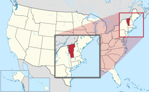
 အမေရိကန်ပြည်ထောင်စု၏ မြေပုံ၊ ဗားမောင့် အားအရောင်ခြယ်ပြထား | |||
| နိုင်ငံ | အမေရိကန်ပြည်ထောင်စု | ||
| Before statehood | Vermont Republic | ||
| ပြည်ထောင်စုသို့ ဝင်ရောက်ခြင်း | March 4, 1791 (14th) | ||
| အကြီးဆုံးမြို့ | Burlington | ||
| အစိုးရ | |||
| • ပြည်နယ်အုပ်ချုပ်ရေးမှူး | Peter Shumlin (D) | ||
| • လက်ထောက် ပြည်နယ်အုပ်ချုပ်ရေးမှူး | Phillip Scott (R) | ||
| လူဦးရေ | |||
| • စုစုပေါင်း | ၆၂၆,၄၃၁ (၂၀၁၁ est) | ||
| • သိပ်သည်းမှု | ၆၇.၇/sq mi (၂၆.၁/km၂) | ||
| • ပျမ်းမျှ အိမ်ထောင်စု ဝင်ငွေ | $၅၂,၁၀၄ | ||
| • ဝင်ငွေအဆင့် | ၂၀th | ||
| ဘာသာစကား | |||
| • ရုံးသုံးဘာသာစကား | English | ||
| လတ္တီကျူ | 42° 44′ N to 45° 1′ N | ||
| လောင်ဂျီကျူ | 71° 28′ W to 73° 26′ W | ||
ဗားမောင့်ပြည်နယ် (အင်္ဂလိပ်: Vermont; /vərˈmɒnt/ (![]() ))[၁] သည် အမေရိကန်ပြည်ထောင်စုရှိ ကုန်းတွင်းပိတ် ပြည်နယ်တစ်ခု ဖြစ်သည်။ တောင်ဘက်တွင် မက်ဆာချူးဆက်ပြည်နယ်၊ အရှေ့ဘက်တွင် နယူးဟမ်ရှိုင်းယားပြည်နယ်၊ အနောက်ဘက်တွင် နယူးယောက်ပြည်နယ်နှင့် မြောက်ဘက်တွင် ကနေဒါနိုင်ငံ ကွီဗက်ပြည်နယ်တို့ ဝန်းရံလျက်ရှိသည်။ ၂၀၂၀ ပြည့်နှစ် သန်းခေါင်စာရင်းအရ ပြည်နယ်လူဦးရေမှာ ၆၄၃,၅၀၃ ဦး ဖြစ်သည်။[၂]
))[၁] သည် အမေရိကန်ပြည်ထောင်စုရှိ ကုန်းတွင်းပိတ် ပြည်နယ်တစ်ခု ဖြစ်သည်။ တောင်ဘက်တွင် မက်ဆာချူးဆက်ပြည်နယ်၊ အရှေ့ဘက်တွင် နယူးဟမ်ရှိုင်းယားပြည်နယ်၊ အနောက်ဘက်တွင် နယူးယောက်ပြည်နယ်နှင့် မြောက်ဘက်တွင် ကနေဒါနိုင်ငံ ကွီဗက်ပြည်နယ်တို့ ဝန်းရံလျက်ရှိသည်။ ၂၀၂၀ ပြည့်နှစ် သန်းခေါင်စာရင်းအရ ပြည်နယ်လူဦးရေမှာ ၆၄၃,၅၀၃ ဦး ဖြစ်သည်။[၂]
ကိုးကား
[ပြင်ဆင်ရန်]- ↑ "Vermont"၊ Oxford English Dictionary (3rd ed.)၊ Oxford University Press၊ September 2005 မရေရာသော
|mode=CS1(အကူအညီ) (Subscription or UK public library membership required.) - ↑ 2020 Census Apportionment Results။ United States Census Bureau။ April 26, 2021 တွင် မူရင်းအား မော်ကွန်းတင်ပြီး။ April 30, 2021 တွင် ပြန်စစ်ပြီး။
| ဤ ဆောင်းပါးမှာ ဆောင်းပါးတိုတစ်ပုဒ် ဖြစ်သည်။ ဖြည့်စွက်ရေးသားခြင်းဖြင့် မြန်မာဝီကီပီးဒီးယားကို ကူညီပါ။ |


