ဟူနန်ပြည်နယ်
ဟူနန်ပြည်နယ်(တရုတ်: 湖南省; ပင်ယင်: Húnán Shěng)သည် တရုတ်ပြည်သူ့သမ္မတနိုင်ငံ တောင်ဘက်ရှိ ပြည်နယ်ဖြစ်သည်။ အမည်မှာ ဒုံထင်ဟို(洞庭湖) တောင်ဘက်ဟူသည့် ဝေါဟာရမှ ဆင်းသက်လာသည်။ မြောက်ဘက်၌ ဟူဘေပြည်နယ်၊ အရှေ့ဘက်၌ ကျံဆီပြည်နယ်၊ တောင်ဘက်၌ ဂိုအံဒုံပြည်နယ်၊ အနောက်တောင်ဘက်တွင် Guangxi Zhuang ကိုယ်ပိုင်အုပ်ချုပ်ခွင့်ရဒေသ၊ အနောက်ဘက်တွင် Guizhou ပြည်နယ်နှင့် အနောက်မြောက်ဘက်တွင် Chongqingတို့ဖြင့် ထိစပ်နေသည်။
ရာဇဝင်
[ပြင်ဆင်ရန်]Hunan's primeval forests were first occupied by the ancestors of the modern Miao, Tujia, Dong and Yao peoples. It entered the written history of China around 350 BC, when under the kings of the Zhou dynasty, it became part of the State of Chu. At this time, and for hundreds of years thereafter, it was a magnet for migration of Han Chinese from the north, who cleared most of the forests and began farming rice in the valleys and plains. To this day many of the small villages in Hunan are named after the Han families who settled there. Migration from the north was especially prevalent during the Eastern Jin Dynasty and the Southern and Northern Dynasties Periods, when nomadic invaders pushed these peoples south.
During the Five Dynasties and Ten Kingdoms Period, Hunan was home to its own independent regime, Ma Chu.
ဟူနန်နှင့်ဟူပေသည် ချင်မင်းဆက်လက်ထက်တိုင်အောင် ဟူကွမ်ပြည်နယ်(湖廣)တွင်ပါဝင်သည်။ ၁၆၆၄ခုနှစ်တွင် ဟူနန်ပြည်နယ်ကိုဖွဲ့စည်းပြီး ဟူကွမ်ပြည်နယ်မှခွဲထုတ်ခဲ့သည်။ ၁၇၂၃ တွင်လက်ရှိအမည်ကိုရရှိခဲ့သည်။

Hunan became an important communications center due to its position on the Yangzi River (Changjiang). It was also on the Imperial Highway constructed between northern and southern China. The land produced grain so abundantly that it fed many parts of China with its surpluses. The population continued to climb until, by the nineteenth century, Hunan became overcrowded and prone to peasant uprisings. Some of the uprisings were caused by ethnic tensions like ten-years long Miao people rebellion of 1795-1806.
ထိုက်ဖျင်အရေးတော်ပုံသည် တောင်ဖက်ရှိ ကွမ်ရှီးပြည်နယ်တွင် ၁၈၅၀ ၌ စတင်ခဲ့ပြီး ဟူနန်ပြည်နယ်သို့ကူးစက်လာခဲ့သည်။ ထို့နောက်ယန်စီမြစ်ဝှမ်းတစ်လျှောက်ပြန့်နှံ့သွားခဲ့သည်။ Ultimately, it was a Hunanese army under Zeng Guofan who marched into Nanjing to put down the uprising in 1864.
Hunan was relatively quiet until 1910 when there were uprisings against the crumbling Qing dynasty, which were followed by the Communist's Autumn Harvest Uprising of 1927. It was led by Hunanese native Mao Zedong, and established a short-lived Hunan Soviet in 1927. The Communists maintained a guerrilla army in the mountains along the Hunan-Jiangxi border until 1934. Under pressure from the Nationalist Kuomintang (KMT) forces, they began the famous Long March to bases in Shaanxi Province. After the departure of the Communists, the KMT army fought against the Japanese in the second Sino-Japanese war. They defended the capital Changsha until it fell in 1944. Japan launched Operation Ichigo, a plan to control the railroad from Wuchang to Guangzhou (Yuehan Railway). Hunan was relatively unscathed by the civil war that followed the defeat of the Japanese in 1945. In 1949, the Communists returned once more as the Nationalists retreated southward.
မော်စီတုံးမွေးရာဇာတိပြည်နယ်အဖြစ် ဟူနနန်ပြည်နယ်သည် ၁၉၆၆-၁၉၇၆ယဉ်ကျေးမှုတော်လှန်ရေးတွင်ထောက်ခံခဲ့သည်။ However it was slower than most provinces in adopting the reforms implemented by Deng Xiaoping in the years that followed Mao's death in 1976.
ယခင်ဝန်ကြီးချုပ်ဟောင်း ကျူရုံကျိ၊ သမ္မတဟောင်း လျှိုလျှောက်ချီ၊ ဗိုလ်ချုပ်ကြီးဟောင်း ဖုန်တယ်ဟွေးတို့သည် ဟူနန်နယ်သားများဖြစ်ကြသည်။
ပထဝီအနေအထား
[ပြင်ဆင်ရန်]Hunan is located on the south bank of the Yangtze River, about half way along its length, situated between 108° 47'-114° 16' east longitude and 24° 37'-30° 08' north latitude. It covers an area of ၂၁၁,၈၀၀ စတုရန်း ကီလိုမီတာ (၈၁,၈၀၀ စတုရန်းမိုင်), making it the 10th largest provincial-level division. The east, south and west sides of the province are surrounded by mountains and hills, such as the Wuling Mountains to the northwest, the Xuefeng Mountains to the west, the Nanling Mountains to the south, and the Luoxiao Mountains to the east. The mountains and hills occupy more than 80% of the area and plains comprises less than 20% of the whole province.
The Xiang, the Zi, the Yuan and the Lishui Rivers converge on the Yangtze River at Lake Dongting in the north of Hunan. The center and northern parts are somewhat low and a U-shaped basin, open in the north and with Lake Dongting as its center. Most of Hunan Province lies in the basins of four major tributaries of the Yangtze River.
တုန့်ထင်အိုင်သည် ပြည်နယ်အတွင်းအကြီးဆုံးအိုင်ဖြစ်ပြီးတရုတ်နိုင်ငံတွင်ဒုတိယအကြီးဆုံးရေချိုအိုင်ကြီးဖြစ်သည်။ Due to the reclamation of land for agriculture, Lake Dongting has been subdivided into many smaller lakes, though there is now a trend to reverse some of the reclamation, which had damaged wetland habitats surrounding the lake.
Hunan's climate is subtropical, and, under the Köppen climate classification, is classified as being humid subtropical (Köppen Cfa), with short, cool, damp winters, very hot and humid summers, and plenty of rainfall. January temperatures average ၃ to ၈ ဒီဂရီ စင်တီဂရိတ် (၃၇ to ၄၆ ဒီဂရီ ဖာရင်ဟိုက်) while July temperatures average around ၂၇ to ၃၀ ဒီဂရီ စင်တီဂရိတ် (၈၁ to ၈၆ ဒီဂရီ ဖာရင်ဟိုက်). Average annual precipitation is ၁,၂၀၀ to ၁,၇၀၀ မီလီမီတာ (၄၇ to ၆၇ လက်မ).
အုပ်ချုပ်ရေးနှင့်တိုင်းခွဲများ
[ပြင်ဆင်ရန်]

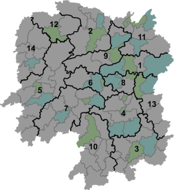
Hunan is divided into 14 prefecture-level divisions, of which 13 are prefecture-level cities and the remaining division an autonomous prefecture. The prefecture-level cities are:
| Map | # | Name | Administrative Seat | Hanzi Hanyu Pinyin |
Population (2010) |
|---|---|---|---|---|---|

| |||||
| — Prefecture-level city — | |||||
| 1 | Changsha | Tianxin District | 长沙市 Chángshā Shì |
7,044,118 | |
| 2 | Changde | Wuling District | 常德市 Chángdé Shì |
5,747,218 | |
| 3 | Chenzhou | Beihu District | 郴州市 Chénzhōu Shì |
4,581,778 | |
| 4 | Hengyang | Yanfeng District | 衡阳市 Héngyáng Shì |
7,141,462 | |
| 5 | Huaihua | Hecheng District | 怀化市 Huáihuà Shì |
4,741,948 | |
| 6 | Loudi | Louxing District | 娄底市 Lóudǐ Shì |
3,785,627 | |
| 7 | Shaoyang | Shuangqing District | 邵阳市 Shàoyáng Shì |
7,071,826 | |
| 8 | Xiangtan | Yuetang District | 湘潭市 Xiāngtán Shì |
2,748,552 | |
| 9 | Yiyang | Heshan District | 益阳市 Yìyáng Shì |
4,313,084 | |
| 10 | Yongzhou | Lengshuitan District | 永州市 Yǒngzhōu Shì |
5,180,235 | |
| 11 | Yueyang | Yueyanglou District | 岳阳市 Yuèyáng Shì |
5,477,911 | |
| 12 | Zhangjiajie | Yongding District | 张家界市 Zhāngjiājiè Shì |
1,476,521 | |
| 13 | Zhuzhou | Tianyuan District | 株洲市 Zhūzhōu Shì |
3,855,609 | |
| — Autonomous prefecture — | |||||
| 14 | Xiangxi (for Tujia and Miao) |
Jishou | 湘西土家族苗族自治州 Xiāngxī Tǔjiāzú Miáozú Zìzhìzhōu |
2,547,833 | |
The fourteen prefecture-level divisions of Hunan are subdivided into 122 county-level divisions (34 districts, sixteen county-level cities, 65 counties, seven autonomous counties). Those are in turn divided into 2587 township-level divisions (1098 towns, 1158 townships, 98 ethnic townships, 225 subdistricts, and eight district public offices).
Politics
[ပြင်ဆင်ရန်]The Politics of Hunan is structured in a dual party-government system like all other governing institutions in mainland China.
The Governor of Hunan is the highest-ranking official in the People's Government of Hunan. However, in the province's dual party-government governing system, the Governor has less power than the Hunan Communist Party of China Provincial Committee Secretary, colloquially termed the "Hunan CPC Party Chief".
စီးပွားရေး
[ပြင်ဆင်ရန်]ဟူနန်ပြည်နယ်၏ အဓိကစိုက်ပျိုးသီးနှံမှာ စပါးနှင့်ဝါဂွမ်းဖြစ်သည်။ တုန့်ထင်အိုင်ပတ်ဝန်းကျင်သည် Hunan's traditional crops are rice and cotton. The Lake Dongting area is an important center of ramie production, and Hunan is also an important center of tea cultivation. Aside from agricultural products, in recent years Hunan has grown to become an important center for steel, machinary and electronics production, especially as China's manufacturing sector moves away from coastal provinces such as Guangdong and Zhejiang.[၁]
The Lengshuijiang area is noted for its stibnite mines, and is one of the major centers of antimony extraction in China.
Its nominal GDP for 2011 was 1.90 trillion yuan (US$300 billion). Its per capita GDP was 20,226 yuan (US$2,961).[၂]
Economic and technological development zones
[ပြင်ဆင်ရန်]- Changsha National Economic and Technical Development Zone
The Changsha National Economic and Technology Development Zone was founded in 1992. It is located east of Changsha. The total planned area is 38.6 km2 and the current area is 14 km2. Near the zone is National Highways G319 and G107 as well as Jingzhu Highway. Besides that, it is very close to the downtown and the railway station. The distance between the zone and the airport is 8 km. The major industries in the zone include high-tech industry, biology project technology and new material industry.[၃]
- Changsha National New & Hi-Tech Industrial Development Zone
- Chenzhou Export Processing Zone
Approved by the State Council, Chenzhou Export processing Zone (CEPZ) was established in 2005 and is the only export processing zone in Hunan province. The scheduled production area of CEPZ covers 3km2. The industrial positioning of CEPZ is to concentrate on developing export-oriented hi-tech industries, including electronic information, precision machinery, and new-type materials. The zone has good infrastructure, and the enterprises inside could enjoy the preferential policies of tax-exemption, tax-guarantee and tax-refunding. By the end of the “Eleventh Five-Year Plan”, the CEPZ achieved a total export and import volume of over USD 1 billion and provided more than 50,000 jobs. It aimed to be one of the first-class export processing zones in China.[၄]
- Zhuzhou National New & Hi-Tech Industrial Development Zone
Zhuzhou Hi-Tech Industrial Development Zone was founded in 1992. Its total planned area is 35 km2. It is very close to National Highway G320. The major industries in the zone include biotechnology, food processing and heavy industry. In 2007, the park signed a cooperation contract with Beijing Automobile Industry, one of the largest auto makers in China, which will set up a manufacturing base in Zhuzhou HTP.[၅]
Artistic
[ပြင်ဆင်ရန်]The Hunan Province is accredited with being filled with skilled craftsmen and women who create embroidered silks, carved jade, and other skillfully hand made artistic goods of international quality.
လူဦးရေ
[ပြင်ဆင်ရန်]၂၀၀၀ ခုနှစ်သန်းခေါင်စာရင်းအရ ဟူနန်ပြည်နယ်၏လူဦးရေသည် ၆၄,၄၀၀,၇၀၀ ဦးရှိပြီး တိုင်းရင်းသား၄၁မျိုးနေထိုင်ကြသည်။ ၁၉၉၀ နှစ်များနှင့်ယှဉ်ပါက ၆.၁၇%(၃,၇၄၂,၇၀၀ဦး)တိုးတက်လာသည်။ ယင်းအနက်မှ ၈၉.၇၉%(၅၇,၅၄၀,၀၀၀ဦး)မှာ ဟန်(တရုတ်)လူမျိုးများဖြစ်ကြပြီး ၁၀.၂၁%(၆,၅၇၅,၃၀၀ဦး) မှာလူနည်းစုတိုင်းရင်းသားများဖြစ်ကြသည်။
ကိုးကား
[ပြင်ဆင်ရန်]- ↑ မော်ကွန်းတင်ပြီးမိတ္တူ။ 8 October 2011 တွင် မူရင်းအား မော်ကွန်းတင်ပြီး။ 9 January 2013 တွင် ပြန်စစ်ပြီး။
- ↑ 宁夏回族自治区2010年第六次全国人口普查主要数据公报
- ↑ RightSite.asia | Changsha National Economic and Technology Development Zone။ 26 August 2011 တွင် မူရင်းအား မော်ကွန်းတင်ပြီး။ 9 January 2013 တွင် ပြန်စစ်ပြီး။
- ↑ RightSite.asia | Chenzhou Export Processing Zone။ 26 August 2011 တွင် မူရင်းအား မော်ကွန်းတင်ပြီး။ 9 January 2013 တွင် ပြန်စစ်ပြီး။
- ↑ RightSite.asia | Zhuzhou Hi-Tech Industrial Development Zone။ 24 February 2016 တွင် မူရင်းအား မော်ကွန်းတင်ပြီး။ 9 January 2013 တွင် ပြန်စစ်ပြီး။
