ဘုရာ့နခွန်ခရိုင်
ပုံပန်းသွင်ပြင်
ဤ ဆောင်းပါးသည် အခြားဘာသာစကားမှ မူကြမ်းသဘောမျိုး ဘာသာပြန်ထားသော ဆောင်းပါးဖြစ်သည်။ ပါဝင်သောအကြောင်းအရာများမှာ ဘာသာနှစ်ခုလုံးကို ကျွမ်းကျင်မှုမရှိသော ကွန်ပျူတာ သို့မဟုတ် ဘာသာပြန်ဆော့ဝဲလ် တမျိုးမျိုးအသုံးပြု၍ ရရှိလာသော အကြောင်းအရာများဖြစ်သည်။ ပြည့်စုံကြွယ်ဝသော ဘာသာပြန်မှုဖြစ်စေရန် ကူညီနိုင်ပါသည်။ |
| Phra Nakhon พระนคร | |
|---|---|
| Khet | |
 | |
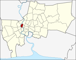
 District location in Bangkok | |
| ကိုဩဒိနိတ်: 13°45′52″N 100°29′57″E / 13.76444°N 100.49917°Eကိုဩဒိနိတ်: 13°45′52″N 100°29′57″E / 13.76444°N 100.49917°E | |
| Country | Thailand |
| Province | Bangkok |
| Seat | Wat Sam Phraya |
| Khwaeng | 12 |
| ဧရိယာ | |
| • စုစုပေါင်း | ၅.၅၃၆ စတုရန်းကီလိုမီတာ (၂.၁၃၇ စတုရန်းမိုင်) |
| လူဦးရေ (2017) | |
| • စုစုပေါင်း | ၅၁၂၃၁[၁] |
| • သိပ်သည်းမှု | ၉၂၅၄.၁၅/km၂ (၂၃၉၆၈.၁/sq mi) |
| အချိန်ဇုန် | ICT (UTC+7) |
| Postal code | 10200 |
| Geocode | 1001 |

ဘုရာ့နခွန် ( ထိုင်း: พระนคร အသံထွက် [pʰráʔ ná(ʔ).kʰɔ̄ːn] ) ကိုတဈဦးဖွဈသညျ 50 ခရိုင် ၏ (ခက်) ဘန်ကောက်, ထိုင်းနိုင်ငံ ။ ဒါဟာ Rattanakosin ကျွန်း အပါအဝင်ဘန်ကောက်၏ဗဟိုခရိုင်ဖြစ်ပါတယ်။ အနီးအနားရှိခရိုင်များသည်မြောက်ဘက်မှနာရီလက်တံ ပတ်လုံး ဖြစ်သော Dusit ၊ Pom Prap Sattru Phai ၊ Samphanthawong နှင့် Chao Phraya မြစ် တစ်လျှောက်၊ Thon Buri, Bangkok Yai, Bangkok Noi နှင့် Bang Phlat တို့ဖြစ်သည်။
- ↑ Population and House Report for Year 2017။ Department of Provincial Administration, Ministry of Internal Affairs။ 2018-04-01 တွင် ပြန်စစ်ပြီး။ (Search page)
