တြိပူရပြည်နယ်
ပုံပန်းသွင်ပြင်
| တြိပူရပြည်နယ် | ||
|---|---|---|
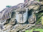
(clockwise from top) Ujjayanta Palace; Rock-cut sculptures at Unakoti; Tripura Sundari Temple; Wildlife of Sepahijala; Neermahal palace; Tripura Legislative Assembly | ||
| ||
| ဆောင်ပုဒ်: Satyameva Jayate (Sanskrit) (English: "Truth alone triumphs") | ||
 | ||
| Country | ||
| Union territory | 1 November 1956 | |
| Upgraded as state | 21 January 1972† | |
| အမည်ပေး | Tripura Sundari Temple | |
| Capital and largest city | Agartala | |
| Districts | 8 | |
| အစိုးရ | ||
| • အစိုးရအဖွဲ့ | Government of Tripura | |
| • Governor | Satyadev Narayan Arya[၁] | |
| • Chief Minister | Manik Saha | |
| ဧရိယာ[၂] | ||
| • စုစုပေါင်း | ၁၀၄၉၁.၆၉ စတုရန်းကီလိုမီတာ (၄၀၅၀.၈၆ စတုရန်းမိုင်) | |
| ဧရိယာအဆင့် | 28th of 36 | |
| လူဦးရေ (2011) | ||
| • စုစုပေါင်း | ၃၆၇၁၀၃၂ | |
| • ခန့်မှန်း (2022)[၃] | ၄၁၀၉၀၀၀ | |
| • သိပ်သည်းမှု | ၃၅၀/km၂ (၉၁၀/sq mi) | |
| GDP (2020–21) | ||
| • Nominal | {{{demographics1_info1}}} | |
| အချိန်ဇုန် | IST (UTC+05:30) | |
| ISO 3166 ကုဒ် | IN-TR | |
| ယာဉ်မှတ်ပုံတင် | TR- | |
| HDI (2022) | medium[၄] | |
| Official languages[၅] | ||
| ဝက်ဘ်ဆိုဒ် | tripura.gov.in | |
| †It was elevated from the status of Union territory by the North-Eastern Areas (Reorganisation) Act 1971 | ||
တြိပူရ ( /ˈtrɪpʊrə, -ərə/ ၊/ˈtrɪpʊrə, -ərə/, ဘင်္ဂါလီ: [ˈtri̯puraˈ]) [၆] သည် အိန္ဒိယနိုင်ငံ အရှေ့မြောက်ပိုင်းရှိ ပြည်နယ်တစ်ခုဖြစ်သည်။ နိုင်ငံ၏ တတိယအသေးငယ်ဆုံးပြည်နယ်၊ ၎င်းသည် ၁၀,၄၉၁ စတုရန်း ကီလိုမီတာ (၄,၀၅၁ စတုရန်းမိုင်) ခုရှိသည်။ လူဦးရေ ၃၆.၇၁ သိန်း (၃.၆၇ သန်း) ရှိသည့် သတ္တမမြောက် လူဦးရေအနည်းဆုံး ပြည်နယ်ဖြစ်သည်။ [၇] အရှေ့ဘက်တွင် အာသံနှင့် မီဇိုရမ်ပြည်နယ်၊ မြောက်၊ တောင်နှင့် အနောက်ဘက်တွင် ဘင်္ဂလားဒေ့ရှ်နိုင်ငံတို့ နှင့် နယ်နိမိတ်ချင်း ထိစပ်နေသည်။ [၈] တြိပူရကို ခရိုင် ၈ ခု နှင့် အပိုင်းခွဲ ၂၃ ခုခွဲ၍ Agartala သည် မြို့တော်ဖြစ်ပြီး ပြည်နယ်၏ အကြီးဆုံးမြို့ဖြစ်သည်။ တြိပူရတွင် ဘင်္ဂလီ လူမျိုး အများစုနေထိုင်သော လူမျိုးစု [၉] မျိုးရှိသည်။ ဘင်္ဂါလီ၊ အင်္ဂလိပ်နှင့် ကိုးဘောက်တို့သည် ပြည်နယ်၏ ရုံးသုံး ဘာသာစကားများ ဖြစ်သည်။
ကိုးကား
[ပြင်ဆင်ရန်]- ↑ Shri Satyadeo Narain Arya Hon'ble Governor of Tripura။ 3 March 2022 တွင် ပြန်စစ်ပြီး။
- ↑ Know Tripura | Tripura State Portal။ 23 December 2020 တွင် ပြန်စစ်ပြီး။
- ↑ https://uidai.gov.in/images/StateWiseAge_AadhaarSat_Rep_31082022_Projected-2022-Final.pdf
- ↑ Sub-national HDI – Area Database (in en)။ Institute for Management Research, Radboud University။ 23 September 2018 တွင် မူရင်းအား မော်ကွန်းတင်ပြီး။ 25 September 2018 တွင် ပြန်စစ်ပြီး။
- ↑ Report of the Commissioner for linguistic minorities: 52nd report (July 2014 to June 2015) 79–84။ Commissioner for Linguistic Minorities, Ministry of Minority Affairs, Government of India။ 15 November 2016 တွင် မူရင်းအား မော်ကွန်းတင်ပြီး။ 16 February 2016 တွင် ပြန်စစ်ပြီး။
- ↑ Longman Pronunciation Dictionary။ 2008။
- ↑ Tripura - History, Map, Population, & Facts။ 22 January 2022 တွင် ပြန်စစ်ပြီး။
- ↑ Rohingya crisis: Security tightened along India-Myanmar border။ 15 September 2017 တွင် မူရင်းအား မော်ကွန်းတင်ပြီး။
- ↑ You must specify archiveurl = and archivedate = when using {{cite web}}.people | Tripura Tribal Areas Autonomous District Council။ 2022-12-23 တွင် မူရင်းအား မော်ကွန်းတင်ပြီး။


