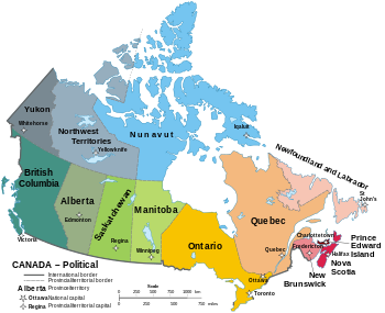
ကနေဒါနိုင်ငံရှိ ပြည်နယ်များနှင့် နယ်မြေများ
| ကနေဒါနိုင်ငံရှိ ပြည်နယ်များနှင့် နယ်မြေများ | |
|---|---|
 | |
| အမျိုးအစား | Federated state |
| အရေအတွက် | ၁၀ပြည်နယ် နယ်မြေ၃ခု |
ကနေဒါနိုင်ငံရှိ ပြည်နယ်များနှင့်နယ်မြေများ၏ ပထဝီဒေသများအတွင်း အမျိုးသားရေးကွဲပြားမှုရှိသည်။ ကနေဒါဖွဲ့စည်းပုံအခြေခံဥပဒေအရ ကနေဒါ ၏ တရားစီရင်ပိုင်ခွင့်အောက်တွင် တည်ရှိသည်။ ၁၈၆၇ ခုနှစ်တွင် ကနေဒါကွန်ဖက်ဒရေးရှင်းတွင် ဗြိတိသျှမြောက်အမေရိက၏ ပြည်နယ်သုံးခုဖြစ်သည့် နယူးဘရွန်းရှစ်၊ နယူးစတီးယား နှင့် ကနေဒါ (ကွန်ဖက်ဒရေးရှင်းအနေဖြင့် အွန်တိုရီယို နှင့် ကွီဗက်ပြည်နယ် ဘက်သို့ ခွဲခြားထားသော) ပြည်နယ် ၃ ခုသည် စုစည်း၍ ကိုလိုနီအဖြစ်ဖွဲ့စည်းကာ အချုပ်အခြာအာဏာပိုင်နိုင်ငံတစ်နိုင်ငံ ဖြစ်လာခဲ့သည်။ ၎င်း၏သမိုင်းကြောင်းအရ ကနေဒါနိုင်ငံ၏ အပြည်ပြည်ဆိုင်ရာနယ်နိမိတ်သည် အကြိမ်ပေါင်းများစွ ာပြောင်းလဲခဲ့ပြီး တိုင်းပြည်သည် မူရင်းပြည်နယ် ၄ ခုမှ လက်ရှိပြည်နယ် ၁၀ ခုနှင့်နယ်မြေ ၃ ခုသို့ တိုးတက်ခဲ့သည်။ ပြည်နယ်များနှင့် နယ်မြေများသည် စုစုပေါင်းအကျယ်အဝန်းအားဖြင့် ကမ္ဘာ့ဒုတိယအကြီးဆုံးနိုင်ငံ ဖြစ်သည်။
ပြည်နယ်များ
[ပြင်ဆင်ရန်]| တံဆိပ် | ပြည်နယ် | အတိုကောက်စာလုံး | မြို့တော် |
အကြီးဆုံး မြို့ [၁] |
Entered Confederation[၂] |
Population [မှတ်စု ၁] |
Area (km2)[၄] | Official language(s)[၅] |
Seats[၆] | |||
|---|---|---|---|---|---|---|---|---|---|---|---|---|
| Land | Water | Total | Commons | Senate | ||||||||
| ON | Toronto | ၁ ဇူလိုင် ၁၈၆၇ | 14,734,014 | 917,741 | 158,654 | 1,076,395 | English[မှတ်စု ၃] | 121 | 24 | |||
| QC | Quebec City | Montreal | ၁ ဇူလိုင် ၁၈၆၇ | 8,574,571 | 1,356,128 | 185,928 | 1,542,056 | French[မှတ်စု ၄] | 78 | 24 | ||
| NS | Halifax[မှတ်စု ၅] | ၁ ဇူလိုင် ၁၈၆၇ | 979,351 | 53,338 | 1,946 | 55,284 | English[မှတ်စု ၆] | 11 | 10 | |||
| NB | Fredericton | Moncton | ၁ ဇူလိုင် ၁၈၆၇ | 781,476 | 71,450 | 1,458 | 72,908 | English French[မှတ်စု ၇] |
10 | 10 | ||
| MB | Winnipeg | ၁၅ ဇူလိုင် ၁၈၇၀ | 1,379,263 | 553,556 | 94,241 | 647,797 | Englishကိုးကား အမှား - Invalid <ref> tag; refs with no name must have content[မှတ်စု ၈]
|
14 | 6 | |||
| BC | Victoria | Vancouver | ၂၀ ဇူလိုင် ၁၈၇၁ | 5,147,712 | 925,186 | 19,549 | 944,735 | Englishကိုးကား အမှား - Invalid <ref> tag; refs with no name must have content
|
42 | 6 | ||
| PE | Charlottetown | ၁ ဇူလိုင် ၁၈၇၃ | 159,625 | 5,660 | 0 | 5,660 | Englishကိုးကား အမှား - Invalid <ref> tag; refs with no name must have content
|
4 | 4 | |||
| SK | Regina | Saskatoon | ၁ စက်တင်ဘာ ၁၉၀၅ | 1,178,681 | 591,670 | 59,366 | 651,036 | Englishကိုးကား အမှား - Invalid <ref> tag; refs with no name must have content
|
14 | 6 | ||
| AB | Edmonton | Calgary | ၁ စက်တင်ဘာ ၁၉၀၅ | 4,421,876 | 642,317 | 19,531 | 661,848 | Englishကိုးကား အမှား - Invalid <ref> tag; refs with no name must have content
|
34 | 6 | ||
| NL | St. John's | ၃၁ မတ် ၁၉၄၉ | 522,103 | 373,872 | 31,340 | 405,212 | Englishကိုးကား အမှား - Invalid <ref> tag; refs with no name must have content
|
7 | 6 | |||
| Total provinces | 37878672 | 5490918 | 572013 | 6062931 | — | 335 | 102 | |||||
- ↑ As of Q3 2020.[၃]
- ↑ Ottawa, the national capital of Canada, is located in Ontario, near its border with Quebec. However, the National Capital Region straddles the border.
- ↑ De facto; French has limited constitutional status.
- ↑ Charter of the French Language; English has limited constitutional status.
- ↑ Nova Scotia dissolved cities in 1996 in favour of regional municipalities; its largest regional municipality is therefore substituted.
- ↑ Nova Scotia has very few bilingual statutes (three in English and French; one in English and Polish); some Government bodies have legislated names in both English and French.
- ↑ Section Sixteen of the Canadian Charter of Rights and Freedoms.
- ↑ Although the province has above average constitutional protections for the French language it is still not an official language .
နယ်မြေဒေသဆိုင်ရာဆင့်ကဲဖြစ်စဉ်
[ပြင်ဆင်ရန်]တမ်းပလိတ်:Current provincial governments in Canada
- ↑ Place name (2013)။ Census Profile။ Statistic Canada။ August 6, 2013 တွင် ပြန်စစ်ပြီး။
- ↑ Reader's Digest Association (Canada) (2004)။ The Canadian Atlas: Our Nation, Environment and People။ Douglas & McIntyre။ November 21, 2015 တွင် ပြန်စစ်ပြီး။
- ↑ Population estimates, quarterly။ Statistics Canada (March 20, 2020)။ 3 July 2020 တွင် မူရင်းအား မော်ကွန်းတင်ပြီး။ March 20, 2020 တွင် ပြန်စစ်ပြီး။
- ↑ Land and freshwater area, by province and territory။ Statistics Canada (2005)။ 24 May 2011 တွင် မူရင်းအား မော်ကွန်းတင်ပြီး။ August 4, 2013 တွင် ပြန်စစ်ပြီး။
- ↑ Coche (2012)။ Official Language Policies of the Canadian Provinces။ Fraser Institute။ 28 April 2012 တွင် မူရင်းအား မော်ကွန်းတင်ပြီး။ August 6, 2012 တွင် ပြန်စစ်ပြီး။
- ↑ Guide to the Canadian House of Commons။ Parliament of Canada (2012)။ 7 January 2019 တွင် မူရင်းအား မော်ကွန်းတင်ပြီး။ August 6, 2013 တွင် ပြန်စစ်ပြီး။
