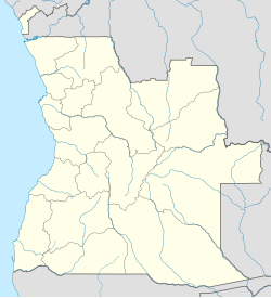
ကာကွန်ဂိုမြို့
| ကာကွန်ဂိုမြို့ | |
|---|---|
| မြို့ | |
| အင်ဂိုလာနိုင်ငံရှိ တည်နေရာ | |
| ကိုဩဒိနိတ်: 05°14′S 12°08′E / 5.233°S 12.133°Eကိုဩဒိနိတ်: 05°14′S 12°08′E / 5.233°S 12.133°E | |
| နိုင်ငံ | |
| ပြည်နယ် | ကာဘင်ဒါ |
| လူဦးရေ (၂၀၁၄ ခုနှစ် သန်းခေါင်စာရင်း) | |
| • စုစုပေါင်း | ၁၅၀၀၀ |
| အချိန်ဇုန် | WAT (UTC+1) |
| ရာသီဥတု | Aw |
ကာကွန်ဂိုမြို့[၁](Guilherme Capelo[၂] or Lândana[၃])သည် အင်ဂိုလာနိုင်ငံ၊ ကာဘင်ဒါပြည်နယ်၊ ကာကွန်ဂိုမြူနီစပါယ်ဒေသတွင် တည်ရှိပြီး လူဦးရေ ၁၅,၀၀၀(၂၀၁၄)[၄] နေထိုင်ကြသည်။[၅][၆] ယခင်က လန်ဒါနာမြူနီစပါယ်ဒေသာကို ကာကွန်ဂိုဟုပြောင်းလဲလည်းခေါ်ဝေါ်ခဲ့ခြင်းဖြစ်သောကြောင့် တခါတရံတွင် မြို့ကို လန်ဒါနာဟု သုံးနှုန်းကြသေးသည်။[၇] မြို့သည် ချီလွန်းဂိုမြစ်ဝမှ တစ်ကီလိုမီတာခန်အကွာ လန်ဒါနာပင်လယ်အော်တွင် တည်ရှိသည်။[၈]
သမိုင်း
[ပြင်ဆင်ရန်]၁၅ ရာစု ပေါ်တူဂီတို့ ရောက်ရှိလာသောအချိန်တွင် ကျေးရွာတစ်ခုဖြစ်ပြီး ကွန်ဂိုလူမျိုးများ နေထိုင်ကြပြီး ကာကွန်ဂိုဘုရင့်နိုင်ငံ၏ အစိတ်အပိုင်းတစ်ခုဖြစ်သည်။ ပေါ်တူဂီ၊ ဒတ်ချ်၊ ဗြိတိသျှနှင့် ပြင်သစ်တို့သည် ကမ်းရိုးတန်းတစ်လျှောက်၌ ကုန်သွယ်မှုများ ပြုလုပ်ခဲ့ကြသော်လည်း ၁၈၈၃ ခုနှစ်တွင် ဒေသခံဘုရင်နှင့် ချုပ်ဆိုသော စာချုပ်အရ ပေါ်တူဂီတို့မှ မြို့အား သိမ်းပိုက်ခဲ့ကြသည်။[၉]
ကိုးကား
[ပြင်ဆင်ရန်]- ↑ Cacongo (Approved) at GEOnet Names Server, United States National Geospatial-Intelligence Agency
- ↑ Guilherme Capelo (Variant) at GEOnet Names Server, United States National Geospatial-Intelligence Agency
- ↑ Lândana (Variant) at GEOnet Names Server, United States National Geospatial-Intelligence Agency
- ↑ Citypopulation.de Population of cities & urban localities in Angola
- ↑ City councils of Angola။ Statoids။ 7 April 2009 တွင် ပြန်စစ်ပြီး။
- ↑ Reference Center: Provinces။ Angolan Embassy in the United States။ 11 February 2006 တွင် မူရင်းအား မော်ကွန်းတင်ပြီး။ 22 July 2021 တွင် ပြန်စစ်ပြီး။
- ↑ GeoNames Search Archived 18 March 2017 at the Wayback Machine.: "Angola: Cabinda: Cacongo", United States National Geospatial-Intelligence Agency
- ↑ United States. Hydrographic Office (1916) Africa Pilot: The southwest coast of Africa from Cape Palmas to the Cape of Good Hope, including the islands of St. Helena, Ascension, Tristan da Cunha, and neighboring islands Hydrographic Office, Washington, D.C., volume 1, page 346 OCLC 62355097
- ↑ Rawson, Rawson W. (November 1884) "The Territorial Partition of the Coast of Africa" Proceedings of the Royal Geographical Society and monthly record of geography, Volume 6, No. XI, pages 615–631, page 623
| ဤ အင်ဂိုလာနိုင်ငံ၏ တည်နေရာ ဆောင်းပါးမှာ ဆောင်းပါးတိုတစ်ပုဒ် ဖြစ်သည်။ ဖြည့်စွက်ရေးသားခြင်းဖြင့် မြန်မာဝီကီပီးဒီးယားကို ကူညီပါ။ |

