
ဖိုင်:France OlympusMons Size.svg

Size of this PNG preview of this SVG file: ၅၀၀ × ၅၀၀ ပစ်ဇယ်. အခြား ပုံရိပ်ပြတ်သားမှု: ၂၄၀ × ၂၄၀ ပစ်ဇယ် | ၄၈၀ × ၄၈၀ ပစ်ဇယ် | ၇၆၈ × ၇၆၈ ပစ်ဇယ် | ၁၀၂၄ × ၁၀၂၄ ပစ်ဇယ် | ၂၀၄၈ × ၂၀၄၈ ပစ်ဇယ်။
မူရင်းဖိုင် (SVG ဖိုင်, ၅၀၀ × ၅၀၀ pixels ကို အကြံပြုသည်, ဖိုင်အရွယ်အစား - ၁၁၉ KB)
| ဤဖိုင်သည် Wikimedia Commons မှဖြစ်ပြီး အခြားပရောဂျက်များတွင် သုံးကောင်းသုံးလိမ့်မည်။ ယင်း၏ ဖိုင်အကြောင်းစာမျက်နှာ တွင် ဖော်ပြထားချက်ကို အောက်တွင် ပြထားသည်။ Commons သည် မူပိုင်ခွင့်လွတ်လပ်သော မီဒီယာဖိုင်များ သိုလှောင်ထားရာ နေရာ ဖြစ်သည်။ သင်လည်း ပါဝင်ကူညီနိုင်ပါသည်။ |
အကျဉ်းချုပ်
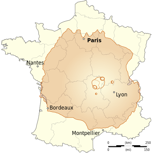
| ဖော်ပြချက် |
English: Comparison between size of France and Olympus Mons (planet Mars), the highest mountain in the solar system.
Français : Comparaison entre les tailles de la France et d'Olympus Mons (planète Mars), la plus haute montagne du système solaire. |
||
| ရက်စွဲ | (UTC) | ||
| ရင်းမြစ် | |||
| စာရေးသူ |
|
||
| အခြား ဗားရှင်းများ | |||
| မှတ်ယူနိုင်ခြင်း (required by the license) | © Sémhur / Wikimedia Commons / | ||
| SVG | W3C-validity not checked.
|
||
| Graphic Lab |

လိုင်စင်သတ်မှတ်ခြင်း
ကျွန်ုပ်၊ ဤလုပ်ဆောင်ချက်၏ မူပိုင်ခွင့်ပိုင်ရှင်အနေဖြင့် ဤနေရာမှ အောက်ပါလိုင်စင်များအောက်တွင် ထုတ်လွှင့်ပါသည်:
| Copyleft: This work of art is free; you can redistribute it and/or modify it according to terms of the Free Art License. You will find a specimen of this license on the Copyleft Attitude site as well as on other sites. |
This file is licensed under the Creative Commons Attribution-Share Alike 4.0 International, 3.0 Unported, 2.5 Generic, 2.0 Generic and 1.0 Generic license.
- သင်သည် လွတ်လပ်စွာ:
- မျှဝေရန် – ဖန်တီးမှုကို ကူးယူရန်၊ ဖြန့်ဖြူးရန်နှင့် ထုတ်လွှင့်ရန်
- ပြန်ရောနှောရန် – ဖန်တီးမှုကို ပြင်ဆင်ညှိနှိုင်းရန်
- အောက်ပါ အခြေအနေများတွင်:
- မှတ်ယူနိုင်ခြင်း – ပြောင်းလဲမှုများ ပြုလုပ်ခဲ့ပါက ဖန်တီးသူ သို့မဟုတ် လိုင်စင်ရှိသူမှ သတ်မှတ်သော အမျိုးအစားကို လိုက်နာရမည် (ဆိုလိုသည်မှာ သင့်အား သို့မဟုတ် သင့်ဖန်တီးမှုတွင် အသုံးပြုခြင်းအား ထောက်ခံချက်ပေးသည်ဟု မဆိုလိုပါ)။
- ထပ်တူမျှဝေ – ဤဖန်တီးမှုအား ပြင်ဆင်ခြင်း၊ ပြောင်းလဲခြင်း သို့မဟုတ် ထပ်ဆင့် ဖန်တီးခြင်း ပြုလုပ်ပါက ရရှိလာသော ဖန်တီးမှုကို ဤဖန်တီးမှုနှင့် သို့မဟုတ် ဆင်တူသော လိုင်စင်ဖြင့်သာ ဖြန့်ချိသင့်သည်။
သင်အလိုရှိရာ လိုင်စင်ကို ရွေးချယ်နိုင်ပါသည်။
မူရင်းတင်ထားသောမှတ်တမ်း
This image is a derivative work of the following images:
- File:Départements_et_régions_de_France.svg licensed with PD-self
- 2008-06-20T07:26:42Z Bayo 588x550 (478078 Bytes) patch region/departement id with ISO 3166-2:FR
- 2008-06-17T09:02:28Z Bayo 588x550 (485696 Bytes) {{Information |Description= |Source= |Date= |Author= |Permission= |other_versions= }}
- 2008-05-10T16:56:23Z Bayo 588x550 (470290 Bytes) region name bigger, patch typo of some names
- 2006-05-22T20:34:29Z Bayo 588x550 (470278 Bytes) patch : typo
- 2006-04-17T15:11:41Z Bayo 588x550 (470275 Bytes) ajout de l'échelle
- 2006-04-17T14:45:23Z Bayo 588x550 (465538 Bytes) *'''description''' : Départements et régions et de France avec leurs préfectures. *'''auteur''' : [[User:bayo|bayo]] [[Category:Maps of departements of France]] [[Category:Maps of régions of France]] == Licensing == {{P
- File:Olympus_Mons_alt.jpg licensed with PD-USGov-NASA
- 2008-12-22T19:18:16Z Diego pmc 2020x1883 (3747949 Bytes) == Summary == {{Information |Description={{en|A composite image of [[:en:Olympus Mons|Olympus Mons]] on [[:en:Mars|Mars]], the tallest known [[:en:Volcano|volcano]] and [[:en:Mountain|mountain]] in the [[Solar System]].}} |So
Uploaded with derivativeFX
ဖိုင်မှတ်တမ်း
ဖိုင်ကို ယင်းနေ့စွဲ အတိုင်း မြင်နိုင်ရန် နေ့စွဲ/အချိန် တစ်ခုခုပေါ်တွင် ကလစ်နှိပ်ပါ။
| နေ့စွဲ/အချိန် | နမူနာပုံငယ် | မှတ်တမ်း ဒိုင်မန်းရှင်းများ | အသုံးပြုသူ | မှတ်ချက် | |
|---|---|---|---|---|---|
| ကာလပေါ် | ၁၅:၁၀၊ ၂၆ မေ ၂၀၁၄ | | ၅၀၀ × ၅၀၀ (၁၁၉ KB) | Sémhur | Valid SVG |
| ၁၅:၅၄၊ ၃၀ မတ် ၂၀၀၉ |  | ၅၀၀ × ၅၀၀ (၁၁၉ KB) | Sémhur | {{Information |Description={{en|Departements and region of France. French geographics objects use ISO 3166-2:FR for ids.}} {{es|Mapa de los departamentos franceses.}} {{fr|Départements et régions de France avec leurs préfectures. Les objects géographi |
ဖိုင်သုံးစွဲမှု
အောက်ပါ စာမျက်နှာ သည် ဤဖိုင်ကို အသုံးပြုထားသည်:
ဂလိုဘယ် ဖိုင်သုံးစွဲမှု
အောက်ပါ အခြားဝီကီများတွင် ဤဖိုင်ကို အသုံးပြုထားသည်-
- en.wikipedia.org တွင် အသုံးပြုမှု
- es.wikipedia.org တွင် အသုံးပြုမှု
- fa.wikipedia.org တွင် အသုံးပြုမှု
- fi.wikipedia.org တွင် အသုံးပြုမှု
- fr.wikipedia.org တွင် အသုံးပြုမှု
- he.wikipedia.org တွင် အသုံးပြုမှု
- hr.wikipedia.org တွင် အသုံးပြုမှု
- it.wikipedia.org တွင် အသုံးပြုမှု
- ko.wikipedia.org တွင် အသုံးပြုမှု
- mr.wikipedia.org တွင် အသုံးပြုမှု
- nap.wikipedia.org တွင် အသုံးပြုမှု
- ro.wikipedia.org တွင် အသုံးပြုမှု
- sl.wikipedia.org တွင် အသုံးပြုမှု