ဖိုင်:Taiwan relief location map.jpg

အခြားဘာသာစကားများဖြင့် စာမျက်နှာအကြောင်းအရာများကို ပံ့ပိုးမထားပါ။
This is a file from the Wikimedia Commons
ဝီကီပီးဒီးယား မှ

မူရင်းဖိုင်(၁၀၁၆ × ၁၂၂၂ pixels, ဖိုင်အရွယ်အစား - ၁၀၁ KB, MIME အမျိုးအစား image/jpeg)

Warning sign This file requires updating because: The earlier forms of this map did not extend a dotted-line around Dongyin, Lienchiang (Tungyin). The northern edge of this map ought to be moved up a little bit (in latitude) so that a dotted line encompassing Dongyin (Tungyin) can be clearly drawn and so that we can see a few of the islands north of Lienchiang County in Haidao Township, PRC. Example of a better map from The Economist: [1]. In doing so, you could add a timestamp to the file.
Please notify the uploader with {{subst:update-note|1=File:Taiwan relief location map.jpg|2=The earlier forms of this map did not extend a dotted-line around Dongyin, Lienchiang (Tungyin). The northern edge of this map ought to be moved up a little bit (in latitude) so that a dotted line encompassing Dongyin (Tungyin) can be clearly drawn and so that we can see a few of the islands north of Lienchiang County in Haidao Township, PRC. Example of a better map from The Economist: [2].}} ~~~~

အကျဉ်းချုပ်

ဖော်ပြချက်
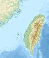
English: Relief location map of Taiwan.
  • Projection: Equirectangular projection, strechted by 110.0%.
  • Geographic limits of the map:
  • N: 26.4° N
  • S: 21.7° N
  • W: 118.0° E
  • E: 122.3° E
  • GMT projection: -JX17.204266666666665cd/20.68512992248063cd
  • GMT region: -R118.0/21.7/122.3/26.4r
  • GMT region for grdcut: -R118.0/21.7/122.3/26.4r
  • Relief: SRTM30plus.
  • Made with Natural Earth. Free vector and raster map data @ naturalearthdata.com.
ရက်စွဲ
ရင်းမြစ် ကိုယ်ပိုင်ဖန်တီးမှု
စာရေးသူ Uwe Dedering

လိုင်စင်သတ်မှတ်ခြင်း

ကျွန်ုပ်၊ ဤလုပ်ဆောင်ချက်၏ မူပိုင်ခွင့်ပိုင်ရှင်အနေဖြင့် ဤနေရာမှ အောက်ပါလိုင်စင်များအောက်တွင် ထုတ်လွှင့်ပါသည်:
w:my:Creative Commons
မှတ်ယူနိုင်ခြင်း ထပ်တူမျှဝေ
ဤဖိုင်သည် Creative Commons Attribution-Share Alike 3.0 Unported, 2.5 Generic, 2.0 Generic နှင့် 1.0 Generic လိုင်စင်အောက်တွင် လိုင်စင်သတ်မှတ်ထားပါသည်။
သင်သည် လွတ်လပ်စွာ:
  • မျှဝေရန် – ဖန်တီးမှုကို ကူးယူရန်၊ ဖြန့်ဖြူးရန်နှင့် ထုတ်လွှင့်ရန်
  • ပြန်ရောနှောရန် – ဖန်တီးမှုကို ပြင်ဆင်ညှိနှိုင်းရန်
အောက်ပါ အခြေအနေများတွင်:
  • မှတ်ယူနိုင်ခြင်း – ပြောင်းလဲမှုများ ပြုလုပ်ခဲ့ပါက ဖန်တီးသူ သို့မဟုတ် လိုင်စင်ရှိသူမှ သတ်မှတ်သော အမျိုးအစားကို လိုက်နာရမည် (ဆိုလိုသည်မှာ သင့်အား သို့မဟုတ် သင့်ဖန်တီးမှုတွင် အသုံးပြုခြင်းအား ထောက်ခံချက်ပေးသည်ဟု မဆိုလိုပါ)။
  • ထပ်တူမျှဝေ – ဤဖန်တီးမှုအား ပြင်ဆင်ခြင်း၊ ပြောင်းလဲခြင်း သို့မဟုတ် ထပ်ဆင့် ဖန်တီးခြင်း ပြုလုပ်ပါက ရရှိလာသော ဖန်တီးမှုကို ဤဖန်တီးမှုနှင့် သို့မဟုတ် ဆင်တူသော လိုင်စင်ဖြင့်သာ ဖြန့်ချိသင့်သည်။
GNU head ဤစာတမ်းကို GNU Free Documentation License, ဗားရှင်း ၁.၂ သို့မဟုတ် Free Software Foundation မှ ဖြန့်ချီထားသော မည်သည့်ယခင်ဗားရှင်းတစ်ခုခုအောက်တွင် Invariant Sections, Front-Cover Texts နှင့် Back-Cover Texts များမပါဝင်ဘဲ ကူးယူခြင်း၊ ဖြန့်ချီခြင်း နှင့်/သို့မဟုတ် ပြင်ဆင်ပြောင်းလဲနိုင်ရန် ခွင့်ပြုသည်။ လိုင်စင်မူပွားကို GNU Free Documentation License ခေါင်းစဉ်အောက်တွင် ထည့်သွင်းထားသည်။
သင်အလိုရှိရာ လိုင်စင်ကို ရွေးချယ်နိုင်ပါသည်။

ပုံစာများ

ဤဖိုင်၏ဆိုလိုရင်းကို စာတစ်ကြောင်းရှင်းလင်းချက်ဖြင့် ထည့်သွင်းရန်

Items portrayed in this file

depicts အင်္ဂလိပ်

MIME type အင်္ဂလိပ်

image/jpeg

ဖိုင်မှတ်တမ်း

ဖိုင်ကို ယင်းနေ့စွဲ အတိုင်း မြင်နိုင်ရန် နေ့စွဲ/အချိန် တစ်ခုခုပေါ်တွင် ကလစ်နှိပ်ပါ။

နေ့စွဲ/အချိန်နမူနာပုံငယ်မှတ်တမ်း ဒိုင်မန်းရှင်းများအသုံးပြုသူမှတ်ချက်
ကာလပေါ် ၁၄:၀၁၊ ၁၉ စက်တင်ဘာ ၂၀၁၉ ၁၄:၀၁၊ ၁၉ စက်တင်ဘာ ၂၀၁၉ ရက်က မူအတွက် နမူနာပုံငယ်၁၀၁၆ × ၁၂၂၂ (၁၀၁ KB)Geographyinitiativetemporary fix: extending the boundary out around Dongyin Township (as in China Fujian2 location map.svg and as in File:Nationalist China - administrative divisons. LOC 2007633622.jpg)
၁၇:၀၉၊ ၃ ဩဂုတ် ၂၀၁၉ ၁၇:၀၉၊ ၃ ဩဂုတ် ၂၀၁၉ ရက်က မူအတွက် နမူနာပုံငယ်၁၀၁၆ × ၁၂၂၂ (၅၃၇ KB)NordNordWestborder corrections
၀၁:၅၁၊ ၃ ဩဂုတ် ၂၀၁၉ ၀၁:၅၁၊ ၃ ဩဂုတ် ၂၀၁၉ ရက်က မူအတွက် နမူနာပုံငယ်၁၀၁၆ × ၁၂၂၂ (၉၆ KB)GeographyinitiativeProposed removal of three dashes (markers of the approximate PRC/ROC maritime boundary) which seemed to put Dadan Island, Erdan Island and Binlang Islet (檳榔嶼) outside the territory of Kinmen County, Taiwan/ROC. This is not the optimal form of the map, but is merely a quick removal of incorrect information. In the optimal situation, the line needs to be redrawn in the correct location, but I don't have the technical skill to produce such a map. (Basis: [http://ws.mac.gov.tw/001/Upload/OldFile/...
၀၀:၃၀၊ ၃ ဩဂုတ် ၂၀၁၉ ၀၀:၃၀၊ ၃ ဩဂုတ် ၂၀၁၉ ရက်က မူအတွက် နမူနာပုံငယ်၁၀၁၆ × ၁၂၂၂ (၉၆ KB)GeographyinitiativeProposed removal of two dashes (markers of the approximate PRC/ROC maritime boundary) which seemed to put {{w|Dadan Island}} and {{w|Erdan Island}} outside the territory of {{w|Kinmen County}}, Taiwan/ROC.
၁၇:၂၂၊ ၂၈ ဒီဇင်ဘာ ၂၀၁၀ ၁၇:၂၂၊ ၂၈ ဒီဇင်ဘာ ၂၀၁၀ ရက်က မူအတွက် နမူနာပုံငယ်၁၀၁၆ × ၁၂၂၂ (၄၅၂ KB)Uwe Dedering{{Information |Description={{en|1=Relief location map of Taiwan. * Projection: Equirectangular projection, strechted by 110.0%. * Geographic limits of the map: :* N: 26.4° N :* S: 21.7° N :* W: 118.0° E :* E: 122.3° E * GMT projection: -JX17.204266666

အောက်ပါ 3 စာမျက်နှာများ သည် ဤဖိုင်ကို အသုံးပြုထားသည်:

ဂလိုဘယ် ဖိုင်သုံးစွဲမှု

အောက်ပါ အခြားဝီကီများတွင် ဤဖိုင်ကို အသုံးပြုထားသည်-

ဤဖိုင်ကို အခြားနေရာများတွင် အသုံးပြုထားမှုများအား ကြည့်ရှုရန်။

မီတာဒေတာ