
ဖိုင်:Topografic map of Tibetan Plateau.png

ဤနမူနာ၏ အရွယ်အစား - ၈၀၀ × ၄၂၉ ပစ်ဇယ်။ အခြား ပုံရိပ်ပြတ်သားမှု: ၃၂၀ × ၁၇၂ ပစ်ဇယ် | ၆၄၀ × ၃၄၃ ပစ်ဇယ် | ၁၃၆၅ × ၇၃၂ ပစ်ဇယ်။
မူရင်းဖိုင် (၁၃၆၅ × ၇၃၂ pixels, ဖိုင်အရွယ်အစား - ၆၆၃ KB, MIME အမျိုးအစား image/png)
| ဤဖိုင်သည် Wikimedia Commons မှဖြစ်ပြီး အခြားပရောဂျက်များတွင် သုံးကောင်းသုံးလိမ့်မည်။ ယင်း၏ ဖိုင်အကြောင်းစာမျက်နှာ တွင် ဖော်ပြထားချက်ကို အောက်တွင် ပြထားသည်။ Commons သည် မူပိုင်ခွင့်လွတ်လပ်သော မီဒီယာဖိုင်များ သိုလှောင်ထားရာ နေရာ ဖြစ်သည်။ သင်လည်း ပါဝင်ကူညီနိုင်ပါသည်။ |
| ဖော်ပြချက် |
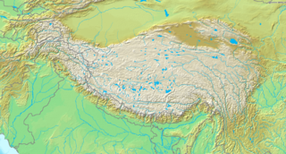
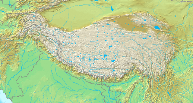
English: Topografic map of the Tibetan Plateau in Asia.
Français : Carte topographique du plateau tibetain.
|
||||
| ရက်စွဲ | ရက်စွဲ မသိရ | ||||
| ရင်းမြစ် | http://www.demis.nl/home/pages/Gallery/examples.htm | ||||
| စာရေးသူ | မသိရှိရ | ||||
| ခွင့်ပြုချက် (ဤဖိုင်ကို ပြန်လည်အသုံးပြုခြင်း) |
|
ဖိုင်မှတ်တမ်း
ဖိုင်ကို ယင်းနေ့စွဲ အတိုင်း မြင်နိုင်ရန် နေ့စွဲ/အချိန် တစ်ခုခုပေါ်တွင် ကလစ်နှိပ်ပါ။
| နေ့စွဲ/အချိန် | နမူနာပုံငယ် | မှတ်တမ်း ဒိုင်မန်းရှင်းများ | အသုံးပြုသူ | မှတ်ချက် | |
|---|---|---|---|---|---|
| ကာလပေါ် | ၁၉:၅၁၊ ၂၆ မတ် ၂၀၀၉ | | ၁၃၆၅ × ၇၃၂ (၆၆၃ KB) | Botev | borders bold, lakes filled in blue |
| ၁၉:၀၂၊ ၂ စက်တင်ဘာ ၂၀၀၅ |  | ၁၃၆၅ × ၇၃၂ (၇၁၀ KB) | Mats Halldin~commonswiki | Map of Himalaya Bounding box West 66°, South 23°, East 108°, North 42°. {{demis-pd}} category:maps of Himalaya |
ဖိုင်သုံးစွဲမှု
အောက်ပါ စာမျက်နှာ သည် ဤဖိုင်ကို အသုံးပြုထားသည်:
ဂလိုဘယ် ဖိုင်သုံးစွဲမှု
အောက်ပါ အခြားဝီကီများတွင် ဤဖိုင်ကို အသုံးပြုထားသည်-
- ar.wikipedia.org တွင် အသုံးပြုမှု
- ba.wikipedia.org တွင် အသုံးပြုမှု
- be-tarask.wikipedia.org တွင် အသုံးပြုမှု
- bn.wikipedia.org တွင် အသုံးပြုမှု
- ceb.wikipedia.org တွင် အသုံးပြုမှု
- ce.wikipedia.org တွင် အသုံးပြုမှု
- da.wikipedia.org တွင် အသုံးပြုမှု
- de.wikipedia.org တွင် အသုံးပြုမှု
- en.wikipedia.org တွင် အသုံးပြုမှု
- Gyachung Kang
- 1950 Assam–Tibet earthquake
- Geladaindong Peak
- Karuo culture
- Haba Snow Mountain
- Anisodus tanguticus
- Outline of Tibet
- Alpine steppe
- Kang Yatze
- Module:Location map/data/Tibetan Plateau/doc
- User:BIO341prj
- 1927 Gulang earthquake
- 1932 Changma earthquake
- Pauhunri
- Guozha Lake
- User:HueSatLum/II
- Singhi Kangri
- Module:Location map/data/Tibetan Plateau
- Gasherbrum VI
- Phrynocephalus vlangalii
- eu.wikipedia.org တွင် အသုံးပြုမှု
- fa.wikipedia.org တွင် အသုံးပြုမှု
- fo.wikipedia.org တွင် အသုံးပြုမှု
- fr.wikipedia.org တွင် အသုံးပြုမှု
- fr.wikibooks.org တွင် အသုံးပြုမှု
- gcr.wikipedia.org တွင် အသုံးပြုမှု
- hi.wikipedia.org တွင် အသုံးပြုမှု
ဤဖိုင်ကို အခြားနေရာများတွင် အသုံးပြုထားမှုများအား ကြည့်ရှုရန်။