
ဖိုင်:Political map of Canada.svg

Size of this PNG preview of this SVG file: ၇၃၆ × ၅၉၉ ပစ်ဇယ်. အခြား ပုံရိပ်ပြတ်သားမှု: ၂၉၅ × ၂၄၀ ပစ်ဇယ် | ၅၉၀ × ၄၈၀ ပစ်ဇယ် | ၉၄၃ × ၇၆၈ ပစ်ဇယ် | ၁၂၅၈ × ၁၀၂၄ ပစ်ဇယ် | ၂၅၁၆ × ၂၀၄၈ ပစ်ဇယ် | ၁၁၃၀ × ၉၂၀ ပစ်ဇယ်။
မူရင်းဖိုင် (SVG ဖိုင်, ၁၁၃၀ × ၉၂၀ pixels ကို အကြံပြုသည်, ဖိုင်အရွယ်အစား - ၂၇၂ KB)
| ဤဖိုင်သည် Wikimedia Commons မှဖြစ်ပြီး အခြားပရောဂျက်များတွင် သုံးကောင်းသုံးလိမ့်မည်။ ယင်း၏ ဖိုင်အကြောင်းစာမျက်နှာ တွင် ဖော်ပြထားချက်ကို အောက်တွင် ပြထားသည်။ Commons သည် မူပိုင်ခွင့်လွတ်လပ်သော မီဒီယာဖိုင်များ သိုလှောင်ထားရာ နေရာ ဖြစ်သည်။ သင်လည်း ပါဝင်ကူညီနိုင်ပါသည်။ |
အကျဉ်းချုပ်
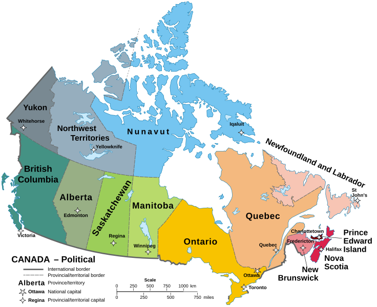
| ဖော်ပြချက် |
English: A map of Canada in its Provinces and territories Català: Mapa de les províncies i territoris del Canadà. |
||
| ရက်စွဲ | |||
| ရင်းမြစ် | Localisation Manitoba.svg | ||
| စာရေးသူ | Hogweard | ||
| ခွင့်ပြုချက် (ဤဖိုင်ကို ပြန်လည်အသုံးပြုခြင်း) |
|
||
| အခြား ဗားရှင်းများ |
Carte Politique du Canada.svg File:Political map of Canada.svg has 1 translations.
|

ဖိုင်မှတ်တမ်း
ဖိုင်ကို ယင်းနေ့စွဲ အတိုင်း မြင်နိုင်ရန် နေ့စွဲ/အချိန် တစ်ခုခုပေါ်တွင် ကလစ်နှိပ်ပါ။
| နေ့စွဲ/အချိန် | နမူနာပုံငယ် | မှတ်တမ်း ဒိုင်မန်းရှင်းများ | အသုံးပြုသူ | မှတ်ချက် | |
|---|---|---|---|---|---|
| ကာလပေါ် | ၁၁:၅၈၊ ၂၂ စက်တင်ဘာ ၂၀၂၃ | | ၁၁၃၀ × ၉၂၀ (၂၇၂ KB) | Lalpino | File uploaded using svgtranslate tool (https://svgtranslate.toolforge.org/). Added translation for ca. |
| ၁၄:၅၈၊ ၁၄ အောက်တိုဘာ ၂၀၂၂ |  | ၁၁၃၀ × ၉၂၀ (၂၅၆ KB) | Enkhsaihan2005 | File uploaded using svgtranslate tool (https://svgtranslate.toolforge.org/). Added translation for mn. | |
| ၀၀:၄၃၊ ၂၁ ဇွန် ၂၀၂၂ |  | ၁၁၃၀ × ၉၂၀ (၂၁၁ KB) | -tynjee | File uploaded using svgtranslate tool (https://svgtranslate.toolforge.org/). Added translation for vi. | |
| ၀၂:၂၁၊ ၂၃ ဩဂုတ် ၂၀၂၁ |  | ၁၁၃၀ × ၉၂၀ (၁၉၉ KB) | Praça de Maio | File uploaded using svgtranslate tool (https://svgtranslate.toolforge.org/). Added translation for tr. | |
| ၀၁:၅၉၊ ၂၉ ဇန်နဝါရီ ၂၀၂၁ |  | ၁၁၃၀ × ၉၂၀ (၁၆၁ KB) | Allice Hunter | Reverted to version as of 11:37, 19 October 2020 (UTC) | |
| ၀၁:၅၉၊ ၂၉ ဇန်နဝါရီ ၂၀၂၁ |  | ၅၁၂ × ၄၂၄ (၉၅ KB) | Allice Hunter | Largest cities | |
| ၁၁:၃၇၊ ၁၉ အောက်တိုဘာ ၂၀၂၀ |  | ၁၁၃၀ × ၉၂၀ (၁၆၁ KB) | Hogweard | Fixed N&L label | |
| ၀၈:၄၈၊ ၁၈ အောက်တိုဘာ ၂၀၂၀ |  | ၁၁၃၀ × ၉၂၀ (၁၆၁ KB) | Hogweard | {{Information |description=A map of Canada in its Provinces and territories |date=2020-10-18 |source={{f|Localisation_Manitoba.svg}} |author={{u|Hogweard}} |permission={{PD-self}} |other versions={{f|Carte Politique du Canada.svg}} }} Category:SVG maps of Canada Category:English language maps of Canada Category:Political maps of Canada |
ဖိုင်သုံးစွဲမှု
အောက်ပါ စာမျက်နှာ သည် ဤဖိုင်ကို အသုံးပြုထားသည်:
ဂလိုဘယ် ဖိုင်သုံးစွဲမှု
အောက်ပါ အခြားဝီကီများတွင် ဤဖိုင်ကို အသုံးပြုထားသည်-
- as.wikipedia.org တွင် အသုံးပြုမှု
- azb.wikipedia.org တွင် အသုံးပြုမှု
- bh.wikipedia.org တွင် အသုံးပြုမှု
- br.wikipedia.org တွင် အသုံးပြုမှု
- ca.wikipedia.org တွင် အသုံးပြုမှု
- el.wikipedia.org တွင် အသုံးပြုမှု
- en.wikipedia.org တွင် အသုံးပြုမှု
- io.wikipedia.org တွင် အသုံးပြုမှု
- ku.wikipedia.org တွင် အသုံးပြုမှု
- mdf.wikipedia.org တွင် အသုံးပြုမှု
- mn.wikipedia.org တွင် အသုံးပြုမှု
- pa.wikipedia.org တွင် အသုံးပြုမှု
- sq.wikipedia.org တွင် အသုံးပြုမှု
- sr.wikipedia.org တွင် အသုံးပြုမှု
- tl.wikipedia.org တွင် အသုံးပြုမှု
- to.wikipedia.org တွင် အသုံးပြုမှု
- tr.wikipedia.org တွင် အသုံးပြုမှု
- uk.wikipedia.org တွင် အသုံးပြုမှု
- vi.wikipedia.org တွင် အသုံးပြုမှု