
ဖိုင်:Miyagi-ken géolocalisation relief.svg

Size of this PNG preview of this SVG file: ၄၉၈ × ၅၉၉ ပစ်ဇယ်. အခြား ပုံရိပ်ပြတ်သားမှု: ၁၉၉ × ၂၄၀ ပစ်ဇယ် | ၃၉၉ × ၄၈၀ ပစ်ဇယ် | ၆၃၈ × ၇၆၈ ပစ်ဇယ် | ၈၅၁ × ၁၀၂၄ ပစ်ဇယ် | ၁၇၀၂ × ၂၀၄၈ ပစ်ဇယ် | ၁၇၀၃ × ၂၀၄၉ ပစ်ဇယ်။
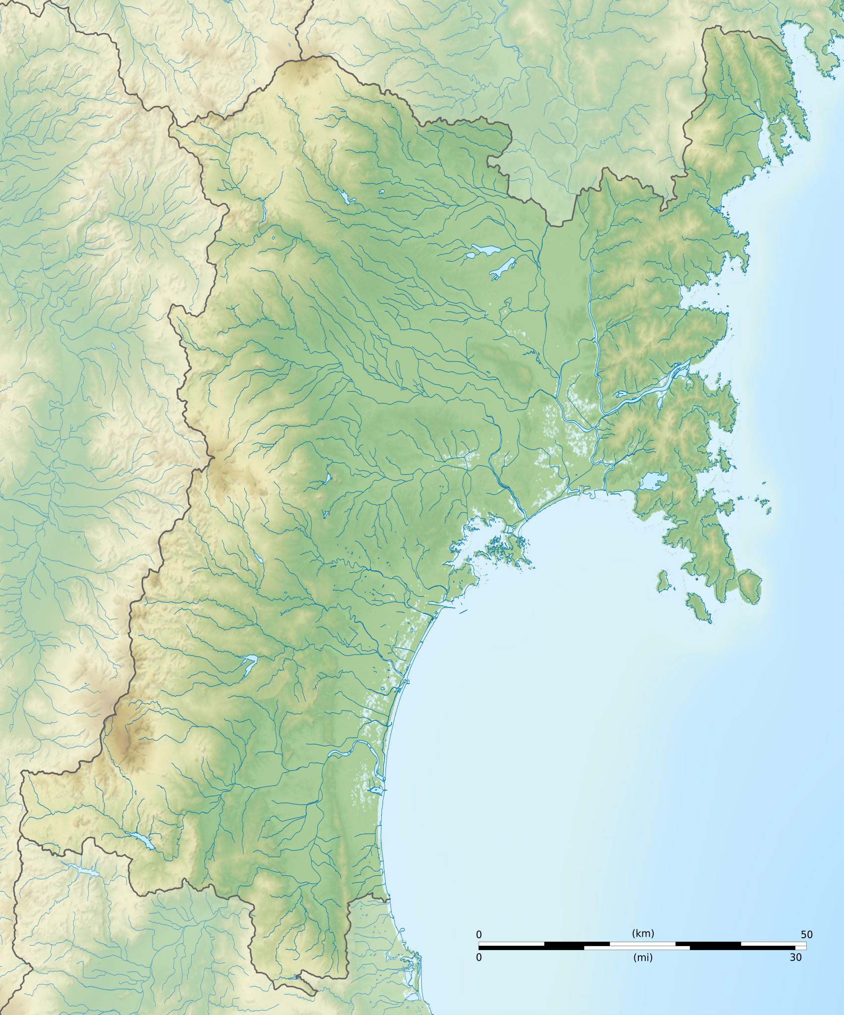
မူရင်းဖိုင် (SVG ဖိုင်, ၁၇၀၃ × ၂၀၄၉ pixels ကို အကြံပြုသည်, ဖိုင်အရွယ်အစား - ၃.၂၁ MB)
| ဤဖိုင်သည် Wikimedia Commons မှဖြစ်ပြီး အခြားပရောဂျက်များတွင် သုံးကောင်းသုံးလိမ့်မည်။ ယင်း၏ ဖိုင်အကြောင်းစာမျက်နှာ တွင် ဖော်ပြထားချက်ကို အောက်တွင် ပြထားသည်။ Commons သည် မူပိုင်ခွင့်လွတ်လပ်သော မီဒီယာဖိုင်များ သိုလှောင်ထားရာ နေရာ ဖြစ်သည်။ သင်လည်း ပါဝင်ကူညီနိုင်ပါသည်။ |
အကျဉ်းချုပ်
| Camera location | | View this and other nearby images on: OpenStreetMap |
|---|
| ဖော်ပြချက် |
Français : Carte topographique vierge de la Préfecture de Miyagi, au Japon, destinée à la géolocalisation.
Deutsch: Topographische Karte der Präfektur Miyagi.
English: Topographic blank map of the Miyagi Prefecture, for geolocalisation purpose.
Español: Mapa topográfico de la Prefectura de Miyagi.
Italiano: Mappa topografica della Prefettura di Miyagi.
日本語: 宮城県の地図.
Português: Carta topográfica de la província de Miyagi.
|
||
| ရက်စွဲ | (UTC) | ||
| ရင်းမြစ် |
Création personnelle ;
|
||
| စာရေးသူ | © Bourrichon (talk) - fr:Bourrichon | ||
| ခွင့်ပြုချက် (ဤဖိုင်ကို ပြန်လည်အသုံးပြုခြင်း) |
|
||
| အခြား ဗားရှင်းများ | File:Miyagi-ken géolocalisation.svg |
This W3C-unspecified vector image was created with Inkscape .
လိုင်စင်သတ်မှတ်ခြင်း
ကျွန်ုပ်၊ ဤလုပ်ဆောင်ချက်၏ မူပိုင်ခွင့်ပိုင်ရှင်အနေဖြင့် ဤနေရာမှ အောက်ပါလိုင်စင်အောက်တွင် ထုတ်လွှင့်ပါသည်:
ဤဖိုင်သည် Creative Commons Attribution-Share Alike 2.0 ပြင်သစ် လိုင်စင်အောက်တွင် လိုင်စင်သတ်မှတ်ထားပါသည်။
မှတ်ယူနိုင်ခြင်း: Bourrichon (atelier graphique)
- သင်သည် လွတ်လပ်စွာ:
- မျှဝေရန် – ဖန်တီးမှုကို ကူးယူရန်၊ ဖြန့်ဖြူးရန်နှင့် ထုတ်လွှင့်ရန်
- ပြန်ရောနှောရန် – ဖန်တီးမှုကို ပြင်ဆင်ညှိနှိုင်းရန်
- အောက်ပါ အခြေအနေများတွင်:
- မှတ်ယူနိုင်ခြင်း – ပြောင်းလဲမှုများ ပြုလုပ်ခဲ့ပါက ဖန်တီးသူ သို့မဟုတ် လိုင်စင်ရှိသူမှ သတ်မှတ်သော အမျိုးအစားကို လိုက်နာရမည် (ဆိုလိုသည်မှာ သင့်အား သို့မဟုတ် သင့်ဖန်တီးမှုတွင် အသုံးပြုခြင်းအား ထောက်ခံချက်ပေးသည်ဟု မဆိုလိုပါ)။
- ထပ်တူမျှဝေ – ဤဖန်တီးမှုအား ပြင်ဆင်ခြင်း၊ ပြောင်းလဲခြင်း သို့မဟုတ် ထပ်ဆင့် ဖန်တီးခြင်း ပြုလုပ်ပါက ရရှိလာသော ဖန်တီးမှုကို ဤဖန်တီးမှုနှင့် သို့မဟုတ် ဆင်တူသော လိုင်စင်ဖြင့်သာ ဖြန့်ချိသင့်သည်။

ဖိုင်မှတ်တမ်း
ဖိုင်ကို ယင်းနေ့စွဲ အတိုင်း မြင်နိုင်ရန် နေ့စွဲ/အချိန် တစ်ခုခုပေါ်တွင် ကလစ်နှိပ်ပါ။
| နေ့စွဲ/အချိန် | နမူနာပုံငယ် | မှတ်တမ်း ဒိုင်မန်းရှင်းများ | အသုံးပြုသူ | မှတ်ချက် | |
|---|---|---|---|---|---|
| ကာလပေါ် | ၁၇:၁၀၊ ၁၀ ဇူလိုင် ၂၀၁၃ | | ၁၇၀၃ × ၂၀၄၉ (၃.၂၁ MB) | Bourrichon | erreur |
| ၁၇:၀၅၊ ၁၀ ဇူလိုင် ၂၀၁၃ |  | ၁၇၀၃ × ၂၀၄၉ (၂.၉ MB) | Bourrichon | == {{int:filedesc}} == {{Location|38|30|00|N|141|00|00|E|scale:10000}} {{Information |Description= {{fr|Carte topographique vierge de la fr:Préfecture de Miyagi, au Japon, destinée à la géolocalisation.}} {{de|Topographische Ka... |
ဖိုင်သုံးစွဲမှု
အောက်ပါ 2 စာမျက်နှာများ သည် ဤဖိုင်ကို အသုံးပြုထားသည်:
ဂလိုဘယ် ဖိုင်သုံးစွဲမှု
အောက်ပါ အခြားဝီကီများတွင် ဤဖိုင်ကို အသုံးပြုထားသည်-
- ar.wikipedia.org တွင် အသုံးပြုမှု
- ceb.wikipedia.org တွင် အသုံးပြုမှု
- ce.wikipedia.org တွင် အသုံးပြုမှု
- de.wikipedia.org တွင် အသုံးပြုမှု
- en.wikipedia.org တွင် အသုံးပြုမှု
- Mount Funagata
- Sakunami Onsen
- Oshika Peninsula
- Kamei Arena Sendai
- Zuigan-ji
- Aoba Castle
- JCB Classic
- Shiroishi Castle
- Kakuda Space Center
- Aratozawa Dam
- Hanayama Dam
- Kamafusa Dam
- Kejyonuma Dam
- Kurikoma Dam
- Minamikawa Dam
- Miyatoko Dam
- Naganuma Dam
- Nanakita Dam
- Naruko Dam
- Shichikashuku Dam
- Urushizawa Dam
- Taga Castle
- Entsū-in (Matsushima)
- Kōzō-ji (Kakuda)
- Saitō Garden (Ishinomaki)
- Satohama shell mound
- Mutsu Kokubun-ji
- Yūbikan
- Iwadeyama Castle
- Zaō Quasi-National Park
- Kurikoma Quasi-National Park
- Matsushima Prefectural Natural Park
- Zaō Kōgen Prefectural Natural Park
- Funagata Renpō Prefectural Natural Park
- Kenjōsan Mangokuura Prefectural Natural Park
- Akiu Great Falls
ဤဖိုင်ကို အခြားနေရာများတွင် အသုံးပြုထားမှုများအား ကြည့်ရှုရန်။