
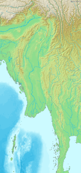
ဖိုင်:Map of Myanmar Demis.png

ဤနမူနာ၏ အရွယ်အစား - ၂၈၂ × ၅၉၈ ပစ်ဇယ်။ အခြား ပုံရိပ်ပြတ်သားမှု: ၁၁၃ × ၂၄၀ ပစ်ဇယ် | ၂၂၆ × ၄၈၀ ပစ်ဇယ် | ၆၈၇ × ၁၄၅၇ ပစ်ဇယ်။
မူရင်းဖိုင် (၆၈၇ × ၁၄၅၇ pixels, ဖိုင်အရွယ်အစား - ၄၉၈ KB, MIME အမျိုးအစား image/png)
| ဤဖိုင်သည် Wikimedia Commons မှဖြစ်ပြီး အခြားပရောဂျက်များတွင် သုံးကောင်းသုံးလိမ့်မည်။ ယင်း၏ ဖိုင်အကြောင်းစာမျက်နှာ တွင် ဖော်ပြထားချက်ကို အောက်တွင် ပြထားသည်။ Commons သည် မူပိုင်ခွင့်လွတ်လပ်သော မီဒီယာဖိုင်များ သိုလှောင်ထားရာ နေရာ ဖြစ်သည်။ သင်လည်း ပါဝင်ကူညီနိုင်ပါသည်။ |
Map of Myanmar
Bounding box West 91°, South 9°, East 101.5°, North 30°. Center at 19°30′00″N 96°15′00″E / 19.50000°N 96.25000°E.
This image is in the public domain because it came from the site https://www.demis.nl/products/web-map-server/examples/ and was released by the copyright holder. Permission is granted to copy, distribute and/or modify this map since it is based on free of copyright images from: www.demis.nl. See also approval email on de.wp and its clarification.
|
| This work has been released into the public domain by its copyright holder, www.demis.nl. This applies worldwide. In some countries this may not be legally possible; if so: www.demis.nl grants anyone the right to use this work for any purpose, without any conditions, unless such conditions are required by law.
|
ဖိုင်မှတ်တမ်း
ဖိုင်ကို ယင်းနေ့စွဲ အတိုင်း မြင်နိုင်ရန် နေ့စွဲ/အချိန် တစ်ခုခုပေါ်တွင် ကလစ်နှိပ်ပါ။
| နေ့စွဲ/အချိန် | နမူနာပုံငယ် | မှတ်တမ်း ဒိုင်မန်းရှင်းများ | အသုံးပြုသူ | မှတ်ချက် | |
|---|---|---|---|---|---|
| ကာလပေါ် | ၁၈:၃၆၊ ၂၀ ဒီဇင်ဘာ ၂၀၀၆ | | ၆၈၇ × ၁၄၅၇ (၄၉၈ KB) | Mats Halldin~commonswiki | Map of Myanmar Bounding box West 91°, South 9°, East 101.5°, North 30°. Center at {{coor d|19.50000|N|96.25000|E|scale:12600000}}. {{demis-pd}} category:maps of Myanmar |
ဖိုင်သုံးစွဲမှု
အောက်ပါ စာမျက်နှာ သည် ဤဖိုင်ကို အသုံးပြုထားသည်:
ဂလိုဘယ် ဖိုင်သုံးစွဲမှု
အောက်ပါ အခြားဝီကီများတွင် ဤဖိုင်ကို အသုံးပြုထားသည်-
- ar.wikipedia.org တွင် အသုံးပြုမှု
- en.wikipedia.org တွင် အသုံးပြုမှု
- es.wikipedia.org တွင် အသုံးပြုမှု
- fr.wikipedia.org တွင် အသုံးပြုမှု
- la.wikipedia.org တွင် အသုံးပြုမှု
- sq.wikipedia.org တွင် အသုံးပြုမှု
- uk.wikipedia.org တွင် အသုံးပြုမှု