
ဖိုင်:Night lights of Iran.jpg
မူရင်းဖိုင် (၅၆၃၀ × ၅၅၈၀ pixels, ဖိုင်အရွယ်အစား - ၂.၀၆ MB, MIME အမျိုးအစား image/jpeg)
| ဤဖိုင်သည် Wikimedia Commons မှဖြစ်ပြီး အခြားပရောဂျက်များတွင် သုံးကောင်းသုံးလိမ့်မည်။ ယင်း၏ ဖိုင်အကြောင်းစာမျက်နှာ တွင် ဖော်ပြထားချက်ကို အောက်တွင် ပြထားသည်။ Commons သည် မူပိုင်ခွင့်လွတ်လပ်သော မီဒီယာဖိုင်များ သိုလှောင်ထားရာ နေရာ ဖြစ်သည်။ သင်လည်း ပါဝင်ကူညီနိုင်ပါသည်။ |
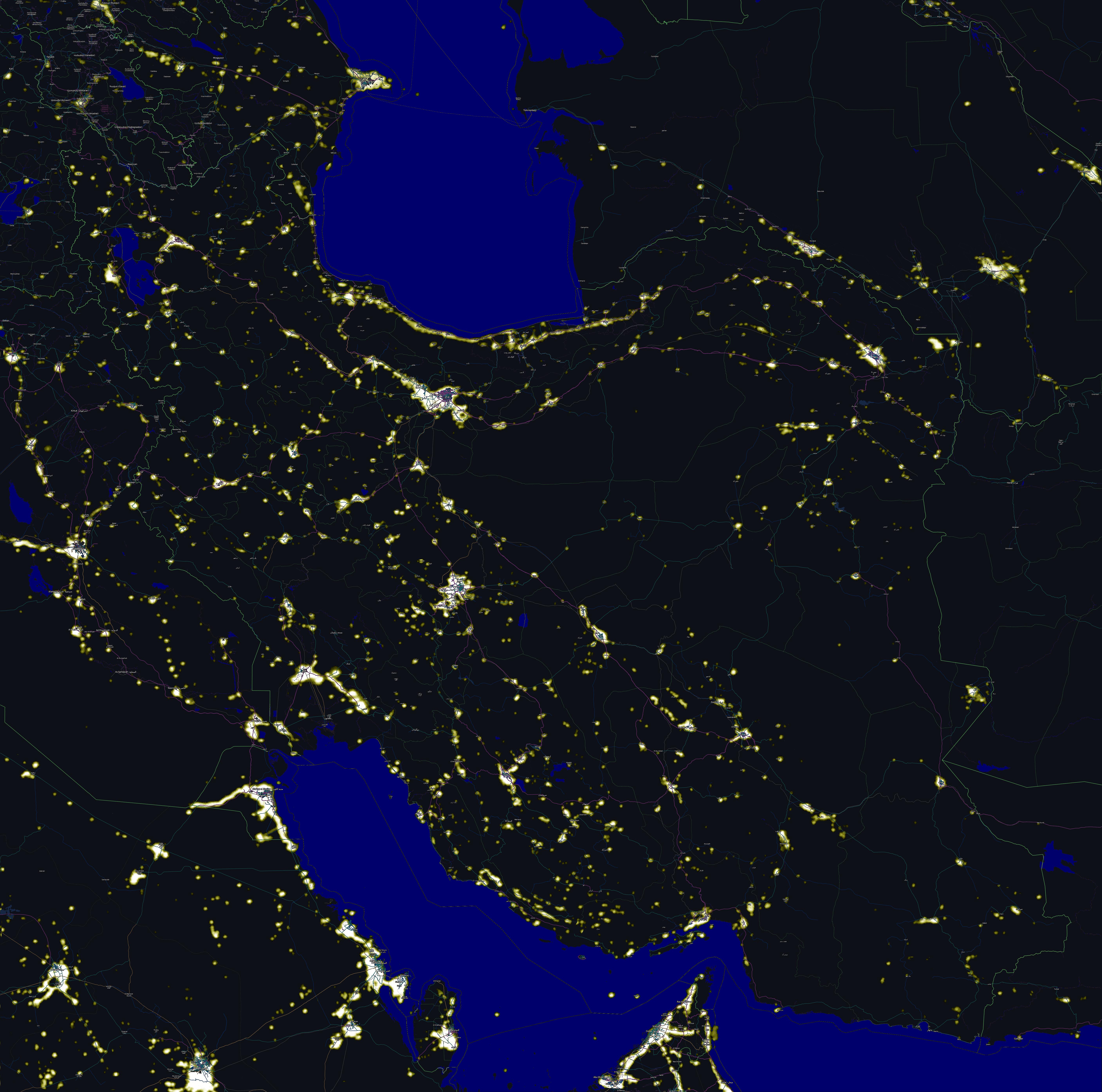
| ဖော်ပြချက် | Comparing map, Night lights of Iran and The map including cities names. |
| ရက်စွဲ | |
| ရင်းမြစ် | I have combined two pictures, one has taken from OpenStreetMap and another one is a Nasa picture can be found here |
| စာရေးသူ | self |
|
- သင်သည် လွတ်လပ်စွာ:
- မျှဝေရန် – ဖန်တီးမှုကို ကူးယူရန်၊ ဖြန့်ဖြူးရန်နှင့် ထုတ်လွှင့်ရန်
- ပြန်ရောနှောရန် – ဖန်တီးမှုကို ပြင်ဆင်ညှိနှိုင်းရန်
- အောက်ပါ အခြေအနေများတွင်:
- မှတ်ယူနိုင်ခြင်း – ပြောင်းလဲမှုများ ပြုလုပ်ခဲ့ပါက ဖန်တီးသူ သို့မဟုတ် လိုင်စင်ရှိသူမှ သတ်မှတ်သော အမျိုးအစားကို လိုက်နာရမည် (ဆိုလိုသည်မှာ သင့်အား သို့မဟုတ် သင့်ဖန်တီးမှုတွင် အသုံးပြုခြင်းအား ထောက်ခံချက်ပေးသည်ဟု မဆိုလိုပါ)။
- ထပ်တူမျှဝေ – ဤဖန်တီးမှုအား ပြင်ဆင်ခြင်း၊ ပြောင်းလဲခြင်း သို့မဟုတ် ထပ်ဆင့် ဖန်တီးခြင်း ပြုလုပ်ပါက ရရှိလာသော ဖန်တီးမှုကို ဤဖန်တီးမှုနှင့် သို့မဟုတ် ဆင်တူသော လိုင်စင်ဖြင့်သာ ဖြန့်ချိသင့်သည်။
| Description |
This map was created from OpenStreetMap project data, collected by the community. This map may be incomplete, and may contain errors. Don't rely solely on it for navigation. |
|||
| ရက်စွဲ | (see file history) | |||
| ရင်းမြစ် | openstreetmap.org | |||
| ဖန်ဆင်းရှင် |
OpenStreetMap contributors |
|||
| ခွင့်ပြုချက် (ဤဖိုင်ကို ပြန်လည်အသုံးပြုခြင်း) |
OpenStreetMap data is available under the Open Database License (details). Map tiles are licensed under the Creative Commons Attribution-ShareAlike 2.0 license (CC-BY-SA 2.0).
ဤဖိုင်သည် Creative Commons Attribution-Share Alike 2.0 Generic လိုင်စင်အောက်တွင် လိုင်စင်သတ်မှတ်ထားပါသည်။
|
|||
| Georeferencing | If inappropriate please set warp_status = skip to hide. |
ဖိုင်မှတ်တမ်း
ဖိုင်ကို ယင်းနေ့စွဲ အတိုင်း မြင်နိုင်ရန် နေ့စွဲ/အချိန် တစ်ခုခုပေါ်တွင် ကလစ်နှိပ်ပါ။
| နေ့စွဲ/အချိန် | နမူနာပုံငယ် | မှတ်တမ်း ဒိုင်မန်းရှင်းများ | အသုံးပြုသူ | မှတ်ချက် | |
|---|---|---|---|---|---|
| ကာလပေါ် | ၀၅:၀၅၊ ၄ နိုဝင်ဘာ ၂၀၁၁ | | ၅၆၃၀ × ၅၅၈၀ (၂.၀၆ MB) | مانفی | minor |
| ၀၂:၀၂၊ ၄ နိုဝင်ဘာ ၂၀၁၁ |  | ၅၆၃၀ × ၅၅၈၀ (၂.၀၆ MB) | مانفی | minor | |
| ၀၇:၀၃၊ ၂ နိုဝင်ဘာ ၂၀၁၁ |  | ၅၆၃၀ × ၅၅၈၀ (၃.၅၈ MB) | مانفی | resolution | |
| ၀၇:၅၁၊ ၂၂ အောက်တိုဘာ ၂၀၁၁ |  | ၂၀၅၀ × ၁၈၆၅ (၆၈၃ KB) | مانفی | minor | |
| ၁၂:၁၆၊ ၂၁ အောက်တိုဘာ ၂၀၁၁ |  | ၂၀၀၀ × ၁၈၆၀ (၆၇၂ KB) | مانفی | minor | |
| ၀၈:၀၅၊ ၂၁ အောက်တိုဘာ ၂၀၁၁ |  | ၂၀၀၀ × ၁၈၆၀ (၆၇၄ KB) | مانفی | {{Information |Description= Night map of Iran |Source= I have combined two pictures, one has taken from OpenStreetMap and another one is a Nasa picture fan be find here |Date=20100 |Author=self |Permission= |other_versions= |
ဖိုင်သုံးစွဲမှု
အောက်ပါ စာမျက်နှာ သည် ဤဖိုင်ကို အသုံးပြုထားသည်:
ဂလိုဘယ် ဖိုင်သုံးစွဲမှု
အောက်ပါ အခြားဝီကီများတွင် ဤဖိုင်ကို အသုံးပြုထားသည်-
- azb.wikipedia.org တွင် အသုံးပြုမှု
- az.wikipedia.org တွင် အသုံးပြုမှု
- de.wikipedia.org တွင် အသုံးပြုမှု
- en.wikipedia.org တွင် အသုံးပြုမှု
- fa.wikipedia.org တွင် အသုံးပြုမှု
- hi.wikipedia.org တွင် အသုံးပြုမှု
- hu.wikipedia.org တွင် အသုံးပြုမှု
- ja.wikipedia.org တွင် အသုံးပြုမှု
- nn.wikipedia.org တွင် အသုံးပြုမှု
- simple.wikipedia.org တွင် အသုံးပြုမှု
- uk.wikipedia.org တွင် အသုံးပြုမှု
- zh.wikipedia.org တွင် အသုံးပြုမှု