
ဖိုင်:Heiankyo palace location.png

ဤနမူနာ၏ အရွယ်အစား - ၅၅၀ × ၆၀၀ ပစ်ဇယ်။ အခြား ပုံရိပ်ပြတ်သားမှု: ၂၂၀ × ၂၄၀ ပစ်ဇယ် | ၄၄၀ × ၄၈၀ ပစ်ဇယ် | ၉၁၀ × ၉၉၂ ပစ်ဇယ်။
မူရင်းဖိုင် (၉၁၀ × ၉၉၂ pixels, ဖိုင်အရွယ်အစား - ၂၂၅ KB, MIME အမျိုးအစား image/png)
| ဤဖိုင်သည် Wikimedia Commons မှဖြစ်ပြီး အခြားပရောဂျက်များတွင် သုံးကောင်းသုံးလိမ့်မည်။ ယင်း၏ ဖိုင်အကြောင်းစာမျက်နှာ တွင် ဖော်ပြထားချက်ကို အောက်တွင် ပြထားသည်။ Commons သည် မူပိုင်ခွင့်လွတ်လပ်သော မီဒီယာဖိုင်များ သိုလှောင်ထားရာ နေရာ ဖြစ်သည်။ သင်လည်း ပါဝင်ကူညီနိုင်ပါသည်။ |

|
This architecture image could be re-created using vector graphics as an SVG file. This has several advantages; see Commons:Media for cleanup for more information. If an SVG form of this image is available, please upload it and afterwards replace this template with
{{vector version available|new image name}}.
It is recommended to name the SVG file “Heiankyo palace location.svg”—then the template Vector version available (or Vva) does not need the new image name parameter. |
အကျဉ်းချုပ်
| ဖော်ပြချက် |
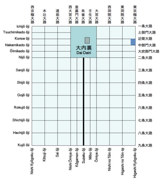
English: Schematic map of historical Heian-kyō (present-day Kyoto) showing the location of the Greater Imperial Palace (Daidairi) and the Tsuchimikado mansion.
Transferred from en.wikipedia to Commons. |
| ရက်စွဲ | ၁၉ မေ ၂၀၀၇ (original upload date) |
| ရင်းမြစ် |
Own work using:
|
| စာရေးသူ | Stca74 at အင်္ဂလိပ် ဝီကီပီးဒီးယား |
လိုင်စင်သတ်မှတ်ခြင်း
| This work has been released into the public domain by its author, Stca74 at အင်္ဂလိပ် ဝီကီပီးဒီးယား. This applies worldwide. In some countries this may not be legally possible; if so: Stca74 grants anyone the right to use this work for any purpose, without any conditions, unless such conditions are required by law. |
မူရင်းတင်ထားသောမှတ်တမ်း
ဖော်ပြချက် မူရင်းစာမျက်နှာမှာ here ဖြစ်သည်။ အောက်ပါအသုံးပြုသူ အမည်များအားလုံးသည် en.wikipedia ကို ရည်ညွှန်းသည်။
- 2007-05-19 09:17 Stca74 960×945×4 (9424 bytes) Schematic map of historical Heian-kyō (present-day Kyoto)showing the location of the Greater Imperial Palace (Daidairi) and the Tsuchimikado mansion. [[Category:Maps of the history of Japan]]
ဖိုင်မှတ်တမ်း
ဖိုင်ကို ယင်းနေ့စွဲ အတိုင်း မြင်နိုင်ရန် နေ့စွဲ/အချိန် တစ်ခုခုပေါ်တွင် ကလစ်နှိပ်ပါ။
| နေ့စွဲ/အချိန် | နမူနာပုံငယ် | မှတ်တမ်း ဒိုင်မန်းရှင်းများ | အသုံးပြုသူ | မှတ်ချက် | |
|---|---|---|---|---|---|
| ကာလပေါ် | ၀၂:၁၉၊ ၁၁ ဖေဖော်ဝါရီ ၂၀၂၃ | | ၉၁၀ × ၉၉၂ (၂၂၅ KB) | Firefangledfeathers | Cropped 23 % vertically using CropTool with precise mode. |
| ၁၀:၅၆၊ ၂၉ အောက်တိုဘာ ၂၀၂၂ |  | ၉၁၀ × ၁၂၈၆ (၂၇၄ KB) | Stca74 | Fixed modern palace location that had been lost in previous edit | |
| ၀၁:၂၉၊ ၈ ဇန်နဝါရီ ၂၀၁၉ |  | ၇၈၄ × ၈၈၆ (၁၁၄ KB) | 白拍子花子 | Corrected typo and refined typography | |
| ၁၄:၂၂၊ ၃၁ မေ ၂၀၀၇ |  | ၉၆၀ × ၉၄၅ (၉ KB) | うぃき野郎 | {{Information |Description=Schematic map of historical Heian-kyō (present-day Kyoto)showing the location of the Greater Imperial Palace (Daidairi) and the Tsuchimikado mansion. en:Category:Maps of the history of Japan |Source=Originally from [http: |
ဖိုင်သုံးစွဲမှု
အောက်ပါ စာမျက်နှာ သည် ဤဖိုင်ကို အသုံးပြုထားသည်:
ဂလိုဘယ် ဖိုင်သုံးစွဲမှု
အောက်ပါ အခြားဝီကီများတွင် ဤဖိုင်ကို အသုံးပြုထားသည်-
- ca.wikipedia.org တွင် အသုံးပြုမှု
- cs.wikipedia.org တွင် အသုံးပြုမှု
- de.wikipedia.org တွင် အသုံးပြုမှု
- en.wikipedia.org တွင် အသုံးပြုမှု
- es.wikipedia.org တွင် အသုံးပြုမှု
- fi.wikipedia.org တွင် အသုံးပြုမှု
- fr.wikipedia.org တွင် အသုံးပြုမှု
- hu.wikipedia.org တွင် အသုံးပြုမှု
- id.wikipedia.org တွင် အသုံးပြုမှု
- ja.wikipedia.org တွင် အသုံးပြုမှု
- ko.wikipedia.org တွင် အသုံးပြုမှု
- ms.wikipedia.org တွင် အသုံးပြုမှု
- pl.wikipedia.org တွင် အသုံးပြုမှု
- pt.wikipedia.org တွင် အသုံးပြုမှု
- ru.wikipedia.org တွင် အသုံးပြုမှု
- sl.wikipedia.org တွင် အသုံးပြုမှု
- th.wikipedia.org တွင် အသုံးပြုမှု
- tr.wikipedia.org တွင် အသုံးပြုမှု
- vi.wikipedia.org တွင် အသုံးပြုမှု
- zh.wikipedia.org တွင် အသုံးပြုမှု