
ဖိုင်:Control of the island of Borneo.png

ဤနမူနာ၏ အရွယ်အစား - ၅၃၉ × ၆၀၀ ပစ်ဇယ်။ အခြား ပုံရိပ်ပြတ်သားမှု: ၂၁၆ × ၂၄၀ ပစ်ဇယ် | ၄၃၁ × ၄၈၀ ပစ်ဇယ် | ၆၉၀ × ၇၆၈ ပစ်ဇယ် | ၁၀၈၀ × ၁၂၀၂ ပစ်ဇယ်။
မူရင်းဖိုင် (၁၀၈၀ × ၁၂၀၂ pixels, ဖိုင်အရွယ်အစား - ၂၀၇ KB, MIME အမျိုးအစား image/png)
| ဤဖိုင်သည် Wikimedia Commons မှဖြစ်ပြီး အခြားပရောဂျက်များတွင် သုံးကောင်းသုံးလိမ့်မည်။ ယင်း၏ ဖိုင်အကြောင်းစာမျက်နှာ တွင် ဖော်ပြထားချက်ကို အောက်တွင် ပြထားသည်။ Commons သည် မူပိုင်ခွင့်လွတ်လပ်သော မီဒီယာဖိုင်များ သိုလှောင်ထားရာ နေရာ ဖြစ်သည်။ သင်လည်း ပါဝင်ကူညီနိုင်ပါသည်။ |
အကျဉ်းချုပ်
| ဖော်ပြချက် |
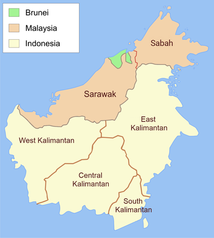
English: Administrative map of Borneo in English label. |
| ရက်စွဲ | |
| ရင်းမြစ် | ကိုယ်ပိုင်ဖန်တီးမှု, translate from File:Administrative map of Borneo (Indonesian).png |
| စာရေးသူ | Ranking Update |
| ခွင့်ပြုချက် (ဤဖိုင်ကို ပြန်လည်အသုံးပြုခြင်း) |
ကျွန်ုပ်၊ ဤလုပ်ဆောင်ချက်၏ မူပိုင်ခွင့်ပိုင်ရှင်အနေဖြင့် ဤနေရာမှ အောက်ပါလိုင်စင်အောက်တွင် ထုတ်လွှင့်ပါသည်: ဤဖိုင်ကို Creative Commons Attribution-Share Alike 3.0 Unported လိုင်စင်ဖြင့် သတ်မှတ်ထားသည်။
|
.png)

|
This map image could be re-created using vector graphics as an SVG file. This has several advantages; see Commons:Media for cleanup for more information. If an SVG form of this image is available, please upload it and afterwards replace this template with
{{vector version available|new image name}}.
It is recommended to name the SVG file “Control of the island of Borneo.svg”—then the template Vector version available (or Vva) does not need the new image name parameter. |
ဖိုင်မှတ်တမ်း
ဖိုင်ကို ယင်းနေ့စွဲ အတိုင်း မြင်နိုင်ရန် နေ့စွဲ/အချိန် တစ်ခုခုပေါ်တွင် ကလစ်နှိပ်ပါ။
| နေ့စွဲ/အချိန် | နမူနာပုံငယ် | မှတ်တမ်း ဒိုင်မန်းရှင်းများ | အသုံးပြုသူ | မှတ်ချက် | |
|---|---|---|---|---|---|
| ကာလပေါ် | ၁၀:၀၂၊ ၂၀ ဇူလိုင် ၂၀၂၁ | | ၁၀၈၀ × ၁၂၀၂ (၂၀၇ KB) | Davidelit | Reverted to version as of 09:57, 20 July 2021 (UTC) |
| ၁၀:၀၁၊ ၂၀ ဇူလိုင် ၂၀၂၁ |  | ၁၀၈၀ × ၁၂၀၂ (၂၃၂ KB) | Davidelit | Reverted to version as of 17:28, 4 August 2017 (UTC) | |
| ၀၉:၅၇၊ ၂၀ ဇူလိုင် ၂၀၂၁ |  | ၁၀၈၀ × ၁၂၀၂ (၂၀၇ KB) | Davidelit | Provinces as during the Confrontation, i.e. no North Kalimantan | |
| ၁၇:၂၈၊ ၄ ဩဂုတ် ၂၀၁၇ |  | ၁၀၈၀ × ၁၂၀၂ (၂၃၂ KB) | Night Lantern | fixed font | |
| ၂၀:၀၁၊ ၁၆ ဇူလိုင် ၂၀၁၇ |  | ၁၂၀၀ × ၁၃၃၅ (၁၄၆ KB) | Maproom | Updated name of northernmost province | |
| ၂၂:၀၃၊ ၁ ဩဂုတ် ၂၀၁၃ |  | ၁၂၀၀ × ၁၃၃၅ (၂၀၇ KB) | Muffin Wizard | User created page with UploadWizard |
ဖိုင်သုံးစွဲမှု
အောက်ပါ စာမျက်နှာ သည် ဤဖိုင်ကို အသုံးပြုထားသည်:
ဂလိုဘယ် ဖိုင်သုံးစွဲမှု
အောက်ပါ အခြားဝီကီများတွင် ဤဖိုင်ကို အသုံးပြုထားသည်-
- ar.wikipedia.org တွင် အသုံးပြုမှု
- bn.wikipedia.org တွင် အသုံးပြုမှု
- en.wikipedia.org တွင် အသုံးပြုမှု
- es.wikipedia.org တွင် အသုံးပြုမှု
- fr.wikipedia.org တွင် အသုံးပြုမှု
- incubator.wikimedia.org တွင် အသုံးပြုမှု
- it.wikipedia.org တွင် အသုံးပြုမှု
- ms.wikipedia.org တွင် အသုံးပြုမှု
- pcd.wikipedia.org တွင် အသုံးပြုမှု
- pt.wikipedia.org တွင် အသုံးပြုမှု
- sr.wikipedia.org တွင် အသုံးပြုမှု
- szy.wikipedia.org တွင် အသုံးပြုမှု
- vi.wikipedia.org တွင် အသုံးပြုမှု