
ဖိုင်:United Arab Emirates relief location map.jpg
ဤနမူနာ၏ အရွယ်အစား - ၆၉၈ × ၆၀၀ ပစ်ဇယ်။ အခြား ပုံရိပ်ပြတ်သားမှု: ၂၇၉ × ၂၄၀ ပစ်ဇယ် | ၅၅၉ × ၄၈၀ ပစ်ဇယ် | ၈၉၄ × ၇၆၈ ပစ်ဇယ် | ၁၂၂၈ × ၁၀၅၅ ပစ်ဇယ်။
မူရင်းဖိုင် (၁၂၂၈ × ၁၀၅၅ pixels, ဖိုင်အရွယ်အစား - ၆၆၈ KB, MIME အမျိုးအစား image/jpeg)
| ဤဖိုင်သည် Wikimedia Commons မှဖြစ်ပြီး အခြားပရောဂျက်များတွင် သုံးကောင်းသုံးလိမ့်မည်။ ယင်း၏ ဖိုင်အကြောင်းစာမျက်နှာ တွင် ဖော်ပြထားချက်ကို အောက်တွင် ပြထားသည်။ Commons သည် မူပိုင်ခွင့်လွတ်လပ်သော မီဒီယာဖိုင်များ သိုလှောင်ထားရာ နေရာ ဖြစ်သည်။ သင်လည်း ပါဝင်ကူညီနိုင်ပါသည်။ |
| ဖော်ပြချက် |
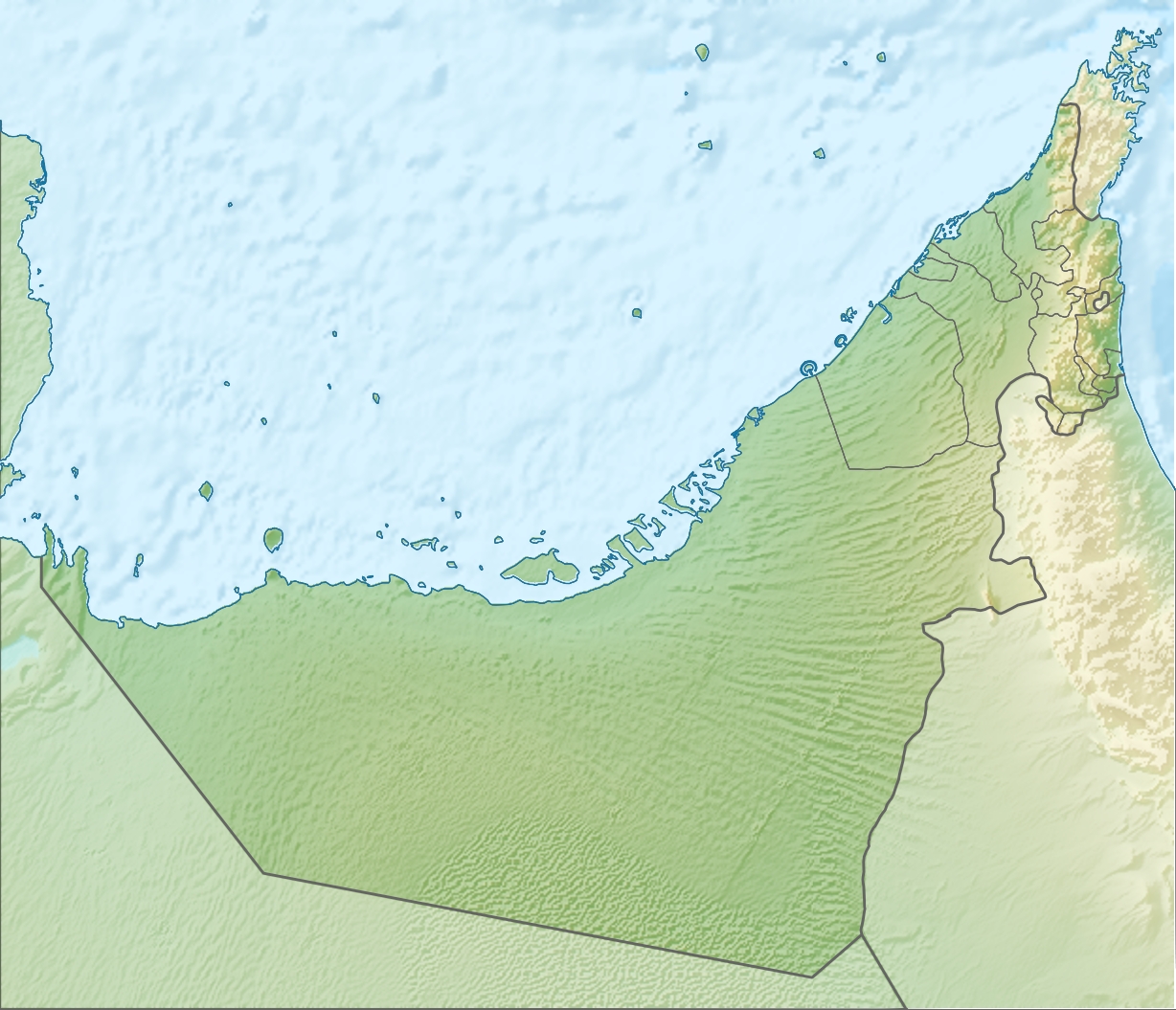
Deutsch: Positionskarte der Vereinigten Arabischen Emirate Quadratische Plattkarte, N-S-Streckung 109 %. Geographische Begrenzung der Karte: * N: 26.5° N * S: 22.4° N * W: 51.4° O * O: 56.6° O English: Location map of the United Arab Emirates Equirectangular projection, N/S stretching 109 %. Geographic limits of the map: * N: 26.5° N * S: 22.4° N * W: 51.4° E * E: 56.6° E |
| ရက်စွဲ | (UTC) |
| ရင်းမြစ် | |
| စာရေးသူ |
|
| အခြား ဗားရှင်းများ |
Derivative works of this file: Liwa oasis location.jpg
|

| This is a retouched picture, which means that it has been digitally altered from its original version. Modifications: relief map. The original can be viewed here: United Arab Emirates location map.svg:
|
ကျွန်ုပ်၊ ဤလုပ်ဆောင်ချက်၏ မူပိုင်ခွင့်ပိုင်ရှင်အနေဖြင့် ဤနေရာမှ အောက်ပါလိုင်စင်အောက်တွင် ထုတ်လွှင့်ပါသည်:
ဤဖိုင်ကို Creative Commons Attribution-Share Alike 3.0 Unported လိုင်စင်ဖြင့် သတ်မှတ်ထားသည်။
- သင်သည် လွတ်လပ်စွာ:
- မျှဝေရန် – ဖန်တီးမှုကို ကူးယူရန်၊ ဖြန့်ဖြူးရန်နှင့် ထုတ်လွှင့်ရန်
- ပြန်ရောနှောရန် – ဖန်တီးမှုကို ပြင်ဆင်ညှိနှိုင်းရန်
- အောက်ပါ အခြေအနေများတွင်:
- မှတ်ယူနိုင်ခြင်း – ပြောင်းလဲမှုများ ပြုလုပ်ခဲ့ပါက ဖန်တီးသူ သို့မဟုတ် လိုင်စင်ရှိသူမှ သတ်မှတ်သော အမျိုးအစားကို လိုက်နာရမည် (ဆိုလိုသည်မှာ သင့်အား သို့မဟုတ် သင့်ဖန်တီးမှုတွင် အသုံးပြုခြင်းအား ထောက်ခံချက်ပေးသည်ဟု မဆိုလိုပါ)။
- ထပ်တူမျှဝေ – ဤဖန်တီးမှုအား ပြင်ဆင်ခြင်း၊ ပြောင်းလဲခြင်း သို့မဟုတ် ထပ်ဆင့် ဖန်တီးခြင်း ပြုလုပ်ပါက ရရှိလာသော ဖန်တီးမှုကို ဤဖန်တီးမှုနှင့် သို့မဟုတ် ဆင်တူသော လိုင်စင်ဖြင့်သာ ဖြန့်ချိသင့်သည်။
မူရင်းတင်ထားသောမှတ်တမ်း
This image is a derivative work of the following images:
- File:United_Arab_Emirates_location_map.svg licensed with Cc-by-sa-3.0
- 2009-11-02T20:02:51Z NordNordWest 1228x1056 (243829 Bytes) '
- 2009-11-02T19:16:49Z NordNordWest 1228x1056 (244905 Bytes) {{int:filedesc}} {{Information |Description= {{de|Positionskarte der [[:de:Vereinigte Arabische Emirate|Vereinigten Arabischen Emirate]]}} Quadratische Plattkarte, N-S-Streckung 109 %. Geographische Begrenzung der Karte: * N:
Uploaded with derivativeFX
ဖိုင်မှတ်တမ်း
ဖိုင်ကို ယင်းနေ့စွဲ အတိုင်း မြင်နိုင်ရန် နေ့စွဲ/အချိန် တစ်ခုခုပေါ်တွင် ကလစ်နှိပ်ပါ။
| နေ့စွဲ/အချိန် | နမူနာပုံငယ် | မှတ်တမ်း ဒိုင်မန်းရှင်းများ | အသုံးပြုသူ | မှတ်ချက် | |
|---|---|---|---|---|---|
| ကာလပေါ် | ၀၉:၃၀၊ ၅ ဩဂုတ် ၂၀၁၀ | | ၁၂၂၈ × ၁၀၅၅ (၆၆၈ KB) | Uwe Dedering | {{Information |Description={{de|Positionskarte der Vereinigten Arabischen Emirate}} Quadratische Plattkarte, N-S-Streckung 109 %. Geographische Begrenzung der Karte: * N: 26.5° N * S: 22.4° N * W: 51.4° O * O: 56.6� |
ဖိုင်သုံးစွဲမှု
အောက်ပါ 3 စာမျက်နှာများ သည် ဤဖိုင်ကို အသုံးပြုထားသည်:
ဂလိုဘယ် ဖိုင်သုံးစွဲမှု
အောက်ပါ အခြားဝီကီများတွင် ဤဖိုင်ကို အသုံးပြုထားသည်-
- af.wikipedia.org တွင် အသုံးပြုမှု
- als.wikipedia.org တွင် အသုံးပြုမှု
- ar.wikipedia.org တွင် အသုံးပြုမှု
- ast.wikipedia.org တွင် အသုံးပြုမှု
- av.wikipedia.org တွင် အသုံးပြုမှု
- az.wikipedia.org တွင် အသုံးပြုမှု
- ba.wikipedia.org တွင် အသုံးပြုမှု
- be.wikipedia.org တွင် အသုံးပြုမှု
- bg.wikipedia.org တွင် အသုံးပြုမှု
- bh.wikipedia.org တွင် အသုံးပြုမှု
- bn.wikipedia.org တွင် အသုံးပြုမှု
- bs.wikipedia.org တွင် အသုံးပြုမှု
- bxr.wikipedia.org တွင် အသုံးပြုမှု
- ca.wikipedia.org တွင် အသုံးပြုမှု
- ceb.wikipedia.org တွင် အသုံးပြုမှု
- ce.wikipedia.org တွင် အသုံးပြုမှု
ဤဖိုင်ကို အခြားနေရာများတွင် အသုံးပြုထားမှုများအား ကြည့်ရှုရန်။