
ဖိုင်:ElectoralCollege1984.svg

မူရင်းဖိုင် (SVG ဖိုင်, ၁၀၂၀ × ၅၉၃ pixels ကို အကြံပြုသည်, ဖိုင်အရွယ်အစား - ၂၈ KB)
| ဤဖိုင်သည် Wikimedia Commons မှဖြစ်ပြီး အခြားပရောဂျက်များတွင် သုံးကောင်းသုံးလိမ့်မည်။ ယင်း၏ ဖိုင်အကြောင်းစာမျက်နှာ တွင် ဖော်ပြထားချက်ကို အောက်တွင် ပြထားသည်။ Commons သည် မူပိုင်ခွင့်လွတ်လပ်သော မီဒီယာဖိုင်များ သိုလှောင်ထားရာ နေရာ ဖြစ်သည်။ သင်လည်း ပါဝင်ကူညီနိုင်ပါသည်။ |
အကျဉ်းချုပ်
| ဖော်ပြချက် |
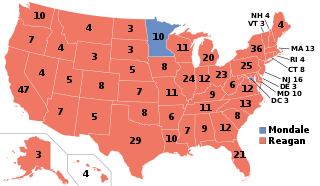
English: Electoral College results map for the 1984 United States presidential election between Ronald Reagan and Walter Mondale based on: https://www.archives.gov/electoral-college/1984 |
| ရက်စွဲ | |
| ရင်းမြစ် | ကိုယ်ပိုင်ဖန်တီးမှု |
| စာရေးသူ | SteveSims~commonswiki |
| U.S. presidential election maps (SVG) |
| See also: National Atlas maps (png) |
|
1789 · 1792 · 1796 · 1800 · 1804 · 1808 · 1812 · 1816 · 1820 · 1824 · 1828 · 1832 · 1836 · 1840 · 1844 · 1848 · 1852 · 1856 · 1860 · 1864 · 1868 · 1872 · 1876 · 1880 · 1884 · 1888 · 1892 · 1896 · 1900 · 1904 · 1908 · 1912 · 1916 · 1920 · 1924 · 1928 · 1932 · 1936 · 1940 · 1944 · 1948 · 1952 · 1956 · 1960 · 1964 · 1968 · 1972 · 1976 · 1980 · 1984 · 1988 · 1992 · 1996 · 2000 · 2004 · 2008 · 2012 · 2016 · 2020 · 2024 |
လိုင်စင်သတ်မှတ်ခြင်း
| I, the copyright holder of this work, release this work into the public domain. This applies worldwide. In some countries this may not be legally possible; if so: အကျွန်ုပ်သည် ဤဖန်တီးမှုလက်ရာကို ဥပဒေအရလိုအပ်ခြင်းမရှိသည့် မည်သည့်အခြေအနေမျိုးတွက်မဆို၊ မည်သို့သော ရည်ရွယ်ချက်အတွက်မဆို ၎င်းကို မည်သူမဆို အသုံးပြုပိုင်ခွင့်အား ပေးအပ်သည်။ |
ဖိုင်မှတ်တမ်း
ဖိုင်ကို ယင်းနေ့စွဲ အတိုင်း မြင်နိုင်ရန် နေ့စွဲ/အချိန် တစ်ခုခုပေါ်တွင် ကလစ်နှိပ်ပါ။
| နေ့စွဲ/အချိန် | နမူနာပုံငယ် | မှတ်တမ်း ဒိုင်မန်းရှင်းများ | အသုံးပြုသူ | မှတ်ချက် | |
|---|---|---|---|---|---|
| ကာလပေါ် | ၁၂:၅၀၊ ၂၈ ဒီဇင်ဘာ ၂၀၁၈ | | ၁၀၂၀ × ၅၉၃ (၂၈ KB) | Newfraferz87 | Optimize |
| ၁၁:၂၆၊ ၆ ဖေဖော်ဝါရီ ၂၀၁၇ |  | ၁၀၂၀ × ၅၉၃ (၃၄ KB) | Newfraferz87 | Clearer state borders | |
| ၁၆:၅၀၊ ၁၀ ဒီဇင်ဘာ ၂၀၁၆ |  | ၁၀၂၀ × ၅၉၃ (၃၅ KB) | WikiBunny2K1 | Updated map shape | |
| ၂၂:၃၀၊ ၁၄ ဇူလိုင် ၂၀၀၈ |  | ၁၀၂၀ × ၅၉၃ (၁၁၉ KB) | Noname224 | Fixed WV number | |
| ၂၂:၅၁၊ ၁၄ ဇွန် ၂၀၀၈ |  | ၁၀၂၀ × ၅၉၃ (၁၁၉ KB) | SteveSims~commonswiki | fixed error | |
| ၂၂:၄၉၊ ၁၄ ဇွန် ၂၀၀၈ |  | ၁၀၂၀ × ၅၉၃ (၁၁၉ KB) | SteveSims~commonswiki | == Summary == I created this image based on this map from the WikiMedia Commons: http://commons.wikimedia.org/wiki/Image:Blank_US_Map.svg It is in the public domain. == Licensing == {{PD-self}} |
ဖိုင်သုံးစွဲမှု
အောက်ပါ စာမျက်နှာ သည် ဤဖိုင်ကို အသုံးပြုထားသည်:
ဂလိုဘယ် ဖိုင်သုံးစွဲမှု
အောက်ပါ အခြားဝီကီများတွင် ဤဖိုင်ကို အသုံးပြုထားသည်-
- arz.wikipedia.org တွင် အသုံးပြုမှု
- bg.wikipedia.org တွင် အသုံးပြုမှု
- ca.wikipedia.org တွင် အသုံးပြုမှု
- cs.wikipedia.org တွင် အသုံးပြုမှု
- da.wikipedia.org တွင် အသုံးပြုမှု
- de.wikipedia.org တွင် အသုံးပြုမှု
- el.wikipedia.org တွင် အသုံးပြုမှု
- eml.wikipedia.org တွင် အသုံးပြုမှု
- en.wikipedia.org တွင် အသုံးပြုမှု
- Ronald Reagan
- 1984
- 1984 United States presidential election
- Presidency of Ronald Reagan
- Electoral vote changes between United States presidential elections
- Wikipedia:Reference desk/Archives/Humanities/2007 May 4
- List of United States presidential election results by state
- 1984 United States presidential election in Missouri
- Electoral history of George H. W. Bush
- Electoral history of Ronald Reagan
- Fifty-state strategy
- 1984 United States presidential election in California
- 1984 United States presidential election in Minnesota
- United States presidential election
- 1984 in the United States
- 1984 United States presidential election in Florida
- 1984 United States presidential election in North Carolina
- 1984 United States presidential election in Pennsylvania
- 1984 United States elections
- Template:State results of the 1984 U.S. presidential election
- 1984 United States presidential election in Montana
- 1984 United States presidential election in Maryland
- 1984 United States presidential election in New York
- Template:1984 United States presidential election imagemap
- 1984 United States presidential election in Vermont
- 1984 United States presidential election in New Mexico
- 1984 United States presidential election in Indiana
- 1984 United States presidential election in New Hampshire
- 1984 United States presidential election in Massachusetts
- 1984 United States presidential election in Alaska
- 1984 United States presidential election in New Jersey
- 1984 United States presidential election in Hawaii
- 1984 United States presidential election in Washington (state)
- 1984 United States presidential election in Oregon
- 1984 United States presidential election in Idaho
- 1984 United States presidential election in Nevada
- 1984 United States presidential election in Wyoming
- 1984 United States presidential election in Utah
- 1984 United States presidential election in Arizona
ဤဖိုင်ကို အခြားနေရာများတွင် အသုံးပြုထားမှုများအား ကြည့်ရှုရန်။