
ဖိုင်:A large blank world map with oceans marked in blue.PNG

ဤနမူနာ၏ အရွယ်အစား - ၈၀၀ × ၄၆၁ ပစ်ဇယ်။ အခြား ပုံရိပ်ပြတ်သားမှု: ၃၂၀ × ၁၈၄ ပစ်ဇယ် | ၆၄၀ × ၃၆၉ ပစ်ဇယ် | ၁၀၂၄ × ၅၉၀ ပစ်ဇယ် | ၁၂၈၀ × ၇၃၇ ပစ်ဇယ် | ၂၅၆၀ × ၁၄၇၅ ပစ်ဇယ် | ၄၅၀၀ × ၂၅၉၂ ပစ်ဇယ်။
မူရင်းဖိုင် (၄၅၀၀ × ၂၅၉၂ pixels, ဖိုင်အရွယ်အစား - ၂၃၃ KB, MIME အမျိုးအစား image/png)
| ဤဖိုင်သည် Wikimedia Commons မှဖြစ်ပြီး အခြားပရောဂျက်များတွင် သုံးကောင်းသုံးလိမ့်မည်။ ယင်း၏ ဖိုင်အကြောင်းစာမျက်နှာ တွင် ဖော်ပြထားချက်ကို အောက်တွင် ပြထားသည်။ Commons သည် မူပိုင်ခွင့်လွတ်လပ်သော မီဒီယာဖိုင်များ သိုလှောင်ထားရာ နေရာ ဖြစ်သည်။ သင်လည်း ပါဝင်ကူညီနိုင်ပါသည်။ |
အကျဉ်းချုပ်
Blank political world map derived from svg map
. It uses the Robinson projection.

|
File:A large blank world map with oceans marked in blue.svg is a vector version of this file. It should be used in place of this PNG file.
File:A large blank world map with oceans marked in blue.PNG → File:A large blank world map with oceans marked in blue.svg
For more information, see Help:SVG. |
 |
လိုင်စင်သတ်မှတ်ခြင်း
ကျွန်ုပ်၊ ဤလုပ်ဆောင်ချက်၏ မူပိုင်ခွင့်ပိုင်ရှင်အနေဖြင့် ဤနေရာမှ အောက်ပါလိုင်စင်များအောက်တွင် ထုတ်လွှင့်ပါသည်:

|
ဤစာတမ်းကို GNU Free Documentation License, ဗားရှင်း ၁.၂ သို့မဟုတ် Free Software Foundation မှ ဖြန့်ချီထားသော မည်သည့်ယခင်ဗားရှင်းတစ်ခုခုအောက်တွင် Invariant Sections, Front-Cover Texts နှင့် Back-Cover Texts များမပါဝင်ဘဲ ကူးယူခြင်း၊ ဖြန့်ချီခြင်း နှင့်/သို့မဟုတ် ပြင်ဆင်ပြောင်းလဲနိုင်ရန် ခွင့်ပြုသည်။ လိုင်စင်မူပွားကို GNU Free Documentation License ခေါင်းစဉ်အောက်တွင် ထည့်သွင်းထားသည်။ |
| ဤဖိုင်ကို Creative Commons Attribution-Share Alike 3.0 Unported လိုင်စင်ဖြင့် သတ်မှတ်ထားသည်။ | ||
| ||
| This licensing tag was added to this file as part of the GFDL licensing update. |
ဤဖိုင်သည် Creative Commons Attribution-Share Alike 2.5 Generic, 2.0 Generic and 1.0 Generic လိုင်စင်အောက်တွင် လိုင်စင်သတ်မှတ်ထားပါသည်။
- သင်သည် လွတ်လပ်စွာ:
- မျှဝေရန် – ဖန်တီးမှုကို ကူးယူရန်၊ ဖြန့်ဖြူးရန်နှင့် ထုတ်လွှင့်ရန်
- ပြန်ရောနှောရန် – ဖန်တီးမှုကို ပြင်ဆင်ညှိနှိုင်းရန်
- အောက်ပါ အခြေအနေများတွင်:
- မှတ်ယူနိုင်ခြင်း – ပြောင်းလဲမှုများ ပြုလုပ်ခဲ့ပါက ဖန်တီးသူ သို့မဟုတ် လိုင်စင်ရှိသူမှ သတ်မှတ်သော အမျိုးအစားကို လိုက်နာရမည် (ဆိုလိုသည်မှာ သင့်အား သို့မဟုတ် သင့်ဖန်တီးမှုတွင် အသုံးပြုခြင်းအား ထောက်ခံချက်ပေးသည်ဟု မဆိုလိုပါ)။
- ထပ်တူမျှဝေ – ဤဖန်တီးမှုအား ပြင်ဆင်ခြင်း၊ ပြောင်းလဲခြင်း သို့မဟုတ် ထပ်ဆင့် ဖန်တီးခြင်း ပြုလုပ်ပါက ရရှိလာသော ဖန်တီးမှုကို ဤဖန်တီးမှုနှင့် သို့မဟုတ် ဆင်တူသော လိုင်စင်ဖြင့်သာ ဖြန့်ချိသင့်သည်။
သင်အလိုရှိရာ လိုင်စင်ကို ရွေးချယ်နိုင်ပါသည်။
Derivative works
Derivative works of this file:
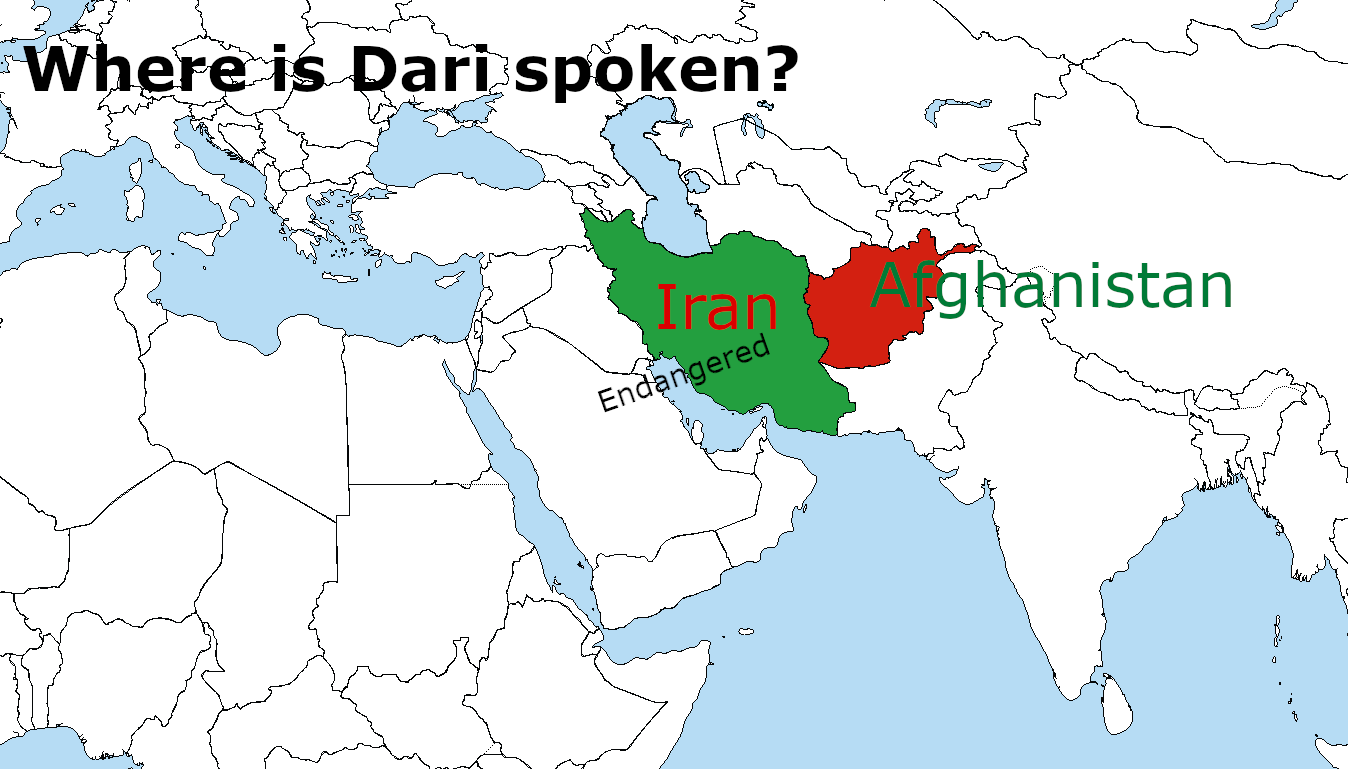
Derivative works of this file: Where is Dari Spoken? WhereisDariSpoken_MantraLingua.png
ဖိုင်မှတ်တမ်း
ဖိုင်ကို ယင်းနေ့စွဲ အတိုင်း မြင်နိုင်ရန် နေ့စွဲ/အချိန် တစ်ခုခုပေါ်တွင် ကလစ်နှိပ်ပါ။
| နေ့စွဲ/အချိန် | နမူနာပုံငယ် | မှတ်တမ်း ဒိုင်မန်းရှင်းများ | အသုံးပြုသူ | မှတ်ချက် | |
|---|---|---|---|---|---|
| ကာလပေါ် | ၁၈:၄၀၊ ၃ ဇွန် ၂၀၂၃ | | ၄၅၀၀ × ၂၅၉၂ (၂၃၃ KB) | DownwardSpiral1000 | The U.N. shows Donbass and Crimea as part of Ukraine, stop editing the map |
| ၁၉:၃၄၊ ၁၉ မေ ၂၀၂၃ |  | ၄၅၀၀ × ၂၅၈၃ (၁၈၉ KB) | Yann | Reverted to version as of 16:49, 17 May 2023 (UTC) | |
| ၀၁:၄၁၊ ၁၉ မေ ၂၀၂၃ |  | ၄၅၀၀ × ၂၅၉၂ (၂၃၃ KB) | PedroDuqueSantiago | Reverted to version as of 15:48, 14 May 2023 (UTC) | |
| ၁၆:၄၉၊ ၁၇ မေ ၂၀၂၃ |  | ၄၅၀၀ × ၂၅၈၃ (၁၈၉ KB) | JhonGame1 | Reverted to version as of 06:06, 13 May 2023 (UTC) | |
| ၁၅:၄၈၊ ၁၄ မေ ၂၀၂၃ |  | ၄၅၀၀ × ၂၅၉၂ (၂၃၃ KB) | Eurohunter | Reverted to version as of 11:53, 13 April 2023 (UTC) incorrect | |
| ၀၆:၀၆၊ ၁၃ မေ ၂၀၂၃ |  | ၄၅၀၀ × ၂၅၈၃ (၁၈၉ KB) | JhonGame1 | kosovo | |
| ၁၆:၀၈၊ ၁၂ မေ ၂၀၂၃ |  | ၄၅၀၀ × ၂၅၈၃ (၁၈၉ KB) | JhonGame1 | new borders | |
| ၁၁:၅၃၊ ၁၃ ဧပြီ ၂၀၂၃ |  | ၄၅၀၀ × ၂၅၉၂ (၂၃၃ KB) | MixoMiso27 | Reverted to version as of 10:11, 30 March 2014 (UTC) | |
| ၂၂:၁၆၊ ၁၀ ဧပြီ ၂၀၂၃ |  | ၄၅၀၀ × ၂၅၈၃ (၃၀၀ KB) | Forelie | Reverted to version as of 19:53, 23 March 2018 (UTC) | |
| ၁၇:၅၂၊ ၆ ဇွန် ၂၀၁၈ |  | ၄၅၀၀ × ၂၅၉၂ (၂၈၀ KB) | Cbrittain10 | Reverted to last version derived from the SVG. Please make corrections to the vector file before replacing the derived PNG. |
ဖိုင်သုံးစွဲမှု
ဤဖိုင်ကို အသုံးပြုထားသော စာမျက်နှာများမရှိပါ။
ဂလိုဘယ် ဖိုင်သုံးစွဲမှု
အောက်ပါ အခြားဝီကီများတွင် ဤဖိုင်ကို အသုံးပြုထားသည်-
- en.wikipedia.org တွင် အသုံးပြုမှု
- it.wikibooks.org တွင် အသုံးပြုမှု
- pt.wikipedia.org တွင် အသုံးပြုမှု