
ဖိုင်:Yanosteus longidorsalis MHNT (tighter crop).jpg

ဤနမူနာ၏ အရွယ်အစား - ၈၀၀ × ၃၁၆ ပစ်ဇယ်။ အခြား ပုံရိပ်ပြတ်သားမှု: ၃၂၀ × ၁၂၆ ပစ်ဇယ် | ၆၄၀ × ၂၅၃ ပစ်ဇယ် | ၁၀၂၄ × ၄၀၅ ပစ်ဇယ် | ၁၂၈၀ × ၅၀၆ ပစ်ဇယ် | ၂၅၆၀ × ၁၀၁၂ ပစ်ဇယ် | ၅၉၄၃ × ၂၃၄၉ ပစ်ဇယ်။
မူရင်းဖိုင် (၅၉၄၃ × ၂၃၄၉ pixels, ဖိုင်အရွယ်အစား - ၁၂.၁၄ MB, MIME အမျိုးအစား image/jpeg)
| ဤဖိုင်သည် Wikimedia Commons မှဖြစ်ပြီး အခြားပရောဂျက်များတွင် သုံးကောင်းသုံးလိမ့်မည်။ ယင်း၏ ဖိုင်အကြောင်းစာမျက်နှာ တွင် ဖော်ပြထားချက်ကို အောက်တွင် ပြထားသည်။ Commons သည် မူပိုင်ခွင့်လွတ်လပ်သော မီဒီယာဖိုင်များ သိုလှောင်ထားရာ နေရာ ဖြစ်သည်။ သင်လည်း ပါဝင်ကူညီနိုင်ပါသည်။ |
|
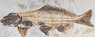
Yanosteus longidorsalis Jin et al. 1995 |
| Photographer | ||||||||||||||||||||||||
| ဖော်ပြချက် |
Deutsch: Yanosteus longidorsalis
English: Yanosteus longidorsalis
Français : Yanosteus longidorsalis
|
|||||||||||||||||||||||
| location of discovery | Deutsch: Yixian-Formation, Linyuan, Liaoning, China. English: Yixian Formation, Linyuan District, Liaoning, China. Français : Yixian Formation, District du Linyuan, Liaoning, Chine. |
|||||||||||||||||||||||
| ရက်စွဲ | ၁၁ ဒီဇင်ဘာ ၂၀၁၃ | |||||||||||||||||||||||
| စုဆောင်းမှု |
|
|||||||||||||||||||||||
| ရင်းမြစ် | ကိုယ်ပိုင်ဖန်တီးမှု | |||||||||||||||||||||||
| ခွင့်ပြုချက် (ဤဖိုင်ကို ပြန်လည်အသုံးပြုခြင်း) |
ကျွန်ုပ်၊ ဤလုပ်ဆောင်ချက်၏ မူပိုင်ခွင့်ပိုင်ရှင်အနေဖြင့် ဤနေရာမှ အောက်ပါလိုင်စင်အောက်တွင် ထုတ်လွှင့်ပါသည်: ဤဖိုင်သည် Creative Commons Attribution-Share Alike 4.0 နိုင်ငံတကာ လိုင်စင်အောက်တွင် လိုင်စင်သတ်မှတ်ထားပါသည်။
|
|||||||||||||||||||||||

.jpg)
| Camera location | | View this and other nearby images on: OpenStreetMap |
|---|
.jpg¶ms=043.818628_N_0001.408779_E_globe:Earth_type:camera__&language=my)

|
This document was made as part of the Projet Phoebus.
|
ဖိုင်မှတ်တမ်း
ဖိုင်ကို ယင်းနေ့စွဲ အတိုင်း မြင်နိုင်ရန် နေ့စွဲ/အချိန် တစ်ခုခုပေါ်တွင် ကလစ်နှိပ်ပါ။
| နေ့စွဲ/အချိန် | နမူနာပုံငယ် | မှတ်တမ်း ဒိုင်မန်းရှင်းများ | အသုံးပြုသူ | မှတ်ချက် | |
|---|---|---|---|---|---|
| ကာလပေါ် | ၁၉:၁၃၊ ၁၉ အောက်တိုဘာ ၂၀၂၂ | ၅၉၄၃ × ၂၃၄၉ (၁၂.၁၄ MB) | Hemiauchenia | Reverted to version as of 16:54, 19 October 2022 (UTC) Creates duplicate of pre-existing crop | |
| ၁၉:၀၀၊ ၁၉ အောက်တိုဘာ ၂၀၂၂ | ၆၇၀၈ × ၂၃၄၉ (၁၆.၈၆ MB) | Archaeodontosaurus | original version | ||
| ၁၆:၅၄၊ ၁၉ အောက်တိုဘာ ၂၀၂၂ | ၅၉၄၃ × ၂၃၄၉ (၁၂.၁၄ MB) | Hemiauchenia | File:Yanosteus longidorsalis MHNT (cropped).jpg cropped 11 % horizontally using CropTool with lossless mode. Okay, I'll just upload as a separate file then. The file is extremely long, which means that it gets shrunk down on Wikipedia, so I'm cropping the lateral dead space to make it appear bigger in thumb view |
.jpg)
ဖိုင်သုံးစွဲမှု
ဤဖိုင်ကို အသုံးပြုထားသော စာမျက်နှာများမရှိပါ။
ဂလိုဘယ် ဖိုင်သုံးစွဲမှု
အောက်ပါ အခြားဝီကီများတွင် ဤဖိုင်ကို အသုံးပြုထားသည်-
- en.wikipedia.org တွင် အသုံးပြုမှု
- es.wikipedia.org တွင် အသုံးပြုမှု
- ja.wikipedia.org တွင် အသုံးပြုမှု
.jpg)