
ဖိုင်:View from saana.JPG

ဤနမူနာ၏ အရွယ်အစား - ၈၀၀ × ၅၃၃ ပစ်ဇယ်။ အခြား ပုံရိပ်ပြတ်သားမှု: ၃၂၀ × ၂၁၃ ပစ်ဇယ် | ၆၄၀ × ၄၂၇ ပစ်ဇယ် | ၁၀၂၄ × ၆၈၃ ပစ်ဇယ် | ၁၂၈၀ × ၈၅၃ ပစ်ဇယ် | ၂၉၇၆ × ၁၉၈၄ ပစ်ဇယ်။
မူရင်းဖိုင် (၂၉၇၆ × ၁၉၈၄ pixels, ဖိုင်အရွယ်အစား - ၂.၃၈ MB, MIME အမျိုးအစား image/jpeg)
| ဤဖိုင်သည် Wikimedia Commons မှဖြစ်ပြီး အခြားပရောဂျက်များတွင် သုံးကောင်းသုံးလိမ့်မည်။ ယင်း၏ ဖိုင်အကြောင်းစာမျက်နှာ တွင် ဖော်ပြထားချက်ကို အောက်တွင် ပြထားသည်။ Commons သည် မူပိုင်ခွင့်လွတ်လပ်သော မီဒီယာဖိုင်များ သိုလှောင်ထားရာ နေရာ ဖြစ်သည်။ သင်လည်း ပါဝင်ကူညီနိုင်ပါသည်။ |
အကျဉ်းချုပ်
| ဖော်ပြချက် |
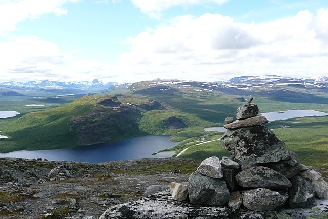
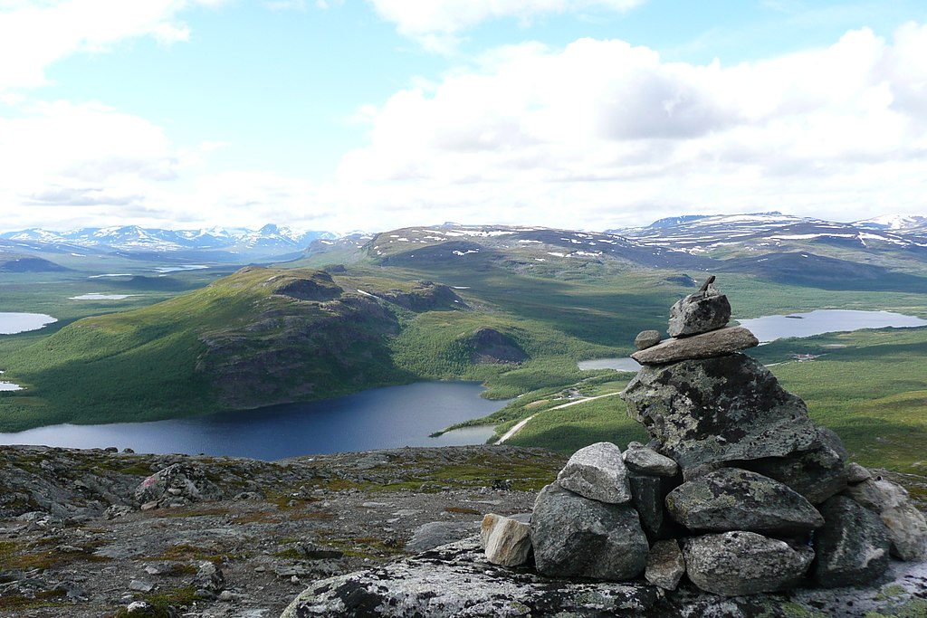
English: A view from Saana fell in the municipality of Enontekiö in Lapland, Finland. The stones on the right are one of the several stone stacks that the numerous visitors to Saana have gathered to the top of the fell. On the left a part of lake Kilpisjärvi is visible. The lake on the right is called Siilasjärvi. The closest fell in the picture is Pikku-Malla and behind that is Iso-Malla, both in the Malla Strict Nature Reserve.
Suomi: Näkymä Saanalta Enontekiön kunnassa Lapissa. Oikealla näkyvät kivet ovat yksi monista kivikasoista, jotka Saanan kävijät ovat koonneet tunturin huipulle. Vasemmalla kuvassa näkyy osa Kilpisjärvestä. Oikealla oleva järvi on Siilasjärvi. Lähin kuvassa oleva tunturi on Pikku-Malla ja sen takana on Iso-Malla, molemmat Mallan luonnonpuistossa. |
| ရက်စွဲ | |
| ရင်းမြစ် | ကိုယ်ပိုင်ဖန်တီးမှု |
| စာရေးသူ | Norppa |
| Camera location | | View this and other nearby images on: OpenStreetMap |
|---|
Accuracy of the camera location is about 100 m.
လိုင်စင်သတ်မှတ်ခြင်း
ကျွန်ုပ်၊ ဤလုပ်ဆောင်ချက်၏ မူပိုင်ခွင့်ပိုင်ရှင်အနေဖြင့် ဤနေရာမှ အောက်ပါလိုင်စင်များအောက်တွင် ထုတ်လွှင့်ပါသည်:

|
ဤစာတမ်းကို GNU Free Documentation License, ဗားရှင်း ၁.၂ သို့မဟုတ် Free Software Foundation မှ ဖြန့်ချီထားသော မည်သည့်ယခင်ဗားရှင်းတစ်ခုခုအောက်တွင် Invariant Sections, Front-Cover Texts နှင့် Back-Cover Texts များမပါဝင်ဘဲ ကူးယူခြင်း၊ ဖြန့်ချီခြင်း နှင့်/သို့မဟုတ် ပြင်ဆင်ပြောင်းလဲနိုင်ရန် ခွင့်ပြုသည်။ လိုင်စင်မူပွားကို GNU Free Documentation License ခေါင်းစဉ်အောက်တွင် ထည့်သွင်းထားသည်။ |
ဤဖိုင်သည် Creative Commons Attribution 3.0 Unported လိုင်စင်အောက်တွင် လိုင်စင်သတ်မှတ်ထားပါသည်။
- သင်သည် လွတ်လပ်စွာ:
- မျှဝေရန် – ဖန်တီးမှုကို ကူးယူရန်၊ ဖြန့်ဖြူးရန်နှင့် ထုတ်လွှင့်ရန်
- ပြန်ရောနှောရန် – ဖန်တီးမှုကို ပြင်ဆင်ညှိနှိုင်းရန်
- အောက်ပါ အခြေအနေများတွင်:
- မှတ်ယူနိုင်ခြင်း – ပြောင်းလဲမှုများ ပြုလုပ်ခဲ့ပါက ဖန်တီးသူ သို့မဟုတ် လိုင်စင်ရှိသူမှ သတ်မှတ်သော အမျိုးအစားကို လိုက်နာရမည် (ဆိုလိုသည်မှာ သင့်အား သို့မဟုတ် သင့်ဖန်တီးမှုတွင် အသုံးပြုခြင်းအား ထောက်ခံချက်ပေးသည်ဟု မဆိုလိုပါ)။
သင်အလိုရှိရာ လိုင်စင်ကို ရွေးချယ်နိုင်ပါသည်။
ဖိုင်မှတ်တမ်း
ဖိုင်ကို ယင်းနေ့စွဲ အတိုင်း မြင်နိုင်ရန် နေ့စွဲ/အချိန် တစ်ခုခုပေါ်တွင် ကလစ်နှိပ်ပါ။
| နေ့စွဲ/အချိန် | နမူနာပုံငယ် | မှတ်တမ်း ဒိုင်မန်းရှင်းများ | အသုံးပြုသူ | မှတ်ချက် | |
|---|---|---|---|---|---|
| ကာလပေါ် | ၁၂:၀၃၊ ၂၃ ဇူလိုင် ၂၀၀၈ | | ၂၉၇၆ × ၁၉၈၄ (၂.၃၈ MB) | Norppa | {{Information |Description={{en|1=A view from Saana fell in the municipality of Enontekiö in Lapland, Finland. The stones on the right are one of the several stone stacks that the numerous visitors to Saana have gathered to the top of the fell. On the le |
ဖိုင်သုံးစွဲမှု
ဤဖိုင်ကို အသုံးပြုထားသော စာမျက်နှာများမရှိပါ။
ဂလိုဘယ် ဖိုင်သုံးစွဲမှု
အောက်ပါ အခြားဝီကီများတွင် ဤဖိုင်ကို အသုံးပြုထားသည်-
- af.wikipedia.org တွင် အသုံးပြုမှု
- bn.wiktionary.org တွင် အသုံးပြုမှု
- ceb.wikipedia.org တွင် အသုံးပြုမှု
- de.wikipedia.org တွင် အသုံးပြုမှု
- en.wikipedia.org တွင် အသုံးပြုမှု
- en.wikivoyage.org တွင် အသုံးပြုမှု
- en.wiktionary.org တွင် အသုံးပြုမှု
- es.wikipedia.org တွင် အသုံးပြုမှု
- et.wikipedia.org တွင် အသုံးပြုမှု
- eu.wikipedia.org တွင် အသုံးပြုမှု
- Enontekiö
- Kilpisjärvi aintzira
- Mallako Natura Erreserba Hertsia
- Pöyrisjärvi (aintzira)
- Ounasjärvi
- Muotkajärvi aintzira
- Periläjärvi
- Enontekiöko babestutako eremuak
- Saana
- Ailakkajärvi
- Guoskatjávri
- Iso Salankijärvi
- Txantiloi:Enontekiö aintzirak
- Kelottijärvi aintzira
- Kalaton
- Kalatonjärvi
- Kaura
- Ketojärvi
- Lijankijärvi
- Kivijärvi aintzira
- Marsujärvi
- Marttajärvi
- Melajärvi
- Näkkäläjärvi
- Palojärvi aintzira
- Pasmajärvi (Enontekiö)
- Peltojärvi
- Somasjärvi
- Sotkajärvi
- Termisjärvi
- Tuolpajärvi
- Tuorkottajärvi
- Vuomajärvet
- Vuontisjärvi aintzira (Enontekiö)
- Iso Leveä
- Peerajärvi
- Ylimmäinen
ဤဖိုင်ကို အခြားနေရာများတွင် အသုံးပြုထားမှုများအား ကြည့်ရှုရန်။