
ဖိုင်:St James's Church, Manorbier - geograph.org.uk - 928738.jpg
သည်ထက်ကြီးသော resolution မရှိပါ.
St_James's_Church,_Manorbier_-_geograph.org.uk_-_928738.jpg (၆၄၀ × ၄၇၂ pixels, ဖိုင်အရွယ်အစား - ၇၅ KB, MIME အမျိုးအစား image/jpeg)
| ဤဖိုင်သည် Wikimedia Commons မှဖြစ်ပြီး အခြားပရောဂျက်များတွင် သုံးကောင်းသုံးလိမ့်မည်။ ယင်း၏ ဖိုင်အကြောင်းစာမျက်နှာ တွင် ဖော်ပြထားချက်ကို အောက်တွင် ပြထားသည်။ Commons သည် မူပိုင်ခွင့်လွတ်လပ်သော မီဒီယာဖိုင်များ သိုလှောင်ထားရာ နေရာ ဖြစ်သည်။ သင်လည်း ပါဝင်ကူညီနိုင်ပါသည်။ |
|
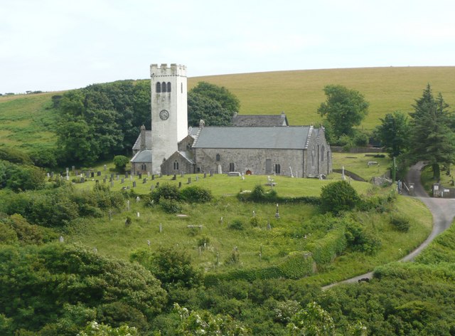
This is a photo of listed building number 5975. |
အကျဉ်းချုပ်
| ဖော်ပြချက် |
English: St James's Church, Manorbier 12C church restored by F Wehnert in 1865, when the rood screen was removed and the E window replaced by the present one. The entrance is via a vaulted porch with a medieval painting. The Norman nave has strong walls into which arches have been formed to the 14C aisles. The tower is in an unusual position in the angle between the chancel, rebuilt 13C, and the N transept. |
| ရက်စွဲ | |
| ရင်းမြစ် | From geograph.org.uk |
| စာရေးသူ | Humphrey Bolton |
| မှတ်ယူနိုင်ခြင်း (required by the license) | Humphrey Bolton / St James's Church, Manorbier / |
| Camera location | | View this and other nearby images on: OpenStreetMap |
|---|
_heading:157.00&language=my)
| Object location | | View this and other nearby images on: OpenStreetMap |
|---|
_heading:157.00&language=my)
လိုင်စင်သတ်မှတ်ခြင်း

|
This image was taken from the Geograph project collection. See this photograph's page on the Geograph website for the photographer's contact details. The copyright on this image is owned by Humphrey Bolton and is licensed for reuse under the Creative Commons Attribution-ShareAlike 2.0 license.
|
ဤဖိုင်သည် Creative Commons Attribution-Share Alike 2.0 Generic လိုင်စင်အောက်တွင် လိုင်စင်သတ်မှတ်ထားပါသည်။
မှတ်ယူနိုင်ခြင်း: Humphrey Bolton
- သင်သည် လွတ်လပ်စွာ:
- မျှဝေရန် – ဖန်တီးမှုကို ကူးယူရန်၊ ဖြန့်ဖြူးရန်နှင့် ထုတ်လွှင့်ရန်
- ပြန်ရောနှောရန် – ဖန်တီးမှုကို ပြင်ဆင်ညှိနှိုင်းရန်
- အောက်ပါ အခြေအနေများတွင်:
- မှတ်ယူနိုင်ခြင်း – ပြောင်းလဲမှုများ ပြုလုပ်ခဲ့ပါက ဖန်တီးသူ သို့မဟုတ် လိုင်စင်ရှိသူမှ သတ်မှတ်သော အမျိုးအစားကို လိုက်နာရမည် (ဆိုလိုသည်မှာ သင့်အား သို့မဟုတ် သင့်ဖန်တီးမှုတွင် အသုံးပြုခြင်းအား ထောက်ခံချက်ပေးသည်ဟု မဆိုလိုပါ)။
- ထပ်တူမျှဝေ – ဤဖန်တီးမှုအား ပြင်ဆင်ခြင်း၊ ပြောင်းလဲခြင်း သို့မဟုတ် ထပ်ဆင့် ဖန်တီးခြင်း ပြုလုပ်ပါက ရရှိလာသော ဖန်တီးမှုကို ဤဖန်တီးမှုနှင့် သို့မဟုတ် ဆင်တူသော လိုင်စင်ဖြင့်သာ ဖြန့်ချိသင့်သည်။
ဖိုင်မှတ်တမ်း
ဖိုင်ကို ယင်းနေ့စွဲ အတိုင်း မြင်နိုင်ရန် နေ့စွဲ/အချိန် တစ်ခုခုပေါ်တွင် ကလစ်နှိပ်ပါ။
| နေ့စွဲ/အချိန် | နမူနာပုံငယ် | မှတ်တမ်း ဒိုင်မန်းရှင်းများ | အသုံးပြုသူ | မှတ်ချက် | |
|---|---|---|---|---|---|
| ကာလပေါ် | ၀၄:၀၉၊ ၂၂ ဖေဖော်ဝါရီ ၂၀၁၁ | | ၆၄၀ × ၄၇၂ (၇၅ KB) | GeographBot | == {{int:filedesc}} == {{Information |description={{en|1=St James's Church, Manorbier 12C church restored by F Wehnert in 1865, when the rood screen was removed and the E window replaced by the present one. The entrance is via a vaulted porch with a medi |
ဖိုင်သုံးစွဲမှု
ဤဖိုင်ကို အသုံးပြုထားသော စာမျက်နှာများမရှိပါ။
ဂလိုဘယ် ဖိုင်သုံးစွဲမှု
အောက်ပါ အခြားဝီကီများတွင် ဤဖိုင်ကို အသုံးပြုထားသည်-
- arz.wikipedia.org တွင် အသုံးပြုမှု
- cy.wikipedia.org တွင် အသုံးပြုမှု
- en.wikipedia.org တွင် အသုံးပြုမှု
- fr.wikipedia.org တွင် အသုံးပြုမှု
- ru.wikipedia.org တွင် အသုံးပြုမှု
- www.wikidata.org တွင် အသုံးပြုမှု