
ဖိုင်:Sri Lanka geopolitics - after "Spoiling of Vijayabahu".png

မူရင်းဖိုင် (၂၄၄၁ × ၃၂၅၇ pixels, ဖိုင်အရွယ်အစား - ၅၇၅ KB, MIME အမျိုးအစား image/png)
| ဤဖိုင်သည် Wikimedia Commons မှဖြစ်ပြီး အခြားပရောဂျက်များတွင် သုံးကောင်းသုံးလိမ့်မည်။ ယင်း၏ ဖိုင်အကြောင်းစာမျက်နှာ တွင် ဖော်ပြထားချက်ကို အောက်တွင် ပြထားသည်။ Commons သည် မူပိုင်ခွင့်လွတ်လပ်သော မီဒီယာဖိုင်များ သိုလှောင်ထားရာ နေရာ ဖြစ်သည်။ သင်လည်း ပါဝင်ကူညီနိုင်ပါသည်။ |
အကျဉ်းချုပ်
| ဖော်ပြချက် |
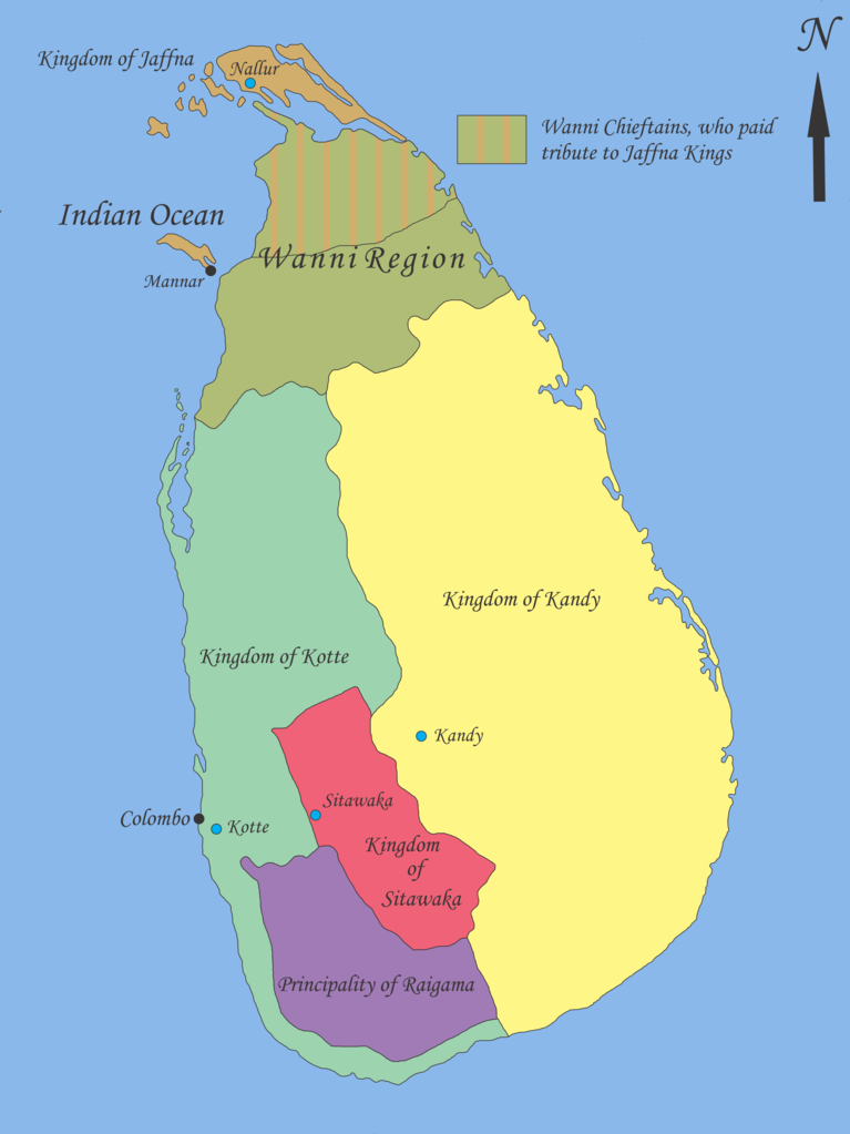
English: Map showing geopolitical situation in Sri Lanka in the early part of 16th century after the “Spoiling of Vijayabahu” in 1521. Map based on following sources;
- “Year 8 History Text Book – Government Publication”, THE ARRIVAL OF THE PORTUGUESE IN SRI LANKA: p14, 06th September 2012. -Fernao de Queyroz. The temporal and spiritual conquest of Ceylon. AES reprint. New Delhi: Asian Educational Services; 1995. p 47-58 ISBN 81-206-0765-1 -Captain Joao Ribeiro. The historic Tragedy of the island of Ceilao. AES Reprint. New Delhi: Asian Educational Services; 1999. p5 ISBN 81-206-1334-1 -Phillipus Baldaeus. A True and Exact Description of the Great Island of Ceylon. English Translation by Pieter Brohier. The Ceylon Historical Journal – Published in Co-operation with the Ceylon Branch of Royal Asiatic Society. Volume III, No 1-4; July 1958 to April 1959. p 300-301 Following maps were used to identify limitations of areas and not for the map itself. -DE L'ISLE:G. - Carte de l'Isle de Ceylan. Published in Paris 1723. http://www.swaen.com/antique-map-of.php?id=1777 , 06 September 2012 - VALENTIJN,F. - Nieuwe Kaart van het Eyland Ceylon opgestelt door. Published in Amsterdam 1724 http://www.swaen.com/antique-map-of.php?id=736 |
| ရက်စွဲ | |
| ရင်းမြစ် | ကိုယ်ပိုင်ဖန်တီးမှု |
| စာရေးသူ | Nishadhi |
လိုင်စင်သတ်မှတ်ခြင်း
- သင်သည် လွတ်လပ်စွာ:
- မျှဝေရန် – ဖန်တီးမှုကို ကူးယူရန်၊ ဖြန့်ဖြူးရန်နှင့် ထုတ်လွှင့်ရန်
- ပြန်ရောနှောရန် – ဖန်တီးမှုကို ပြင်ဆင်ညှိနှိုင်းရန်
- အောက်ပါ အခြေအနေများတွင်:
- မှတ်ယူနိုင်ခြင်း – ပြောင်းလဲမှုများ ပြုလုပ်ခဲ့ပါက ဖန်တီးသူ သို့မဟုတ် လိုင်စင်ရှိသူမှ သတ်မှတ်သော အမျိုးအစားကို လိုက်နာရမည် (ဆိုလိုသည်မှာ သင့်အား သို့မဟုတ် သင့်ဖန်တီးမှုတွင် အသုံးပြုခြင်းအား ထောက်ခံချက်ပေးသည်ဟု မဆိုလိုပါ)။
- ထပ်တူမျှဝေ – ဤဖန်တီးမှုအား ပြင်ဆင်ခြင်း၊ ပြောင်းလဲခြင်း သို့မဟုတ် ထပ်ဆင့် ဖန်တီးခြင်း ပြုလုပ်ပါက ရရှိလာသော ဖန်တီးမှုကို ဤဖန်တီးမှုနှင့် သို့မဟုတ် ဆင်တူသော လိုင်စင်ဖြင့်သာ ဖြန့်ချိသင့်သည်။

|
ဤစာတမ်းကို GNU Free Documentation License, ဗားရှင်း ၁.၂ သို့မဟုတ် Free Software Foundation မှ ဖြန့်ချီထားသော မည်သည့်ယခင်ဗားရှင်းတစ်ခုခုအောက်တွင် Invariant Sections, Front-Cover Texts နှင့် Back-Cover Texts များမပါဝင်ဘဲ ကူးယူခြင်း၊ ဖြန့်ချီခြင်း နှင့်/သို့မဟုတ် ပြင်ဆင်ပြောင်းလဲနိုင်ရန် ခွင့်ပြုသည်။ လိုင်စင်မူပွားကို GNU Free Documentation License ခေါင်းစဉ်အောက်တွင် ထည့်သွင်းထားသည်။ |
မူရင်းတင်ထားသောမှတ်တမ်း
- 2012-09-21 18:02 Nishadhi 2441×3257× (589067 bytes) Spelling mistake corrected.
- 2012-09-16 15:48 Nishadhi 2441×3257× (589023 bytes) Map showing geopolitical situation in Sri Lanka in the early part of 16th century after the “Spoiling of Vijayabahu” in 1521. Map based on following sources; - “Year 8 History Text Book – Government Publication”, THE ARRIVAL OF THE PORTUGUESE...
ဖိုင်မှတ်တမ်း
ဖိုင်ကို ယင်းနေ့စွဲ အတိုင်း မြင်နိုင်ရန် နေ့စွဲ/အချိန် တစ်ခုခုပေါ်တွင် ကလစ်နှိပ်ပါ။
| နေ့စွဲ/အချိန် | နမူနာပုံငယ် | မှတ်တမ်း ဒိုင်မန်းရှင်းများ | အသုံးပြုသူ | မှတ်ချက် | |
|---|---|---|---|---|---|
| ကာလပေါ် | ၁၉:၀၄၊ ၂၅ ဒီဇင်ဘာ ၂၀၁၄ | | ၂၄၄၁ × ၃၂၅၇ (၅၇၅ KB) | OgreBot | (BOT): Reverting to most recent version before archival |
| ၁၉:၀၄၊ ၂၅ ဒီဇင်ဘာ ၂၀၁၄ |  | ၂၄၄၁ × ၃၂၅၇ (၅၇၅ KB) | OgreBot | (BOT): Uploading old version of file from en.wikipedia; originally uploaded on 2012-09-16 15:48:39 by Nishadhi | |
| ၁၈:၂၅၊ ၂၁ စက်တင်ဘာ ၂၀၁၂ |  | ၂၄၄၁ × ၃၂၅၇ (၅၇၅ KB) | Nishadhi | {{Information |Description ={{en|1=Map showing geopolitical situation in Sri Lanka in the early part of 16th century after the “Spoiling of Vijayabahu” in 1521. Map based on following sources; - “Year 8 History Text Book – Government Public... |
ဖိုင်သုံးစွဲမှု
အောက်ပါ စာမျက်နှာ သည် ဤဖိုင်ကို အသုံးပြုထားသည်:
ဂလိုဘယ် ဖိုင်သုံးစွဲမှု
အောက်ပါ အခြားဝီကီများတွင် ဤဖိုင်ကို အသုံးပြုထားသည်-
- ca.wikipedia.org တွင် အသုံးပြုမှု
- de.wikipedia.org တွင် အသုံးပြုမှု
- en.wikipedia.org တွင် အသုံးပြုမှု
- Bayinnaung
- Kingdom of Kandy
- Vanni chieftaincies
- Vijayabā Kollaya
- Kingdom of Kotte
- User:Blackknight12/sandbox
- User:Nishadhi
- Siege of Kotte (1557–1558)
- Campaign of Danture
- Siege of Galle (1640)
- Sinhalese–Portuguese conflicts
- Sinhalese monarchy
- Transitional period of Sri Lanka
- User:Tisquesusa/sandbox9
- User:Blackknight12/sandbox2
- Myanmar–Sri Lanka relations
- fi.wikipedia.org တွင် အသုံးပြုမှု
- fr.wikipedia.org တွင် အသုံးပြုမှု
- it.wikipedia.org တွင် အသုံးပြုမှု
- ka.wikipedia.org တွင် အသုံးပြုမှု
- ko.wikipedia.org တွင် အသုံးပြုမှု
- nl.wikipedia.org တွင် အသုံးပြုမှု
- pl.wikipedia.org တွင် အသုံးပြုမှု
- pt.wikipedia.org တွင် အသုံးပြုမှု
- si.wikipedia.org တွင် အသုံးပြုမှု
- sl.wikipedia.org တွင် အသုံးပြုမှု
- ta.wikipedia.org တွင် အသုံးပြုမှု
- ur.wikipedia.org တွင် အသုံးပြုမှု
- zh.wikipedia.org တွင် အသုံးပြုမှု