
ဖိုင်:Spanish Empire Anachronous en.svg

Size of this PNG preview of this SVG file: ၈၀၀ × ၄၀၇ ပစ်ဇယ်. အခြား ပုံရိပ်ပြတ်သားမှု: ၃၂၀ × ၁၆၃ ပစ်ဇယ် | ၆၄၀ × ၃၂၅ ပစ်ဇယ် | ၁၀၂၄ × ၅၂၀ ပစ်ဇယ် | ၁၂၈၀ × ၆၅၀ ပစ်ဇယ် | ၂၅၆၀ × ၁၃၀၁ ပစ်ဇယ် | ၂၇၅၃ × ၁၃၉၉ ပစ်ဇယ်။
မူရင်းဖိုင် (SVG ဖိုင်, ၂၇၅၃ × ၁၃၉၉ pixels ကို အကြံပြုသည်, ဖိုင်အရွယ်အစား - ၁.၁၂ MB)
| ဤဖိုင်သည် Wikimedia Commons မှဖြစ်ပြီး အခြားပရောဂျက်များတွင် သုံးကောင်းသုံးလိမ့်မည်။ ယင်း၏ ဖိုင်အကြောင်းစာမျက်နှာ တွင် ဖော်ပြထားချက်ကို အောက်တွင် ပြထားသည်။ Commons သည် မူပိုင်ခွင့်လွတ်လပ်သော မီဒီယာဖိုင်များ သိုလှောင်ထားရာ နေရာ ဖြစ်သည်။ သင်လည်း ပါဝင်ကူညီနိုင်ပါသည်။ |
အကျဉ်းချုပ်
| ဖော်ပြချက် |
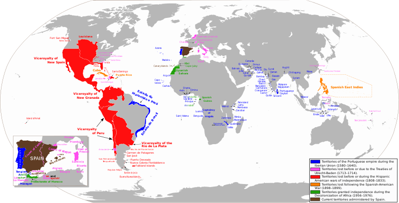
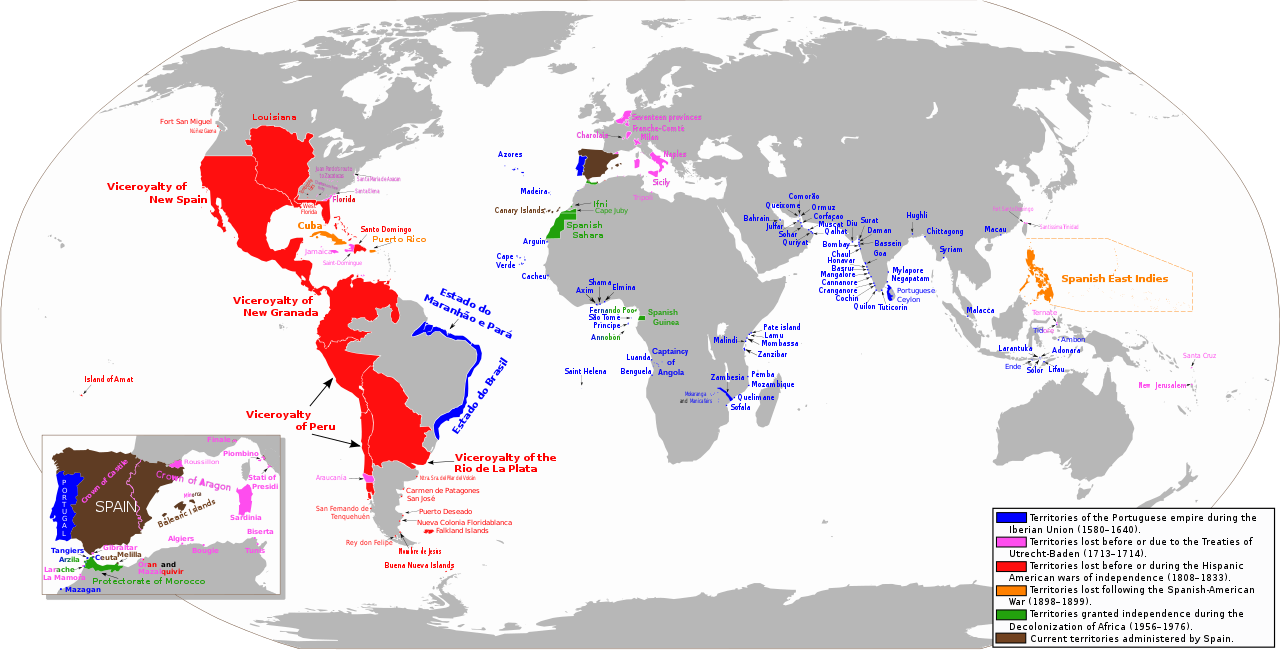
Español: Mapa diacrónico de los territorios del Imperio Español
Territorios del imperio portugués durante la Unión Ibérica (1580-1640)
Territorios hasta los Tratados de Utrecht-Baden (1713–1714)
Territorios hasta las Guerras de independencia hispanoamericana (1808–1833)
Territorios hasta la Guerra Hispano-Estadounidense (1898-1899)
Territorios hasta la Descolonización de África (1956-1976)
Territorios actualmente administrados por España English: Anachronous map of the Spanish Empire
Territories of the Portuguese empire during the Iberian Union (1580-1640)
Territories until the Treaties of Utrecht-Baden (1713–1714)
Territories until the Spanish American wars of independence (1808–1833)
Territories until the Spanish-American War (1898-1899)
Territories granted independence during the Decolonization of Africa (1956-1976)
Current territories administered by Spain |
| ရက်စွဲ | |
| ရင်းမြစ် | ကိုယ်ပိုင်ဖန်တီးမှု. View sources in talk page |
| စာရေးသူ | Trasamundo |
| ခွင့်ပြုချက် (ဤဖိုင်ကို ပြန်လည်အသုံးပြုခြင်း) |
trabajo propio (own work) |
| အခြား ဗားရှင်းများ |
 |
လိုင်စင်သတ်မှတ်ခြင်း
ကျွန်ုပ်၊ ဤလုပ်ဆောင်ချက်၏ မူပိုင်ခွင့်ပိုင်ရှင်အနေဖြင့် ဤနေရာမှ အောက်ပါလိုင်စင်များအောက်တွင် ထုတ်လွှင့်ပါသည်:

|
ဤစာတမ်းကို GNU Free Documentation License, ဗားရှင်း ၁.၂ သို့မဟုတ် Free Software Foundation မှ ဖြန့်ချီထားသော မည်သည့်ယခင်ဗားရှင်းတစ်ခုခုအောက်တွင် Invariant Sections, Front-Cover Texts နှင့် Back-Cover Texts များမပါဝင်ဘဲ ကူးယူခြင်း၊ ဖြန့်ချီခြင်း နှင့်/သို့မဟုတ် ပြင်ဆင်ပြောင်းလဲနိုင်ရန် ခွင့်ပြုသည်။ လိုင်စင်မူပွားကို GNU Free Documentation License ခေါင်းစဉ်အောက်တွင် ထည့်သွင်းထားသည်။ |
ဤဖိုင်သည် Creative Commons Attribution-Share Alike 3.0 Unported, 2.5 Generic, 2.0 Generic နှင့် 1.0 Generic လိုင်စင်အောက်တွင် လိုင်စင်သတ်မှတ်ထားပါသည်။
- သင်သည် လွတ်လပ်စွာ:
- မျှဝေရန် – ဖန်တီးမှုကို ကူးယူရန်၊ ဖြန့်ဖြူးရန်နှင့် ထုတ်လွှင့်ရန်
- ပြန်ရောနှောရန် – ဖန်တီးမှုကို ပြင်ဆင်ညှိနှိုင်းရန်
- အောက်ပါ အခြေအနေများတွင်:
- မှတ်ယူနိုင်ခြင်း – ပြောင်းလဲမှုများ ပြုလုပ်ခဲ့ပါက ဖန်တီးသူ သို့မဟုတ် လိုင်စင်ရှိသူမှ သတ်မှတ်သော အမျိုးအစားကို လိုက်နာရမည် (ဆိုလိုသည်မှာ သင့်အား သို့မဟုတ် သင့်ဖန်တီးမှုတွင် အသုံးပြုခြင်းအား ထောက်ခံချက်ပေးသည်ဟု မဆိုလိုပါ)။
- ထပ်တူမျှဝေ – ဤဖန်တီးမှုအား ပြင်ဆင်ခြင်း၊ ပြောင်းလဲခြင်း သို့မဟုတ် ထပ်ဆင့် ဖန်တီးခြင်း ပြုလုပ်ပါက ရရှိလာသော ဖန်တီးမှုကို ဤဖန်တီးမှုနှင့် သို့မဟုတ် ဆင်တူသော လိုင်စင်ဖြင့်သာ ဖြန့်ချိသင့်သည်။
သင်အလိုရှိရာ လိုင်စင်ကို ရွေးချယ်နိုင်ပါသည်။
ဖိုင်မှတ်တမ်း
ဖိုင်ကို ယင်းနေ့စွဲ အတိုင်း မြင်နိုင်ရန် နေ့စွဲ/အချိန် တစ်ခုခုပေါ်တွင် ကလစ်နှိပ်ပါ။
| နေ့စွဲ/အချိန် | နမူနာပုံငယ် | မှတ်တမ်း ဒိုင်မန်းရှင်းများ | အသုံးပြုသူ | မှတ်ချက် | |
|---|---|---|---|---|---|
| ကာလပေါ် | ၀၂:၁၅၊ ၁ မေ ၂၀၂၃ | | ၂၇၅၃ × ၁၃၉၉ (၁.၁၂ MB) | Janitoalevic | Fixed borders and added Araucanía |
| ၀၈:၅၇၊ ၂၄ ဧပြီ ၂၀၂၃ |  | ၂၇၅၃ × ၁၃၉၉ (၁.၀၁ MB) | Durero | Araucanía lost after mapuche rebelions. Restored previous version beacuse of borders | |
| ၁၆:၀၅၊ ၁၃ ဖေဖော်ဝါရီ ၂၀၂၃ |  | ၂၇၅၃ × ၁၃၉၉ (၁.၁၂ MB) | Janitoalevic | Added border between Chile and Perú, full Esequibo territory, Buena Nueva Islands and San Fernando de Tenquehuén. | |
| ၁၉:၂၅၊ ၂၇ နိုဝင်ဘာ ၂၀၁၉ |  | ၂၇၅၃ × ၁၃၉၉ (၁.၀၁ MB) | FDRMRZUSA | Corrected error (Siena) for "great" map too. In previous update the correction was restricted to the "little" map (box) on the lower left. No other changes. | |
| ၁၉:၀၀၊ ၂၇ နိုဝင်ဘာ ၂၀၁၉ |  | ၂၇၅၃ × ၁၃၉၉ (၁.၀၁ MB) | FDRMRZUSA | Restored version of 9 June 2013 (latest updated version) but with corrected mistake: Siena was part of the Granduchy of Tuscany. No other changes. | |
| ၁၈:၃၁၊ ၁၅ နိုဝင်ဘာ ၂၀၁၉ |  | ၂၇၅၃ × ၁၄၀၀ (၁.၃၇ MB) | Barjimoa | Reverted to version as of 18:53, 29 March 2009 (UTC) Correcting mistake: Siena was part of the Granduchy of Tuscany. | |
| ၂၁:၂၁၊ ၉ ဇွန် ၂၀၁၃ |  | ၂၇၅၃ × ၁၃၉၉ (၁.၃၃ MB) | Trasamundo | Oceanía | |
| ၁၉:၂၇၊ ၂၈ ဇန်နဝါရီ ၂၀၁၃ |  | ၂၇၅၃ × ၁၄၀၀ (၁.၅၃ MB) | Trasamundo | dates | |
| ၁၉:၅၁၊ ၆ စက်တင်ဘာ ၂၀၁၂ |  | ၂၇၅၃ × ၁၄၀၀ (၁.၄၉ MB) | Trasamundo | Iberian Peninsula | |
| ၂၁:၂၇၊ ၂၉ မတ် ၂၀၁၁ |  | ၂၇၅၃ × ၁၄၀၀ (၁.၅၂ MB) | Trasamundo | North Amarica: fixing the geographical accuracy, missions, forts |
ဖိုင်သုံးစွဲမှု
ဤဖိုင်ကို အသုံးပြုထားသော စာမျက်နှာများမရှိပါ။
ဂလိုဘယ် ဖိုင်သုံးစွဲမှု
အောက်ပါ အခြားဝီကီများတွင် ဤဖိုင်ကို အသုံးပြုထားသည်-
- azb.wikipedia.org တွင် အသုံးပြုမှု
- be.wikipedia.org တွင် အသုံးပြုမှု
- da.wikipedia.org တွင် အသုံးပြုမှု
- de.wikipedia.org တွင် အသုံးပြုမှု
- en.wikipedia.org တွင် အသုံးပြုမှု
- en.wikibooks.org တွင် အသုံးပြုမှု
- es.wikipedia.org တွင် အသုံးပြုမှု
- et.wikipedia.org တွင် အသုံးပြုမှု
- fr.wikipedia.org တွင် အသုံးပြုမှု
- gl.wikipedia.org တွင် အသုံးပြုမှု
- gn.wikipedia.org တွင် အသုံးပြုမှု
- he.wikipedia.org တွင် အသုံးပြုမှု
- hy.wikipedia.org တွင် အသုံးပြုမှု
- id.wikipedia.org တွင် အသုံးပြုမှု
- ko.wikipedia.org တွင် အသုံးပြုမှု
- lt.wikipedia.org တွင် အသုံးပြုမှု
ဤဖိုင်ကို အခြားနေရာများတွင် အသုံးပြုထားမှုများအား ကြည့်ရှုရန်။