
ဖိုင်:Sonar Principle EN.svg

Size of this PNG preview of this SVG file: ၄၉၆ × ၂၆၆ ပစ်ဇယ်. အခြား ပုံရိပ်ပြတ်သားမှု: ၃၂၀ × ၁၇၂ ပစ်ဇယ် | ၆၄၀ × ၃၄၃ ပစ်ဇယ် | ၁၀၂၄ × ၅၄၉ ပစ်ဇယ် | ၁၂၈၀ × ၆၈၆ ပစ်ဇယ် | ၂၅၆၀ × ၁၃၇၃ ပစ်ဇယ်။
မူရင်းဖိုင် (SVG ဖိုင်, ၄၉၆ × ၂၆၆ pixels ကို အကြံပြုသည်, ဖိုင်အရွယ်အစား - ၃၂ KB)
| ဤဖိုင်သည် Wikimedia Commons မှဖြစ်ပြီး အခြားပရောဂျက်များတွင် သုံးကောင်းသုံးလိမ့်မည်။ ယင်း၏ ဖိုင်အကြောင်းစာမျက်နှာ တွင် ဖော်ပြထားချက်ကို အောက်တွင် ပြထားသည်။ Commons သည် မူပိုင်ခွင့်လွတ်လပ်သော မီဒီယာဖိုင်များ သိုလှောင်ထားရာ နေရာ ဖြစ်သည်။ သင်လည်း ပါဝင်ကူညီနိုင်ပါသည်။ |
အကျဉ်းချုပ်
| ဖော်ပြချက် |
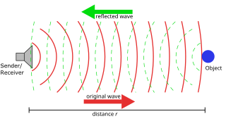
[] Català: Princip aktivního sonaru Čeština: Princip aktivního sonaru Deutsch: Prinzip der Sonar- oder Radarabstandsmessung English: Principle of a sonar or radar distance measurement Euskara: Radarraren funtzionamendua azaltzen duen irudia Français : Principe de mesure de la distance par sonar ou radar Hrvatski: Načelo rada sonara Svenska: Princip för avståndsmätning med sonar eller radar Македонски: Работа на сонарското или радарско мерење Русский: Принцип измерения расстояния сонаром или радаром العربية : رحلة الموجة السونارية أو الرادارية ذهابًا وإيابًا |
||
| ရက်စွဲ | |||
| ရင်းမြစ် | Self drawn with Inkscape | ||
| စာရေးသူ | Georg Wiora (Dr. Schorsch) | ||
| ခွင့်ပြုချက် (ဤဖိုင်ကို ပြန်လည်အသုံးပြုခြင်း) |
Dual licensing GFDL and CC-BY-SA-2.5 or newer | ||
| အခြား ဗားရှင်းများ |
Derivative works of this file: Sonar Principle ar.png
[] .png:
.svg:
|


|
This SVG file contains embedded text that can be translated into your language, using any capable SVG editor, text editor or the SVG Translate tool. For more information see: About translating SVG files. |
လိုင်စင်သတ်မှတ်ခြင်း
ကျွန်ုပ်၊ ဤလုပ်ဆောင်ချက်၏ မူပိုင်ခွင့်ပိုင်ရှင်အနေဖြင့် ဤနေရာမှ အောက်ပါလိုင်စင်များအောက်တွင် ထုတ်လွှင့်ပါသည်:

|
ဤစာတမ်းကို GNU Free Documentation License, ဗားရှင်း ၁.၂ သို့မဟုတ် Free Software Foundation မှ ဖြန့်ချီထားသော မည်သည့်ယခင်ဗားရှင်းတစ်ခုခုအောက်တွင် Invariant Sections, Front-Cover Texts နှင့် Back-Cover Texts များမပါဝင်ဘဲ ကူးယူခြင်း၊ ဖြန့်ချီခြင်း နှင့်/သို့မဟုတ် ပြင်ဆင်ပြောင်းလဲနိုင်ရန် ခွင့်ပြုသည်။ လိုင်စင်မူပွားကို GNU Free Documentation License ခေါင်းစဉ်အောက်တွင် ထည့်သွင်းထားသည်။ |
| ဤဖိုင်ကို Creative Commons Attribution-Share Alike 3.0 Unported လိုင်စင်ဖြင့် သတ်မှတ်ထားသည်။ | ||
| ||
| This licensing tag was added to this file as part of the GFDL licensing update. |
သင်အလိုရှိရာ လိုင်စင်ကို ရွေးချယ်နိုင်ပါသည်။
ဤဖိုင်သည် Creative Commons Attribution-Share Alike 2.5 Generic လိုင်စင်အောက်တွင် လိုင်စင်သတ်မှတ်ထားပါသည်။
- သင်သည် လွတ်လပ်စွာ:
- မျှဝေရန် – ဖန်တီးမှုကို ကူးယူရန်၊ ဖြန့်ဖြူးရန်နှင့် ထုတ်လွှင့်ရန်
- ပြန်ရောနှောရန် – ဖန်တီးမှုကို ပြင်ဆင်ညှိနှိုင်းရန်
- အောက်ပါ အခြေအနေများတွင်:
- မှတ်ယူနိုင်ခြင်း – ပြောင်းလဲမှုများ ပြုလုပ်ခဲ့ပါက ဖန်တီးသူ သို့မဟုတ် လိုင်စင်ရှိသူမှ သတ်မှတ်သော အမျိုးအစားကို လိုက်နာရမည် (ဆိုလိုသည်မှာ သင့်အား သို့မဟုတ် သင့်ဖန်တီးမှုတွင် အသုံးပြုခြင်းအား ထောက်ခံချက်ပေးသည်ဟု မဆိုလိုပါ)။
- ထပ်တူမျှဝေ – ဤဖန်တီးမှုအား ပြင်ဆင်ခြင်း၊ ပြောင်းလဲခြင်း သို့မဟုတ် ထပ်ဆင့် ဖန်တီးခြင်း ပြုလုပ်ပါက ရရှိလာသော ဖန်တီးမှုကို ဤဖန်တီးမှုနှင့် သို့မဟုတ် ဆင်တူသော လိုင်စင်ဖြင့်သာ ဖြန့်ချိသင့်သည်။
ဖိုင်မှတ်တမ်း
ဖိုင်ကို ယင်းနေ့စွဲ အတိုင်း မြင်နိုင်ရန် နေ့စွဲ/အချိန် တစ်ခုခုပေါ်တွင် ကလစ်နှိပ်ပါ။
| နေ့စွဲ/အချိန် | နမူနာပုံငယ် | မှတ်တမ်း ဒိုင်မန်းရှင်းများ | အသုံးပြုသူ | မှတ်ချက် | |
|---|---|---|---|---|---|
| ကာလပေါ် | ၁၁:၅၀၊ ၉ ဧပြီ ၂၀၀၈ | | ၄၉၆ × ၂၆၆ (၃၂ KB) | Webaware | == Beschreibung == {{Information| |Description = {{de|Prinzip der Sonar- oder Radarabstandsmessung}} {{en|Principle of a sonar or radar distance measurement - removed non-English text to prevent garbled PNG rendering}} {{cs|Princip aktivního sonaru}} |S |
| ၁၃:၅၃၊ ၁၈ စက်တင်ဘာ ၂၀၀၇ |  | ၄၉၆ × ၂၆၆ (၃၅ KB) | Wylve | made all objects to paths | |
| ၀၂:၃၄၊ ၂၀ နိုဝင်ဘာ ၂၀၀၆ |  | ၄၉၆ × ၂၆၆ (၂၃ KB) | Crisor | Recuperar una revisión anterior | |
| ၁၈:၁၂၊ ၃ အောက်တိုဘာ ၂၀၀၅ |  | ၄၉၆ × ၂၆၆ (၂၀ KB) | Xorx | Corrected text | |
| ၁၈:၀၁၊ ၃ အောက်တိုဘာ ၂၀၀၅ |  | ၄၉၆ × ၂၆၆ (၂၃ KB) | Xorx | {{Information| |Description = Principle of a sonar or radar distance measurement |Source = Self drawn with Inkscape |Date = created 3. Oct. 2005 |Author = Georg Wiora (~~~) |Permission = GFDL |other_versions = Version with german text [[:Image:Sonar_P |
ဖိုင်သုံးစွဲမှု
ဤဖိုင်ကို အသုံးပြုထားသော စာမျက်နှာများမရှိပါ။
ဂလိုဘယ် ဖိုင်သုံးစွဲမှု
အောက်ပါ အခြားဝီကီများတွင် ဤဖိုင်ကို အသုံးပြုထားသည်-
- bg.wikipedia.org တွင် အသုံးပြုမှု
- ca.wikipedia.org တွင် အသုံးပြုမှု
- cv.wikipedia.org တွင် အသုံးပြုမှု
- da.wikipedia.org တွင် အသုံးပြုမှု
- de.wikipedia.org တွင် အသုံးပြုမှု
- el.wikipedia.org တွင် အသုံးပြုမှု
- en.wikipedia.org တွင် အသုံးပြုမှု
- en.wikibooks.org တွင် အသုံးပြုမှု
- en.wiktionary.org တွင် အသုံးပြုမှု
- eo.wikipedia.org တွင် အသုံးပြုမှု
- fa.wikipedia.org တွင် အသုံးပြုမှု
- fy.wikipedia.org တွင် အသုံးပြုမှု
- gan.wikipedia.org တွင် အသုံးပြုမှု
- gl.wikipedia.org တွင် အသုံးပြုမှု
- he.wikipedia.org တွင် အသုံးပြုမှု
- he.wiktionary.org တွင် အသုံးပြုမှု
- hy.wikipedia.org တွင် အသုံးပြုမှု
- id.wikipedia.org တွင် အသုံးပြုမှု
- it.wikipedia.org တွင် အသုံးပြုမှု
- ja.wikipedia.org တွင် အသုံးပြုမှု
- kn.wikipedia.org တွင် အသုံးပြုမှု
- ko.wikipedia.org တွင် အသုံးပြုမှု
- lmo.wikipedia.org တွင် အသုံးပြုမှု
- ml.wikipedia.org တွင် အသုံးပြုမှု
- mn.wikipedia.org တွင် အသုံးပြုမှု
- mwl.wikipedia.org တွင် အသုံးပြုမှု
- nl.wikipedia.org တွင် အသုံးပြုမှု
- no.wikipedia.org တွင် အသုံးပြုမှု
- oc.wikipedia.org တွင် အသုံးပြုမှု
- pa.wikipedia.org တွင် အသုံးပြုမှု
- pl.wiktionary.org တွင် အသုံးပြုမှု
ဤဖိုင်ကို အခြားနေရာများတွင် အသုံးပြုထားမှုများအား ကြည့်ရှုရန်။