
ဖိုင်:Sani Pass heading into Lesotho.jpg

ဤနမူနာ၏ အရွယ်အစား - ၈၀၀ × ၅၃၂ ပစ်ဇယ်။ အခြား ပုံရိပ်ပြတ်သားမှု: ၃၂၀ × ၂၁၃ ပစ်ဇယ် | ၆၄၀ × ၄၂၅ ပစ်ဇယ် | ၁၀၂၄ × ၆၈၀ ပစ်ဇယ် | ၁၂၈၀ × ၈၅၀ ပစ်ဇယ် | ၁၆၀၀ × ၁၀၆၃ ပစ်ဇယ်။
မူရင်းဖိုင် (၁၆၀၀ × ၁၀၆၃ pixels, ဖိုင်အရွယ်အစား - ၂.၂၄ MB, MIME အမျိုးအစား image/jpeg)
| ဤဖိုင်သည် Wikimedia Commons မှဖြစ်ပြီး အခြားပရောဂျက်များတွင် သုံးကောင်းသုံးလိမ့်မည်။ ယင်း၏ ဖိုင်အကြောင်းစာမျက်နှာ တွင် ဖော်ပြထားချက်ကို အောက်တွင် ပြထားသည်။ Commons သည် မူပိုင်ခွင့်လွတ်လပ်သော မီဒီယာဖိုင်များ သိုလှောင်ထားရာ နေရာ ဖြစ်သည်။ သင်လည်း ပါဝင်ကူညီနိုင်ပါသည်။ |
အကျဉ်းချုပ်
| ဖော်ပြချက် |
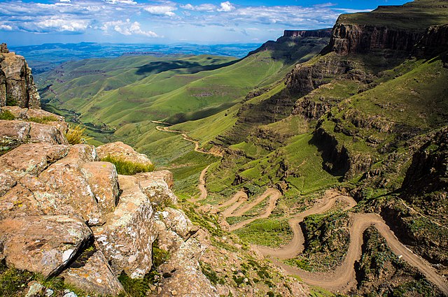
English: The road through Sani Pass taken from the rim of Drakensberg Escarpment within 100 metres of the South African/Lesotho border. |
| ရက်စွဲ | |
| ရင်းမြစ် | Flickr: Sani Pass |
| စာရေးသူ | Vaiz Ha |
| Camera location | | View this and other nearby images on: OpenStreetMap |
|---|
Geo-coords added by Martinvl after comparison of image with Google Earth.
လိုင်စင်သတ်မှတ်ခြင်း
| This image was originally posted to Flickr by Vaiz Ha at https://www.flickr.com/photos/93708644@N05/8523139565. It was reviewed on ၁၁ မတ် ၂၀၁၅ by FlickreviewR and was confirmed to be licensed under the terms of the cc-by-2.0. |
ဤဖိုင်သည် Creative Commons Attribution 2.0 Generic လိုင်စင်အောက်တွင် လိုင်စင်သတ်မှတ်ထားပါသည်။
မှတ်ယူနိုင်ခြင်း: Vaiz Ha
- သင်သည် လွတ်လပ်စွာ:
- မျှဝေရန် – ဖန်တီးမှုကို ကူးယူရန်၊ ဖြန့်ဖြူးရန်နှင့် ထုတ်လွှင့်ရန်
- ပြန်ရောနှောရန် – ဖန်တီးမှုကို ပြင်ဆင်ညှိနှိုင်းရန်
- အောက်ပါ အခြေအနေများတွင်:
- မှတ်ယူနိုင်ခြင်း – ပြောင်းလဲမှုများ ပြုလုပ်ခဲ့ပါက ဖန်တီးသူ သို့မဟုတ် လိုင်စင်ရှိသူမှ သတ်မှတ်သော အမျိုးအစားကို လိုက်နာရမည် (ဆိုလိုသည်မှာ သင့်အား သို့မဟုတ် သင့်ဖန်တီးမှုတွင် အသုံးပြုခြင်းအား ထောက်ခံချက်ပေးသည်ဟု မဆိုလိုပါ)။

|
This image has been assessed under the valued image criteria and is considered the most valued image on Commons within the scope: Road up the Sani Pass, South Africa heading towards the Lesotho border.. You can see its nomination here. |
ဖိုင်မှတ်တမ်း
ဖိုင်ကို ယင်းနေ့စွဲ အတိုင်း မြင်နိုင်ရန် နေ့စွဲ/အချိန် တစ်ခုခုပေါ်တွင် ကလစ်နှိပ်ပါ။
| နေ့စွဲ/အချိန် | နမူနာပုံငယ် | မှတ်တမ်း ဒိုင်မန်းရှင်းများ | အသုံးပြုသူ | မှတ်ချက် | |
|---|---|---|---|---|---|
| ကာလပေါ် | ၂၁:၂၄၊ ၁၁ မတ် ၂၀၁၅ | | ၁၆၀၀ × ၁၀၆၃ (၂.၂၄ MB) | Alifazal | User created page with UploadWizard |
ဖိုင်သုံးစွဲမှု
ဤဖိုင်ကို အသုံးပြုထားသော စာမျက်နှာများမရှိပါ။
ဂလိုဘယ် ဖိုင်သုံးစွဲမှု
အောက်ပါ အခြားဝီကီများတွင် ဤဖိုင်ကို အသုံးပြုထားသည်-
- af.wikipedia.org တွင် အသုံးပြုမှု
- bh.wikipedia.org တွင် အသုံးပြုမှု
- bn.wikipedia.org တွင် အသုံးပြုမှု
- ca.wikipedia.org တွင် အသုံးပြုမှု
- ceb.wikipedia.org တွင် အသုံးပြုမှု
- de.wikipedia.org တွင် အသုံးပြုမှု
- en.wikipedia.org တွင် အသုံးပြုမှု
- Mountain pass
- Sani Pass
- User talk:InfamousArgyle
- User talk:Mathwhiz 29
- User talk:Whiteghost.ink
- User talk:C6541/Archives
- User talk:Sahara4u
- User talk:Sarason
- User talk:Smileguy91
- User talk:Hypoplectrus
- User talk:Pratyya Ghosh
- User talk:Gwooodward
- User talk:Human3015
- User talk:Khamar
- User talk:Joshualouie711
- User talk:OfficialNeon
- User talk:Mozby
- User talk:MoarSmtp
- User talk:VictorTorres2002/Archive 3
- User talk:Mitchellhobbs/Archives/1
- User talk:TheDragonHypothesis
- User talk:Vanilla Wizard/Archive 1
- User talk:VictorTorres2002/Archive 5
- User talk:Esquivalience/Archive 15
- User talk:MusikAnimal/Archive 42
- User talk:ChamithN/Archive 32
- User talk:Winner 42/Archive 25
- User talk:Bananasoldier/Archive 9
- User talk:TruthToBeSpoken/Archive 6
- User talk:CAPTAIN RAJU/Archive 98
- User talk:K6ka/Archive 27
- User talk:Silver seren/Archive 25
- User talk:BabbaQ/Archive 11
- User talk:Mahensingha/Archive 54
- User talk:Sanskari/Archive 109
- User talk:KGirlTrucker81/Signpost/Archive 17
- User talk:Hhkohh/Archive 6
- User talk:7&6=thirteen/Archive 15
- User talk:NorthwestPassage/Archive 5
- Wikipedia talk:Articles for improvement/Archive 24
ဤဖိုင်ကို အခြားနေရာများတွင် အသုံးပြုထားမှုများအား ကြည့်ရှုရန်။