
ဖိုင်:SEUtahStrat.JPG

ဤနမူနာ၏ အရွယ်အစား - ၈၀၀ × ၄၅၄ ပစ်ဇယ်။ အခြား ပုံရိပ်ပြတ်သားမှု: ၃၂၀ × ၁၈၂ ပစ်ဇယ် | ၆၄၀ × ၃၆၃ ပစ်ဇယ် | ၁၀၂၄ × ၅၈၁ ပစ်ဇယ် | ၁၂၈၀ × ၇၂၆ ပစ်ဇယ် | ၃၁၆၁ × ၁၇၉၄ ပစ်ဇယ်။
မူရင်းဖိုင် (၃၁၆၁ × ၁၇၉၄ pixels, ဖိုင်အရွယ်အစား - ၂.၅ MB, MIME အမျိုးအစား image/jpeg)
| ဤဖိုင်သည် Wikimedia Commons မှဖြစ်ပြီး အခြားပရောဂျက်များတွင် သုံးကောင်းသုံးလိမ့်မည်။ ယင်း၏ ဖိုင်အကြောင်းစာမျက်နှာ တွင် ဖော်ပြထားချက်ကို အောက်တွင် ပြထားသည်။ Commons သည် မူပိုင်ခွင့်လွတ်လပ်သော မီဒီယာဖိုင်များ သိုလှောင်ထားရာ နေရာ ဖြစ်သည်။ သင်လည်း ပါဝင်ကူညီနိုင်ပါသည်။ |
အကျဉ်းချုပ်
| ဖော်ပြချက် |
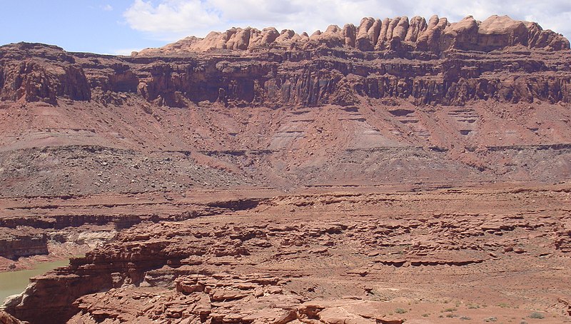
English: The Permian (bottom) through Jurassic (top) stratigraphy of the Colorado Plateau area of southeastern Utah that makes up much of the famous prominent rock formations in protected areas such as Capitol Reef National Park and Canyonlands National Park.
From top to bottom: Rounded tan domes of the Navajo Sandstone, layered red Kayenta Formation, cliff-forming, vertically-jointed, red Wingate Sandstone, slope-forming, purplish Chinle Formation, layered, lighter-red Moenkopi Formation, and white, layered Cutler Formation sandstone. Picture from Glen Canyon National Recreation Area, Utah. (modified version, 26MAY-2012, after change on en:Moenkopi Formation; changing (3) to a (3A,3B), with explanations, because of the larger photo RED debris visible.) The en:Jurassic through en:Permian stratigraphy of the Colorado Plateau area of southeastern Utah that makes up much of the famous prominent rock formations in protected areas such as Capitol Reef National Park and Canyonlands National Park. From top to bottom, (Jurassic to Permian): (6)-Rounded tan domes of the Navajo Sandstone, (5)-(very-dark)-layered red Kayenta Formation, (4)-(very-dark)-cliff-forming, vertically-jointed, red Wingate Sandstone, (3B)-(RED debris covered)-slope-forming, purplish Chinle Formation, (3A)-(NO RED Debris)-slope-forming, purplish Chinle Formation, (2)-layered, lighter-red Moenkopi Formation, and (1)-white, layered Cutler Formation sandstone. Picture from Glen Canyon National Recreation Area, Utah.)- (this makes 7 Layers, or there are 6 Layers with 3A, and 3B) |
| ရက်စွဲ | (UTC) (Uploaded on Commons at 2011-03-27 17:26:30 (UTC)/Original uploaded at 2010-05-20 16:46:26) |
| ရင်းမြစ် | I (Matt Affolter (QFL247) (talk)) created this work entirely by myself. (Original uploaded on en.wikipedia) |
| စာရေးသူ | Matt Affolter (QFL247) (talk) (Transferred by Citypeek/Original uploaded by Matt Affolter (QFL247)) |
လိုင်စင်သတ်မှတ်ခြင်း
Matt Affolter (QFL247)၊ ဤလုပ်ဆောင်ချက်၏ မူပိုင်ခွင့်ပိုင်ရှင်အနေဖြင့် ဤနေရာမှ အောက်ပါလိုင်စင်များအောက်တွင် ထုတ်လွှင့်ပါသည်:
ဤဖိုင်ကို Creative Commons Attribution-Share Alike 3.0 Unported လိုင်စင်ဖြင့် သတ်မှတ်ထားသည်။
မှတ်ယူနိုင်ခြင်း: Matt Affolter (QFL247)
- သင်သည် လွတ်လပ်စွာ:
- မျှဝေရန် – ဖန်တီးမှုကို ကူးယူရန်၊ ဖြန့်ဖြူးရန်နှင့် ထုတ်လွှင့်ရန်
- ပြန်ရောနှောရန် – ဖန်တီးမှုကို ပြင်ဆင်ညှိနှိုင်းရန်
- အောက်ပါ အခြေအနေများတွင်:
- မှတ်ယူနိုင်ခြင်း – ပြောင်းလဲမှုများ ပြုလုပ်ခဲ့ပါက ဖန်တီးသူ သို့မဟုတ် လိုင်စင်ရှိသူမှ သတ်မှတ်သော အမျိုးအစားကို လိုက်နာရမည် (ဆိုလိုသည်မှာ သင့်အား သို့မဟုတ် သင့်ဖန်တီးမှုတွင် အသုံးပြုခြင်းအား ထောက်ခံချက်ပေးသည်ဟု မဆိုလိုပါ)။
- ထပ်တူမျှဝေ – ဤဖန်တီးမှုအား ပြင်ဆင်ခြင်း၊ ပြောင်းလဲခြင်း သို့မဟုတ် ထပ်ဆင့် ဖန်တီးခြင်း ပြုလုပ်ပါက ရရှိလာသော ဖန်တီးမှုကို ဤဖန်တီးမှုနှင့် သို့မဟုတ် ဆင်တူသော လိုင်စင်ဖြင့်သာ ဖြန့်ချိသင့်သည်။

|
ဤစာတမ်းကို GNU Free Documentation License, ဗားရှင်း ၁.၂ သို့မဟုတ် Free Software Foundation မှ ဖြန့်ချီထားသော မည်သည့်ယခင်ဗားရှင်းတစ်ခုခုအောက်တွင် Invariant Sections, Front-Cover Texts နှင့် Back-Cover Texts များမပါဝင်ဘဲ ကူးယူခြင်း၊ ဖြန့်ချီခြင်း နှင့်/သို့မဟုတ် ပြင်ဆင်ပြောင်းလဲနိုင်ရန် ခွင့်ပြုသည်။ လိုင်စင်မူပွားကို GNU Free Documentation License ခေါင်းစဉ်အောက်တွင် ထည့်သွင်းထားသည်။ |
သင်အလိုရှိရာ လိုင်စင်ကို ရွေးချယ်နိုင်ပါသည်။
မူရင်းတင်ထားသောမှတ်တမ်း
ဖော်ပြချက် မူရင်းစာမျက်နှာမှာ here ဖြစ်သည်။ အောက်ပါအသုံးပြုသူ အမည်များအားလုံးသည် en.wikipedia ကို ရည်ညွှန်းသည်။
- 2010-05-20 16:46:26 Qfl247 3,161×1,794 (2.5 MB) ({{Information |Description = The [[Permian]] through [[Jurassic]] stratigraphy of the [[Colorado Plateau]] area of southeastern [[Utah]] that makes up much of the famous prominent rock formations in protected areas such as [[Capitol Reef National Park)
ဖိုင်မှတ်တမ်း
ဖိုင်ကို ယင်းနေ့စွဲ အတိုင်း မြင်နိုင်ရန် နေ့စွဲ/အချိန် တစ်ခုခုပေါ်တွင် ကလစ်နှိပ်ပါ။
| နေ့စွဲ/အချိန် | နမူနာပုံငယ် | မှတ်တမ်း ဒိုင်မန်းရှင်းများ | အသုံးပြုသူ | မှတ်ချက် | |
|---|---|---|---|---|---|
| ကာလပေါ် | ၁၇:၂၇၊ ၂၇ မတ် ၂၀၁၁ | | ၃၁၆၁ × ၁၇၉၄ (၂.၅ MB) | Citypeek | {{BotMoveToCommons|en.wikipedia|year={{subst:CURRENTYEAR}}|month={{subst:CURRENTMONTHNAME}}|day={{subst:CURRENTDAY}}}} The upload bot is User:CommonsHelper2 Bot which is called by [http://toolserver.org/~commonshelper2/index.php CommonsHelper2]. The t |
ဖိုင်သုံးစွဲမှု
ဤဖိုင်ကို အသုံးပြုထားသော စာမျက်နှာများမရှိပါ။
ဂလိုဘယ် ဖိုင်သုံးစွဲမှု
အောက်ပါ အခြားဝီကီများတွင် ဤဖိုင်ကို အသုံးပြုထားသည်-
- ar.wikipedia.org တွင် အသုံးပြုမှု
- be-tarask.wikipedia.org တွင် အသုံးပြုမှု
- bg.wikipedia.org တွင် အသုံးပြုမှု
- bs.wikipedia.org တွင် အသုံးပြုမှု
- ca.wikipedia.org တွင် အသုံးပြုမှု
- cs.wikipedia.org တွင် အသုံးပြုမှု
- de.wikipedia.org တွင် အသုံးပြုမှု
- en.wikipedia.org တွင် အသုံးပြုမှု
- Geology
- Sedimentary rock
- Stratigraphy
- Lithology
- Stratum
- Colorado Plateau
- Grand Staircase
- Glen Canyon National Recreation Area
- Geological formation
- Geology of the Canyonlands area
- Geology of the Capitol Reef area
- Stratigraphic unit
- Lithostratigraphy
- Principle of original horizontality
- Relative dating
- Navajo Sandstone
- Moenkopi Formation
- Chinle Formation
- Glen Canyon Group
- Wingate Sandstone
- Kayenta Formation
- Principle of lateral continuity
- Stratigraphic section
- User:Qfl247/pics
- User:Rygel, M.C./SedimentaryRock Sandbox
- User:Abyssal/Portal:Permian/Natural world articles/33
- User:Abyssal/Portal:Triassic/Natural world articles/32
- User:Abyssal/Portal:Jurassic/Natural world articles/31
- User:Abyssal/Portal:Paleogene/Natural world articles/33
- User:Abyssal/Portal:Cenozoic/Natural world articles/33
ဤဖိုင်ကို အခြားနေရာများတွင် အသုံးပြုထားမှုများအား ကြည့်ရှုရန်။