
ဖိုင်:Roman Empire with dioceses in 300 AD.png
ဤနမူနာ၏ အရွယ်အစား - ၈၀၀ × ၅၅၂ ပစ်ဇယ်။ အခြား ပုံရိပ်ပြတ်သားမှု: ၃၂၀ × ၂၂၁ ပစ်ဇယ် | ၆၄၀ × ၄၄၁ ပစ်ဇယ် | ၁၀၂၄ × ၇၀၆ ပစ်ဇယ် | ၁၂၈၀ × ၈၈၃ ပစ်ဇယ် | ၂၀၅၂ × ၁၄၁၅ ပစ်ဇယ်။
မူရင်းဖိုင် (၂၀၅၂ × ၁၄၁၅ pixels, ဖိုင်အရွယ်အစား - ၂၁၃ KB, MIME အမျိုးအစား image/png)
| ဤဖိုင်သည် Wikimedia Commons မှဖြစ်ပြီး အခြားပရောဂျက်များတွင် သုံးကောင်းသုံးလိမ့်မည်။ ယင်း၏ ဖိုင်အကြောင်းစာမျက်နှာ တွင် ဖော်ပြထားချက်ကို အောက်တွင် ပြထားသည်။ Commons သည် မူပိုင်ခွင့်လွတ်လပ်သော မီဒီယာဖိုင်များ သိုလှောင်ထားရာ နေရာ ဖြစ်သည်။ သင်လည်း ပါဝင်ကူညီနိုင်ပါသည်။ |

|
This map image could be re-created using vector graphics as an SVG file. This has several advantages; see Commons:Media for cleanup for more information. If an SVG form of this image is available, please upload it and afterwards replace this template with
{{vector version available|new image name}}.
It is recommended to name the SVG file “Roman Empire with dioceses in 300 AD.svg”—then the template Vector version available (or Vva) does not need the new image name parameter. |
အကျဉ်းချုပ်
| ဖော်ပြချက် |
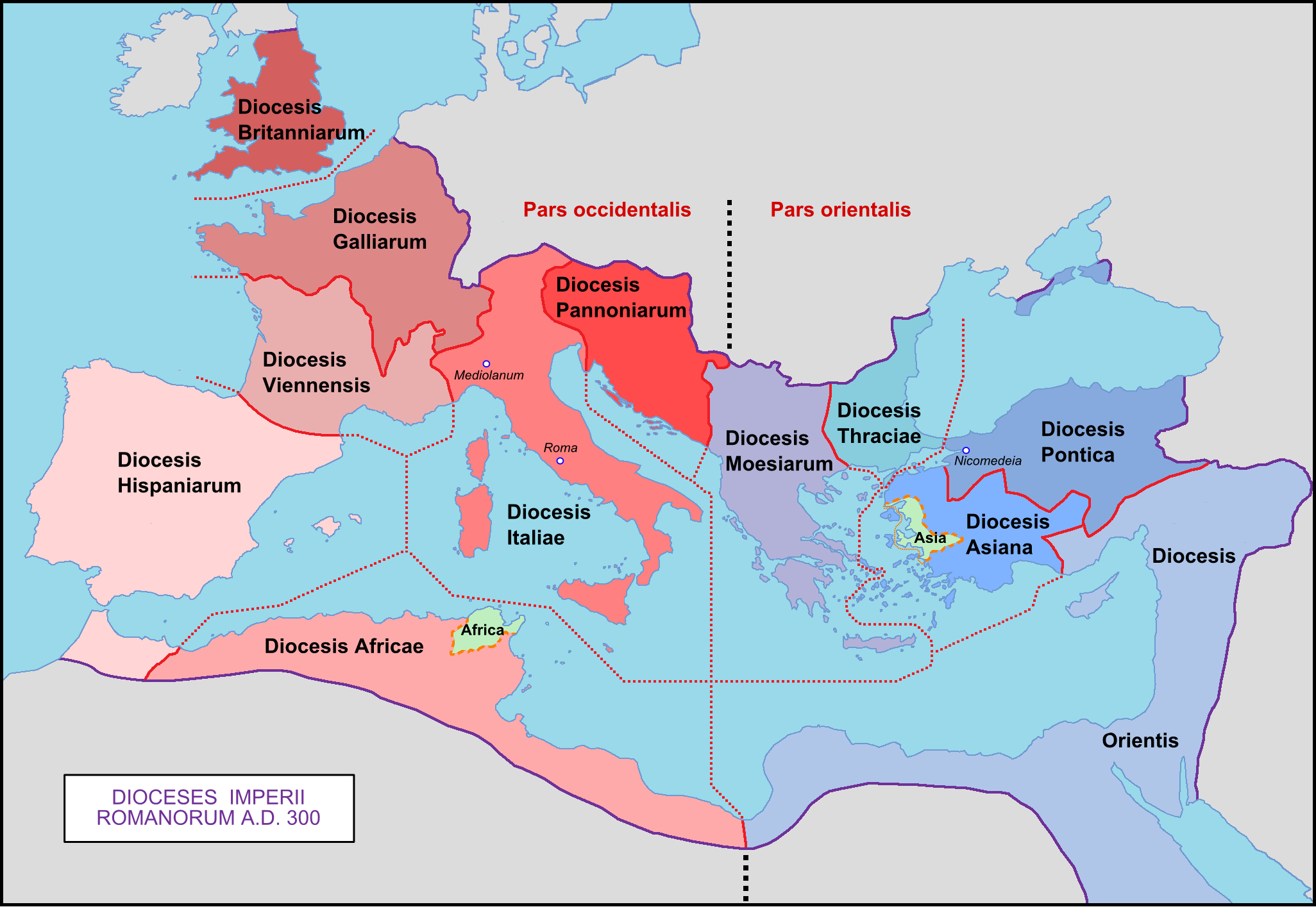
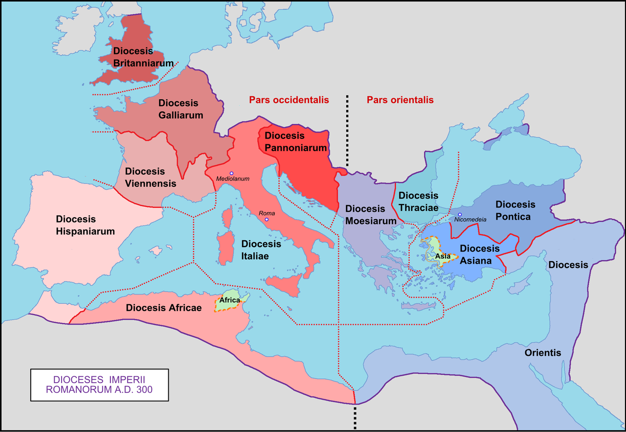
English: Map of the Roman Empire with dioceses created by Diocletien.
Français : Carte de l'Empire romain avec les diocèses créés par l'empereur Dioclétien. |
| ရက်စွဲ | 03/03/09 |
| ရင်းမြစ် | ကိုယ်ပိုင်ဖန်တီးမှု |
| စာရေးသူ | Mandrak |
| အခြား ဗားရှင်းများ |
Derivative works of this file: Prima tetrarchia Diocletianus.PNG Blank map : File:Blank Roman Empire.png []
|


လိုင်စင်သတ်မှတ်ခြင်း
| I, the copyright holder of this work, release this work into the public domain. This applies worldwide. In some countries this may not be legally possible; if so: အကျွန်ုပ်သည် ဤဖန်တီးမှုလက်ရာကို ဥပဒေအရလိုအပ်ခြင်းမရှိသည့် မည်သည့်အခြေအနေမျိုးတွက်မဆို၊ မည်သို့သော ရည်ရွယ်ချက်အတွက်မဆို ၎င်းကို မည်သူမဆို အသုံးပြုပိုင်ခွင့်အား ပေးအပ်သည်။ |
ဖိုင်မှတ်တမ်း
ဖိုင်ကို ယင်းနေ့စွဲ အတိုင်း မြင်နိုင်ရန် နေ့စွဲ/အချိန် တစ်ခုခုပေါ်တွင် ကလစ်နှိပ်ပါ။
| နေ့စွဲ/အချိန် | နမူနာပုံငယ် | မှတ်တမ်း ဒိုင်မန်းရှင်းများ | အသုံးပြုသူ | မှတ်ချက် | |
|---|---|---|---|---|---|
| ကာလပေါ် | ၀၀:၂၉၊ ၈ ဧပြီ ၂၀၂၀ | | ၂၀၅၂ × ၁၄၁၅ (၂၁၃ KB) | Wikisaurus | without bottom part, because it was wrong to rewrite a file used in many articles like this |
| ၁၂:၂၆၊ ၂၉ နိုဝင်ဘာ ၂၀၁၉ |  | ၂၀၅၂ × ၂၈၃၀ (၃၄၄ KB) | Claude Zygiel | Cosmetics, Chersonesos, details according with http://www.tuttitemi.altervista.org/Storia/StoriaA/DioclezianoRomolo.htm | |
| ၁၅:၅၄၊ ၂၂ နိုဝင်ဘာ ၂၀၁၉ |  | ၂၀၅၂ × ၂၈၃၀ (၃၀၇ KB) | Claude Zygiel | Add below praefecturae year 395 according with Megistias's map [https://commons.wikimedia.org/wiki/File:Praetorian_Prefectures_of_the_Roman_Empire_395_AD.png] | |
| ၁၂:၃၄၊ ၁၀ မတ် ၂၀၀၉ |  | ၂၀၅၂ × ၁၄၁၄ (၂၁၈ KB) | Mandrak | Erreurs corrigées. | |
| ၂၀:၀၃၊ ၃ မတ် ၂၀၀၉ |  | ၂၀၅၂ × ၁၄၁၄ (၂၁၈ KB) | Mandrak | {{Information |Description={{en|1=Map of the Roman Empire with dioceses created by Diocletien.}} {{fr|1=Carte de l'Empire romain avec les diocèses créés par l'empereur Dioclétien.}} |Source=travail personnel (own work) |Author=Mandrak |
ဖိုင်သုံးစွဲမှု
ဤဖိုင်ကို အသုံးပြုထားသော စာမျက်နှာများမရှိပါ။
ဂလိုဘယ် ဖိုင်သုံးစွဲမှု
အောက်ပါ အခြားဝီကီများတွင် ဤဖိုင်ကို အသုံးပြုထားသည်-
- ar.wikipedia.org တွင် အသုံးပြုမှု
- ast.wikipedia.org တွင် အသုံးပြုမှု
- az.wikipedia.org တွင် အသုံးပြုမှု
- bg.wikipedia.org တွင် အသုံးပြုမှု
- ca.wikipedia.org တွင် အသုံးပြုမှု
- cs.wikipedia.org တွင် အသုံးပြုမှု
- de.wikipedia.org တွင် အသုံးပြုမှု
- 300
- Konstantin der Große
- Moesia inferior
- Dioecesis Orientis
- Dioecesis Pontica
- Dioecesis Asiana
- Dioecesis Thraciarum
- Dioecesis Moesiae
- Dioecesis Pannoniae
- Vorlage:Navigationsleiste Diözesen des Römischen Reiches
- Dioecesis Africae
- Dioecesis Britanniae
- Dioecesis Galliae
- Dioecesis Septem Provinciarum
- Dioecesis Aegypti
- Dioecesis Hispaniae
- Dioecesis Italiae
- Dioecesis Italiae Annonariae
- Dioecesis Italiae Suburbicariae
- Dioecesis Daciae
- Dioecesis Macedoniae
- el.wikipedia.org တွင် အသုံးပြုမှု
- en.wikipedia.org တွင် အသုံးပြုမှု
- eo.wikipedia.org တွင် အသုံးပြုမှု
ဤဖိုင်ကို အခြားနေရာများတွင် အသုံးပြုထားမှုများအား ကြည့်ရှုရန်။