
ဖိုင်:Railway map of Myanmar.png
ဤနမူနာ၏ အရွယ်အစား - ၃၉၃ × ၆၀၀ ပစ်ဇယ်။ အခြား ပုံရိပ်ပြတ်သားမှု: ၁၅၇ × ၂၄၀ ပစ်ဇယ် | ၃၁၄ × ၄၈၀ ပစ်ဇယ် | ၅၀၃ × ၇၆၈ ပစ်ဇယ် | ၆၇၁ × ၁၀၂၄ ပစ်ဇယ် | ၁၅၄၇ × ၂၃၆၀ ပစ်ဇယ်။
မူရင်းဖိုင် (၁၅၄၇ × ၂၃၆၀ pixels, ဖိုင်အရွယ်အစား - ၅၈၉ KB, MIME အမျိုးအစား image/png)
| ဤဖိုင်သည် Wikimedia Commons မှဖြစ်ပြီး အခြားပရောဂျက်များတွင် သုံးကောင်းသုံးလိမ့်မည်။ ယင်း၏ ဖိုင်အကြောင်းစာမျက်နှာ တွင် ဖော်ပြထားချက်ကို အောက်တွင် ပြထားသည်။ Commons သည် မူပိုင်ခွင့်လွတ်လပ်သော မီဒီယာဖိုင်များ သိုလှောင်ထားရာ နေရာ ဖြစ်သည်။ သင်လည်း ပါဝင်ကူညီနိုင်ပါသည်။ |
| ဖော်ပြချက် |
|
||
| ရက်စွဲ | see file history | ||
| ရင်းမြစ် |
Own work using: |
||
| စာရေးသူ | Maximilian Dörrbecker (Chumwa) | ||
| ခွင့်ပြုချက် (ဤဖိုင်ကို ပြန်လည်အသုံးပြုခြင်း) |
ကျွန်ုပ်၊ ဤလုပ်ဆောင်ချက်၏ မူပိုင်ခွင့်ပိုင်ရှင်အနေဖြင့် ဤနေရာမှ အောက်ပါလိုင်စင်အောက်တွင် ထုတ်လွှင့်ပါသည်: ဤဖိုင်သည် Creative Commons Attribution-Share Alike 2.5 Generic လိုင်စင်အောက်တွင် လိုင်စင်သတ်မှတ်ထားပါသည်။
Sie dürfen das Bild zu den folgenden Bedingungen nutzen:
|

ဖိုင်မှတ်တမ်း
ဖိုင်ကို ယင်းနေ့စွဲ အတိုင်း မြင်နိုင်ရန် နေ့စွဲ/အချိန် တစ်ခုခုပေါ်တွင် ကလစ်နှိပ်ပါ။
| နေ့စွဲ/အချိန် | နမူနာပုံငယ် | မှတ်တမ်း ဒိုင်မန်းရှင်းများ | အသုံးပြုသူ | မှတ်ချက် | |
|---|---|---|---|---|---|
| ကာလပေါ် | ၀၁:၅၃၊ ၁၃ မတ် ၂၀၁၈ | | ၁၅၄၇ × ၂၃၆၀ (၅၈၉ KB) | RaviC | + Kale - Moreh/Tamu under construction railway |
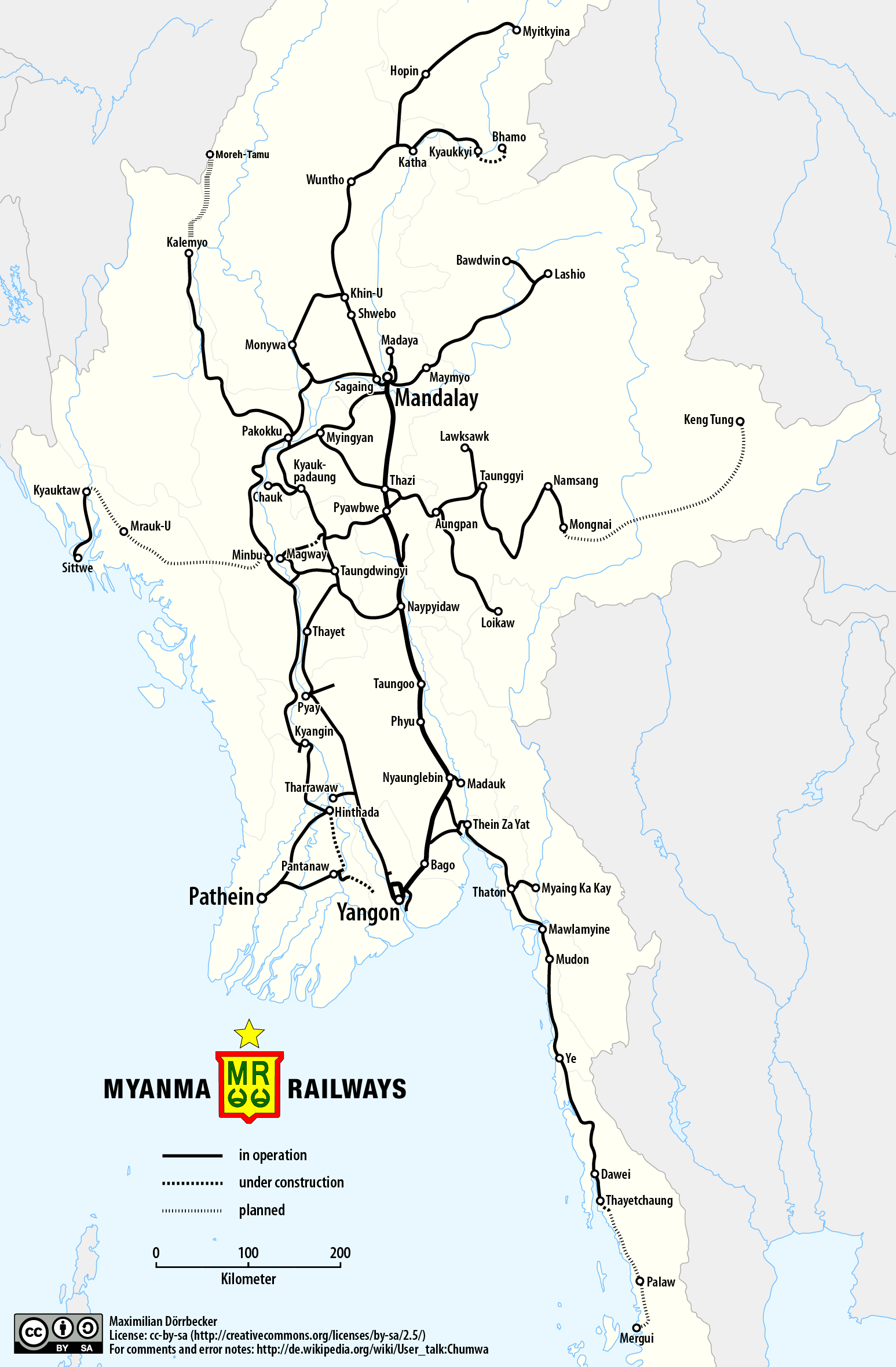
| ၀၅:၅၁၊ ၂၅ မေ ၂၀၁၇ |  | ၁၅၄၇ × ၂၃၆၀ (၅၂၅ KB) | Chumwa | {{Information |Description= *{{de|Eisenbahnkarte von Myanmar}} *{{en|Railway map of Myanmar}} |Source={{Own using}} *borders of Myanmar by {{U|Uwe Dedering}} *[http://www.myanmarailways1877.com/sites/default/files/Pla... |
ဖိုင်သုံးစွဲမှု
ဤဖိုင်ကို အသုံးပြုထားသော စာမျက်နှာများမရှိပါ။
ဂလိုဘယ် ဖိုင်သုံးစွဲမှု
အောက်ပါ အခြားဝီကီများတွင် ဤဖိုင်ကို အသုံးပြုထားသည်-
- de.wikipedia.org တွင် အသုံးပြုမှု
- en.wikipedia.org တွင် အသုံးပြုမှု
- ja.wikipedia.org တွင် အသုံးပြုမှု
- no.wikipedia.org တွင် အသုံးပြုမှု
- th.wikipedia.org တွင် အသုံးပြုမှု
- www.wikidata.org တွင် အသုံးပြုမှု
- zh.wikipedia.org တွင် အသုံးပြုမှု