
ဖိုင်:Radar-accumulations eng.png
ဤနမူနာ၏ အရွယ်အစား - ၇၆၉ × ၆၀၀ ပစ်ဇယ်။ အခြား ပုံရိပ်ပြတ်သားမှု: ၃၀၈ × ၂၄၀ ပစ်ဇယ် | ၆၁၆ × ၄၈၀ ပစ်ဇယ်။
မူရင်းဖိုင် (၈၀၀ × ၆၂၄ pixels, ဖိုင်အရွယ်အစား - ၁၅၉ KB, MIME အမျိုးအစား image/png)
| ဤဖိုင်သည် Wikimedia Commons မှဖြစ်ပြီး အခြားပရောဂျက်များတွင် သုံးကောင်းသုံးလိမ့်မည်။ ယင်း၏ ဖိုင်အကြောင်းစာမျက်နှာ တွင် ဖော်ပြထားချက်ကို အောက်တွင် ပြထားသည်။ Commons သည် မူပိုင်ခွင့်လွတ်လပ်သော မီဒီယာဖိုင်များ သိုလှောင်ထားရာ နေရာ ဖြစ်သည်။ သင်လည်း ပါဝင်ကူညီနိုင်ပါသည်။ |
အကျဉ်းချုပ်
| ဖော်ပြချက် |
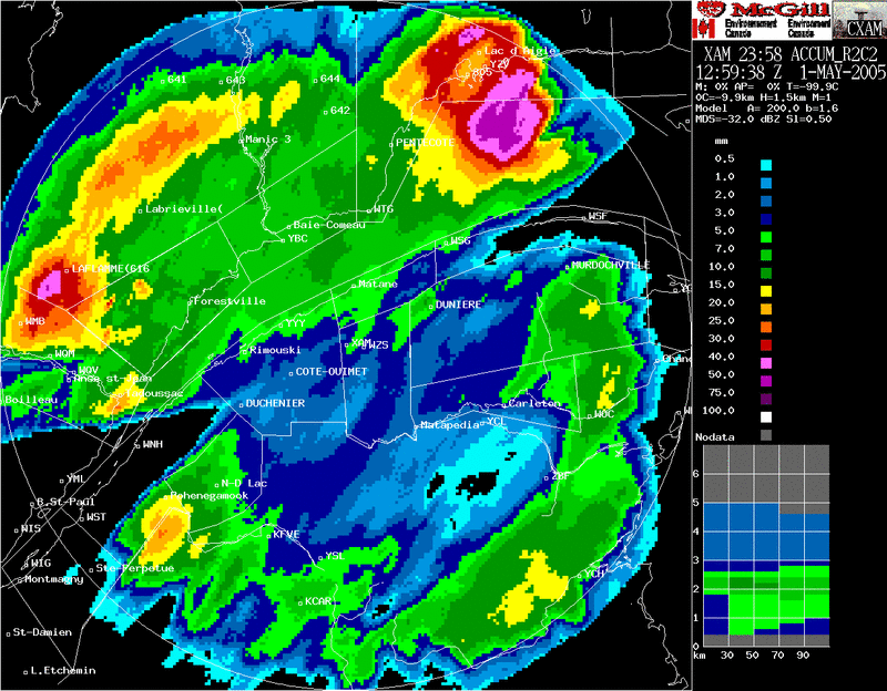
Français : Accumulations de 24 heures estimées à partir du radar de Val d'Irène dans l'est du Québec, Canada. Remarquez les cônes sans données vers l'est et le sud-ouest qui sont dus à des montagnes bloquant le faisceau radar. On voit également un zone plus intense en forme de beiget à la limite du radar qui est due à un rehaussement des retours par la bande brillante.
English: 24 hours accumulations deduced by Val d'Irene radar in Eastern Quebec (Canada). Some bright band effect visible with the stronger values at the outer right area. |
| ရက်စွဲ | 2005-05-01, 1259 UTC |
| ရင်းမြစ် |
English: Meteorological Service of Canada (Environment Canada). Redistribution allowed if source mentionned |
| စာရေးသူ |
Français : Ce radar est opéré par Environnement Canada. La sortie radar est produite par le logiciel développé par l'Observatoire radar J.S. Marshall de l'Université McGill en collaboration avec EC. |
လိုင်စင်သတ်မှတ်ခြင်း

|
The copyright holder of this work allows anyone to use it for any purpose including unrestricted redistribution, commercial use, and modification.
Usage notes:
|
ဖိုင်မှတ်တမ်း
ဖိုင်ကို ယင်းနေ့စွဲ အတိုင်း မြင်နိုင်ရန် နေ့စွဲ/အချိန် တစ်ခုခုပေါ်တွင် ကလစ်နှိပ်ပါ။
| နေ့စွဲ/အချိန် | နမူနာပုံငယ် | မှတ်တမ်း ဒိုင်မန်းရှင်းများ | အသုံးပြုသူ | မှတ်ချက် | |
|---|---|---|---|---|---|
| ကာလပေါ် | ၁၄:၄၉၊ ၈ မေ ၂၀၀၆ | | ၈၀၀ × ၆၂၄ (၁၅၉ KB) | Pierre cb | 24 hours accumulations deduced by Val d'Irene radar in Eastern Quebec (Canada). Some bright band effect visible with the stronger vlaues at the outer right area. Source: Meteorological Service of Canada (Environment Canada). Redistribution allowed if sou |
ဖိုင်သုံးစွဲမှု
ဤဖိုင်ကို အသုံးပြုထားသော စာမျက်နှာများမရှိပါ။
ဂလိုဘယ် ဖိုင်သုံးစွဲမှု
အောက်ပါ အခြားဝီကီများတွင် ဤဖိုင်ကို အသုံးပြုထားသည်-
- en.wikipedia.org တွင် အသုံးပြုမှု
- es.wikipedia.org တွင် အသုံးပြုမှု
- fr.wikipedia.org တွင် အသုံးပြုမှု
- id.wikipedia.org တွင် အသုံးပြုမှု
- ms.wikipedia.org တွင် အသုံးပြုမှု
- pt.wikipedia.org တွင် အသုံးပြုမှု