
ဖိုင်:Qing Empire circa 1820 EN.svg

Size of this PNG preview of this SVG file: ၆၈၆ × ၆၀၀ ပစ်ဇယ်. အခြား ပုံရိပ်ပြတ်သားမှု: ၂၇၅ × ၂၄၀ ပစ်ဇယ် | ၅၄၉ × ၄၈၀ ပစ်ဇယ် | ၈၇၉ × ၇၆၈ ပစ်ဇယ် | ၁၁၇၂ × ၁၀၂၄ ပစ်ဇယ် | ၂၃၄၃ × ၂၀၄၈ ပစ်ဇယ် | ၈၄၉ × ၇၄၂ ပစ်ဇယ်။
မူရင်းဖိုင် (SVG ဖိုင်, ၈၄၉ × ၇၄၂ pixels ကို အကြံပြုသည်, ဖိုင်အရွယ်အစား - ၅၄၈ KB)
| ဤဖိုင်သည် Wikimedia Commons မှဖြစ်ပြီး အခြားပရောဂျက်များတွင် သုံးကောင်းသုံးလိမ့်မည်။ ယင်း၏ ဖိုင်အကြောင်းစာမျက်နှာ တွင် ဖော်ပြထားချက်ကို အောက်တွင် ပြထားသည်။ Commons သည် မူပိုင်ခွင့်လွတ်လပ်သော မီဒီယာဖိုင်များ သိုလှောင်ထားရာ နေရာ ဖြစ်သည်။ သင်လည်း ပါဝင်ကူညီနိုင်ပါသည်။ |
အကျဉ်းချုပ်
| ဖော်ပြချက် |
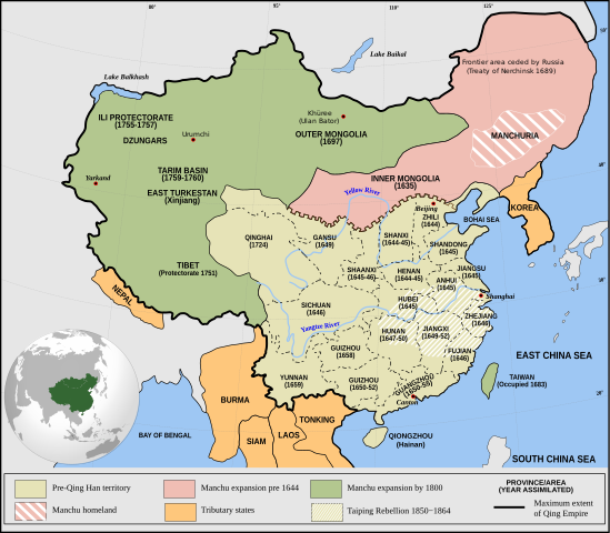
English: Qing Empire c. 1820 |
| ရက်စွဲ | |
| ရင်းမြစ် | ကိုယ်ပိုင်ဖန်တီးမှု Incorporates modified version of File:Empire of the Great Qing (orthographic projection).svg. Note that the map excludes Tawang from Tibet. |
| စာရေးသူ | Philg88: Attribution Wikimedia Foundation, www.wikimedia.org |
.svg)
လိုင်စင်သတ်မှတ်ခြင်း
ဤဖိုင်သည် Creative Commons Attribution 4.0 နိုင်ငံတကာ လိုင်စင်အောက်တွင် လိုင်စင်သတ်မှတ်ထားပါသည်။
- သင်သည် လွတ်လပ်စွာ:
- မျှဝေရန် – ဖန်တီးမှုကို ကူးယူရန်၊ ဖြန့်ဖြူးရန်နှင့် ထုတ်လွှင့်ရန်
- ပြန်ရောနှောရန် – ဖန်တီးမှုကို ပြင်ဆင်ညှိနှိုင်းရန်
- အောက်ပါ အခြေအနေများတွင်:
- မှတ်ယူနိုင်ခြင်း – ပြောင်းလဲမှုများ ပြုလုပ်ခဲ့ပါက ဖန်တီးသူ သို့မဟုတ် လိုင်စင်ရှိသူမှ သတ်မှတ်သော အမျိုးအစားကို လိုက်နာရမည် (ဆိုလိုသည်မှာ သင့်အား သို့မဟုတ် သင့်ဖန်တီးမှုတွင် အသုံးပြုခြင်းအား ထောက်ခံချက်ပေးသည်ဟု မဆိုလိုပါ)။
ဖိုင်မှတ်တမ်း
ဖိုင်ကို ယင်းနေ့စွဲ အတိုင်း မြင်နိုင်ရန် နေ့စွဲ/အချိန် တစ်ခုခုပေါ်တွင် ကလစ်နှိပ်ပါ။
| နေ့စွဲ/အချိန် | နမူနာပုံငယ် | မှတ်တမ်း ဒိုင်မန်းရှင်းများ | အသုံးပြုသူ | မှတ်ချက် | |
|---|---|---|---|---|---|
| ကာလပေါ် | ၂၀:၀၃၊ ၁၃ ဇွန် ၂၀၂၁ | | ၈၄၉ × ၇၄၂ (၅၄၈ KB) | SSH remoteserver | Reverted to version as of 03:34, 13 June 2021 (UTC) |
| ၁၈:၃၁၊ ၁၃ ဇွန် ၂၀၂၁ |  | ၈၄၉ × ၇၄၂ (၅၄၈ KB) | SSH remoteserver | Reverted to version as of 00:04, 13 June 2021 (UTC) | |
| ၀၃:၃၄၊ ၁၃ ဇွန် ၂၀၂၁ |  | ၈၄၉ × ၇၄၂ (၅၄၈ KB) | NorthTension | Reverted to version as of 07:44, 15 December 2020 (UTC) | |
| ၀၀:၀၄၊ ၁၃ ဇွန် ၂၀၂၁ |  | ၈၄၉ × ၇၄၂ (၅၄၈ KB) | SSH remoteserver | Burma was not a tributary. Please See: A Disguised Defeat https://www.jstor.org/stable/3876499; and Burmese Chronicles | |
| ၀၇:၄၄၊ ၁၅ ဒီဇင်ဘာ ၂၀၂၀ |  | ၈၄၉ × ၇၄၂ (၅၄၈ KB) | LiliCharlie | Reverted to version as of 21:26, 10 October 2020 (UTC) — that's an embedded bitmap rather than a vector image — as Bidgee said, if you dispute it, upload under a new file name, perhaps as a PNG file | |
| ၀၇:၁၃၊ ၁၅ ဒီဇင်ဘာ ၂၀၂၀ |  | ၁၁၇၂ × ၁၀၂၄ (၅၀၉ KB) | Бмхүн | Reverted to version as of 10:04, 24 March 2020 (UTC) | |
| ၂၁:၂၆၊ ၁၀ အောက်တိုဘာ ၂၀၂၀ |  | ၈၄၉ × ၇၄၂ (၅၄၈ KB) | Bidgee | Reverted to version as of 16:15, 29 April 2014 (UTC) if you dispute it, upload under a new file per COM:OVERWRITE | |
| ၁၁:၀၀၊ ၄ အောက်တိုဘာ ၂၀၂၀ |  | ၁၁၇၂ × ၁၀၂၄ (၅၀၉ KB) | Бмхүн | The oldest version has too much wrong,such as Guizhou should be Guangxi, Caton isn’t Guangdong, and manchus homeland located in south part of Manchuria | |
| ၁၆:၅၄၊ ၂၃ ဇွန် ၂၀၂၀ |  | ၈၄၉ × ၇၄၂ (၅၄၈ KB) | LiliCharlie | Reverted embedded bitmap version to true vector version as of 16:15, 29 April 2014 (UTC) | |
| ၁၀:၀၄၊ ၂၄ မတ် ၂၀၂၀ |  | ၁၁၇၂ × ၁၀၂၄ (၅၀၉ KB) | Anchuhu | Reverted to version as of 06:35, 9 January 2019 (UTC) the borders and provinces name are wrong |
ဖိုင်သုံးစွဲမှု
ဤဖိုင်ကို အသုံးပြုထားသော စာမျက်နှာများမရှိပါ။
ဂလိုဘယ် ဖိုင်သုံးစွဲမှု
အောက်ပါ အခြားဝီကီများတွင် ဤဖိုင်ကို အသုံးပြုထားသည်-
- ar.wikipedia.org တွင် အသုံးပြုမှု
- cdo.wikipedia.org တွင် အသုံးပြုမှု
- cs.wikipedia.org တွင် အသုံးပြုမှု
- da.wikipedia.org တွင် အသုံးပြုမှု
- de.wikipedia.org တွင် အသုံးပြုမှု
- el.wikipedia.org တွင် အသုံးပြုမှု
- en.wikipedia.org တွင် အသုံးပြုမှု
- China
- History of China
- History of Asia
- Imperialism
- History of East Asia
- Taiping Rebellion
- Manchu people
- History of Tibet
- Treaty of Nerchinsk
- Portal:China
- Portal:Asia
- History of Mongolia
- Amur Annexation
- Transition from Ming to Qing
- Settler colonialism
- Talk:Qing dynasty/Archive 5
- Tibet under Qing rule
- Xinjiang under Qing rule
- List of modern great powers
- Timeline of the Qing dynasty
- Talk:COVID-19 pandemic/Archive 2
- User talk:FuzionEXA
- User:Sanskar shingare/sandbox
- User:Falcaorib/China
- es.wikipedia.org တွင် အသုံးပြုမှု
- et.wikipedia.org တွင် အသုံးပြုမှု
- fa.wikipedia.org တွင် အသုံးပြုမှု
- fr.wikipedia.org တွင် အသုံးပြုမှု
ဤဖိုင်ကို အခြားနေရာများတွင် အသုံးပြုထားမှုများအား ကြည့်ရှုရန်။