ဖိုင်:Pakistan relief location map.jpg
အခြားဘာသာစကားများဖြင့် စာမျက်နှာအကြောင်းအရာများကို ပံ့ပိုးမထားပါ။
This is a file from the Wikimedia Commons
ဝီကီပီးဒီးယား မှ

မူရင်းဖိုင်(၂၃၆၅ × ၁၈၉၀ pixels, ဖိုင်အရွယ်အစား - ၁.၉၃ MB, MIME အမျိုးအစား image/jpeg)

ဖော်ပြချက်
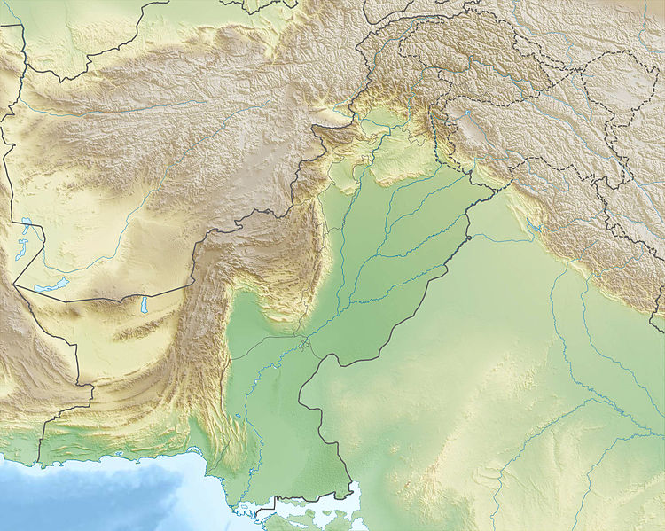
Deutsch: Physische Positionskarte von Pakistan

Quadratische Plattkarte, N-S-Streckung 115 %. Geographische Begrenzung der Karte:

  • N: 37.3° N
  • S: 23.4° N
  • W: 60.5° O
  • O: 80.5° O
English: Physical location map of Pakistan

Equirectangular projection, N/S stretching 115 %. Geographic limits of the map:

  • N: 37.3° N
  • S: 23.4° N
  • W: 60.5° E
  • E: 80.5° E
ရက်စွဲ
ရင်းမြစ်

ကိုယ်ပိုင်ဖန်တီးမှု, using

စာရေးသူ Carport
ခွင့်ပြုချက်
(ဤဖိုင်ကို ပြန်လည်အသုံးပြုခြင်း)
w:my:Creative Commons
မှတ်ယူနိုင်ခြင်း ထပ်တူမျှဝေ
ဤဖိုင်ကို Creative Commons Attribution-Share Alike 3.0 Unported လိုင်စင်ဖြင့် သတ်မှတ်ထားသည်။
သင်သည် လွတ်လပ်စွာ:
  • မျှဝေရန် – ဖန်တီးမှုကို ကူးယူရန်၊ ဖြန့်ဖြူးရန်နှင့် ထုတ်လွှင့်ရန်
  • ပြန်ရောနှောရန် – ဖန်တီးမှုကို ပြင်ဆင်ညှိနှိုင်းရန်
အောက်ပါ အခြေအနေများတွင်:
  • မှတ်ယူနိုင်ခြင်း – ပြောင်းလဲမှုများ ပြုလုပ်ခဲ့ပါက ဖန်တီးသူ သို့မဟုတ် လိုင်စင်ရှိသူမှ သတ်မှတ်သော အမျိုးအစားကို လိုက်နာရမည် (ဆိုလိုသည်မှာ သင့်အား သို့မဟုတ် သင့်ဖန်တီးမှုတွင် အသုံးပြုခြင်းအား ထောက်ခံချက်ပေးသည်ဟု မဆိုလိုပါ)။
  • ထပ်တူမျှဝေ – ဤဖန်တီးမှုအား ပြင်ဆင်ခြင်း၊ ပြောင်းလဲခြင်း သို့မဟုတ် ထပ်ဆင့် ဖန်တီးခြင်း ပြုလုပ်ပါက ရရှိလာသော ဖန်တီးမှုကို ဤဖန်တီးမှုနှင့် သို့မဟုတ် ဆင်တူသော လိုင်စင်ဖြင့်သာ ဖြန့်ချိသင့်သည်။
အခြား ဗားရှင်းများ

ပုံစာများ

ဤဖိုင်၏ဆိုလိုရင်းကို စာတစ်ကြောင်းရှင်းလင်းချက်ဖြင့် ထည့်သွင်းရန်
Pakistan relief location map

Items portrayed in this file

depicts အင်္ဂလိပ်

some value

object has role အင်္ဂလိပ်: photographer အင်္ဂလိပ်
author name string အင်္ဂလိပ်: Carport
Wikimedia username အင်္ဂလိပ်: Carport

ဖိုင်မှတ်တမ်း

ဖိုင်ကို ယင်းနေ့စွဲ အတိုင်း မြင်နိုင်ရန် နေ့စွဲ/အချိန် တစ်ခုခုပေါ်တွင် ကလစ်နှိပ်ပါ။

နေ့စွဲ/အချိန်နမူနာပုံငယ်မှတ်တမ်း ဒိုင်မန်းရှင်းများအသုံးပြုသူမှတ်ချက်
ကာလပေါ် ၂၂:၄၄၊ ၁၄ ဒီဇင်ဘာ ၂၀၁၂ ၂၂:၄၄၊ ၁၄ ဒီဇင်ဘာ ၂၀၁၂ ရက်က မူအတွက် နမူနာပုံငယ်၂၃၆၅ × ၁၈၉၀ (၁.၉၃ MB)Carport{{Information |Description= {{de|Physische Positionskarte von Pakistan}} Quadratische Plattkarte, N-S-Streckung 115 %. Geographische Begrenzung der Karte: * N: 37.3° N * S: 23.4° N * W: 60.5° O * O: 80.5° O {{en|Physical location m...

ဂလိုဘယ် ဖိုင်သုံးစွဲမှု

အောက်ပါ အခြားဝီကီများတွင် ဤဖိုင်ကို အသုံးပြုထားသည်-

ဤဖိုင်ကို အခြားနေရာများတွင် အသုံးပြုထားမှုများအား ကြည့်ရှုရန်။