
ဖိုင်:Pahalgam Valley.jpg
ဤနမူနာ၏ အရွယ်အစား - ၈၀၀ × ၄၄၆ ပစ်ဇယ်။ အခြား ပုံရိပ်ပြတ်သားမှု: ၃၂၀ × ၁၇၈ ပစ်ဇယ် | ၆၄၀ × ၃၅၇ ပစ်ဇယ် | ၁၀၂၄ × ၅၇၁ ပစ်ဇယ် | ၁၂၈၀ × ၇၁၄ ပစ်ဇယ် | ၂၅၆၀ × ၁၄၂၈ ပစ်ဇယ် | ၆၇၄၅ × ၃၇၆၂ ပစ်ဇယ်။
မူရင်းဖိုင် (၆၇၄၅ × ၃၇၆၂ pixels, ဖိုင်အရွယ်အစား - ၁၄.၃၇ MB, MIME အမျိုးအစား image/jpeg)
| ဤဖိုင်သည် Wikimedia Commons မှဖြစ်ပြီး အခြားပရောဂျက်များတွင် သုံးကောင်းသုံးလိမ့်မည်။ ယင်း၏ ဖိုင်အကြောင်းစာမျက်နှာ တွင် ဖော်ပြထားချက်ကို အောက်တွင် ပြထားသည်။ Commons သည် မူပိုင်ခွင့်လွတ်လပ်သော မီဒီယာဖိုင်များ သိုလှောင်ထားရာ နေရာ ဖြစ်သည်။ သင်လည်း ပါဝင်ကူညီနိုင်ပါသည်။ |
အကျဉ်းချုပ်
| ဖော်ပြချက် |
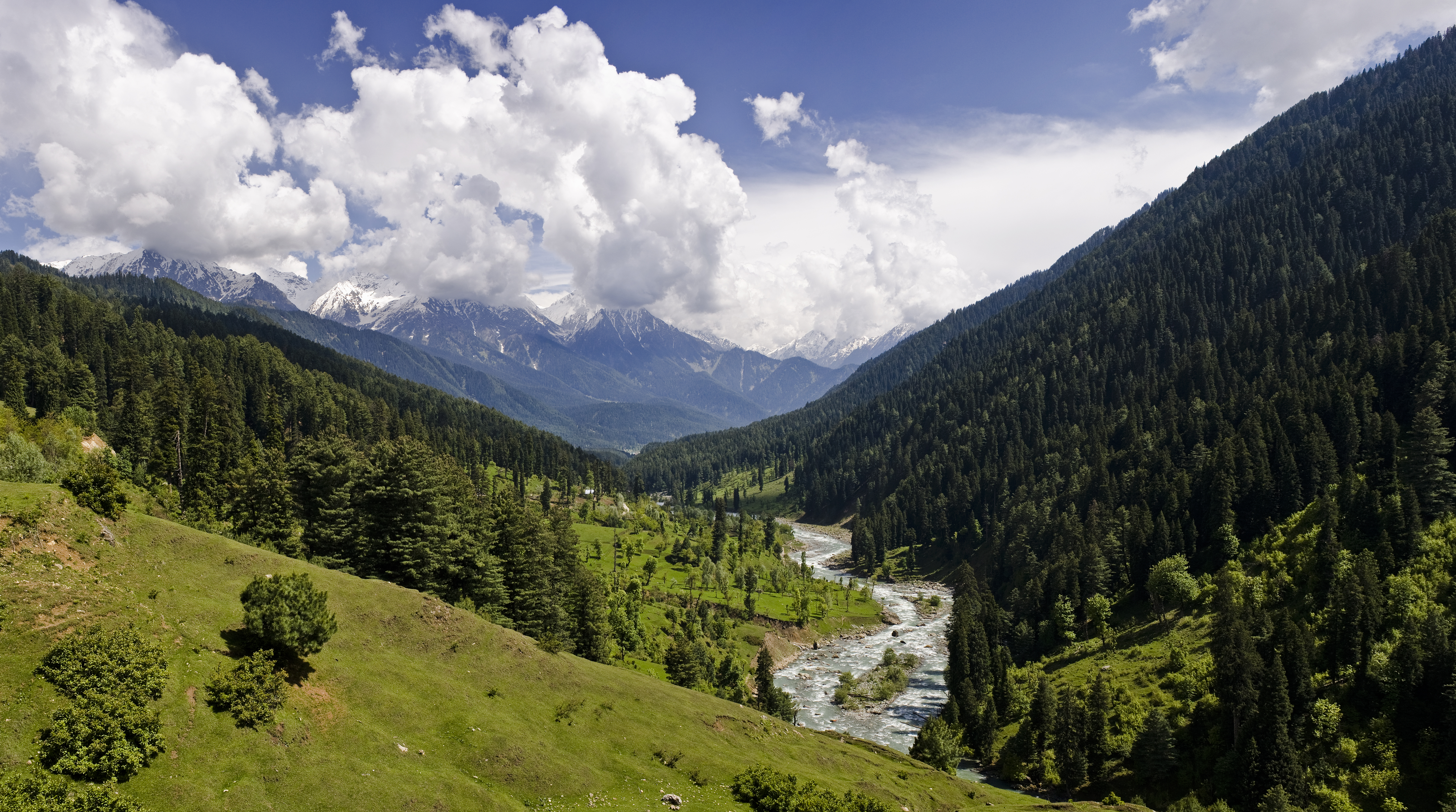
English: View of the Pahalgam Valley
Español: Vista del valle de Lidder cerca de Pahalgam. Este valle del Himalaya se encuentra en la parte noreste del valle de Cachemira en Jammu y Cachemira, India.
Українська: Долина Ліддер — гімалайська долина поблизу міста Пахалгама в північно-східній частині Кашмірської долини у штаті Джамму і Кашмір, Індія. |
| ရက်စွဲ | Taken on ၄ ဇွန် ၂၀၁၁ |
| ရင်းမြစ် | ကိုယ်ပိုင်ဖန်တီးမှု |
| စာရေးသူ | KennyOMG |
| Camera location | | View this and other nearby images on: OpenStreetMap |
|---|
The geographical information in this file was retrospectively estimated.
The location may therefore be somewhat imprecise. Verifying and refining these coordinates is strongly encouraged. |
Assessment
|
This image was selected as picture of the day on Wikimedia Commons for 21 July 2023. It was captioned as follows: English: The Lidder Valley near Pahalgam. This Himalayan valley lies in the northeastern part of the Vale of Kashmir in Jammu and Kashmir, India. Other languages:
Čeština: Himálajské údolí "Lidder Valley" nedaleko osady Pahalgamu leží v severovýchodní oblasti Kašmírského údolí v indické správní oblasti Džammú a Kašmír. English: The Lidder Valley near Pahalgam. This Himalayan valley lies in the northeastern part of the Vale of Kashmir in Jammu and Kashmir, India. Español: Vista del valle de Lidder cerca de Pahalgam. Este valle del Himalaya se encuentra en la parte noreste del valle de Cachemira en Jammu y Cachemira, India. Français : La vallée himalayenne de Lidder, située au nord-est de la vallée du Cachemire dans le territoire de Jammu-et-Cachemire (Inde) Italiano: La Lidder Valley vicino a Pahalgam. Questa valle himalayana si trova nella parte nord-orientale della valle del Kashmir nel territorio di Jammu e Kashmir, India. Magyar: A Lidder-völgy látképe Pahalgam közelében. Ez a himalájai völgy a Kasmír-völgy északkeleti részén fekszik (Dzsammu és Kasmír, India) Português: Vista do Vale Lidder perto de Pahalgam. Este vale do Himalaia fica na parte nordeste do vale de Caxemira em Jammu e Caxemira, na Índia. Slovenščina: Dolina Lider blizu Pahalgama. Ta himalajska dolina leži v severovzhodnem delu Kašmirja na območju indjskega zveznega ozemlja Džamu in Kašmir. Українська: Долина Ліддер — гімалайська долина поблизу міста Пахалгама в північно-східній частині Кашмірської долини у штаті Джамму і Кашмір, Індія. |
This image was selected as picture of the day on Bengali Wikipedia.
|
လိုင်စင်သတ်မှတ်ခြင်း
ကျွန်ုပ်၊ ဤလုပ်ဆောင်ချက်၏ မူပိုင်ခွင့်ပိုင်ရှင်အနေဖြင့် ဤနေရာမှ အောက်ပါလိုင်စင်အောက်တွင် ထုတ်လွှင့်ပါသည်:
ဤဖိုင်ကို Creative Commons Attribution-Share Alike 3.0 Unported လိုင်စင်ဖြင့် သတ်မှတ်ထားသည်။
- သင်သည် လွတ်လပ်စွာ:
- မျှဝေရန် – ဖန်တီးမှုကို ကူးယူရန်၊ ဖြန့်ဖြူးရန်နှင့် ထုတ်လွှင့်ရန်
- ပြန်ရောနှောရန် – ဖန်တီးမှုကို ပြင်ဆင်ညှိနှိုင်းရန်
- အောက်ပါ အခြေအနေများတွင်:
- မှတ်ယူနိုင်ခြင်း – ပြောင်းလဲမှုများ ပြုလုပ်ခဲ့ပါက ဖန်တီးသူ သို့မဟုတ် လိုင်စင်ရှိသူမှ သတ်မှတ်သော အမျိုးအစားကို လိုက်နာရမည် (ဆိုလိုသည်မှာ သင့်အား သို့မဟုတ် သင့်ဖန်တီးမှုတွင် အသုံးပြုခြင်းအား ထောက်ခံချက်ပေးသည်ဟု မဆိုလိုပါ)။
- ထပ်တူမျှဝေ – ဤဖန်တီးမှုအား ပြင်ဆင်ခြင်း၊ ပြောင်းလဲခြင်း သို့မဟုတ် ထပ်ဆင့် ဖန်တီးခြင်း ပြုလုပ်ပါက ရရှိလာသော ဖန်တီးမှုကို ဤဖန်တီးမှုနှင့် သို့မဟုတ် ဆင်တူသော လိုင်စင်ဖြင့်သာ ဖြန့်ချိသင့်သည်။
ဖိုင်မှတ်တမ်း
ဖိုင်ကို ယင်းနေ့စွဲ အတိုင်း မြင်နိုင်ရန် နေ့စွဲ/အချိန် တစ်ခုခုပေါ်တွင် ကလစ်နှိပ်ပါ။
| နေ့စွဲ/အချိန် | နမူနာပုံငယ် | မှတ်တမ်း ဒိုင်မန်းရှင်းများ | အသုံးပြုသူ | မှတ်ချက် | |
|---|---|---|---|---|---|
| ကာလပေါ် | ၀၆:၀၀၊ ၂၁ နိုဝင်ဘာ ၂၀၁၅ | | ၆၇၄၅ × ၃၇၆၂ (၁၄.၃၇ MB) | KennyOMG | size? |
| ၁၆:၁၅၊ ၅ ဇွန် ၂၀၁၁ |  | ၄၀၀၀ × ၂၀၈၇ (၃.၃၆ MB) | KennyOMG |
ဖိုင်သုံးစွဲမှု
ဤဖိုင်ကို အသုံးပြုထားသော စာမျက်နှာများမရှိပါ။
ဂလိုဘယ် ဖိုင်သုံးစွဲမှု
အောက်ပါ အခြားဝီကီများတွင် ဤဖိုင်ကို အသုံးပြုထားသည်-
- alt.wikipedia.org တွင် အသုံးပြုမှု
- ang.wikipedia.org တွင် အသုံးပြုမှု
- ar.wikipedia.org တွင် အသုံးပြုမှု
- arz.wikipedia.org တွင် အသုံးပြုမှု
- av.wikipedia.org တွင် အသုံးပြုမှု
- ba.wikipedia.org တွင် အသုံးပြုမှု
- bh.wikipedia.org တွင် အသုံးပြုမှု
- bn.wikipedia.org တွင် အသုံးပြုမှု
- উইকিপিডিয়া:আজকের নির্বাচিত ছবি/আগস্ট ২০১৬
- ব্যবহারকারী:চন্দ্রশেখর/খেলাঘর/কাশ্মীর
- টেমপ্লেট:আজকের নির্বাচিত ছবি/১২ আগস্ট ২০১৬
- কাশ্মীর উপত্যকা
- ব্যবহারকারী আলাপ:Meghmollar2017
- পহেলগাম
- জম্মু ও কাশ্মীর (কেন্দ্রশাসিত অঞ্চল)
- অনন্তনাগ জেলা
- ভারতের শৈলশহরের তালিকা
- উইকিপিডিয়া:আজকের নির্বাচিত ছবি/জুলাই ২০২৩
- টেমপ্লেট:আজকের নির্বাচিত ছবি/২১ জুলাই ২০২৩
- ব্যবহারকারী আলাপ:Yahya/সংগ্রহশালা ২৫
- br.wikipedia.org တွင် အသုံးပြုမှု
- ca.wikipedia.org တွင် အသုံးပြုမှု
- ceb.wikipedia.org တွင် အသုံးပြုမှု
- ckb.wikipedia.org တွင် အသုံးပြုမှု
- cv.wikipedia.org တွင် အသုံးပြုမှု
- de.wikipedia.org တွင် အသုံးပြုမှု
- diq.wikipedia.org တွင် အသုံးပြုမှု
- en.wikipedia.org တွင် အသုံးပြုမှု
ဤဖိုင်ကို အခြားနေရာများတွင် အသုံးပြုထားမှုများအား ကြည့်ရှုရန်။