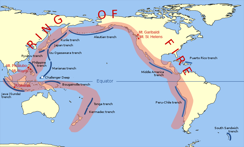
ဖိုင်:Pacific Ring of Fire.svg

Size of this PNG preview of this SVG file: ၈၀၀ × ၄၈၃ ပစ်ဇယ်. အခြား ပုံရိပ်ပြတ်သားမှု: ၃၂၀ × ၁၉၃ ပစ်ဇယ် | ၆၄၀ × ၃၈၇ ပစ်ဇယ် | ၁၀၂၄ × ၆၁၉ ပစ်ဇယ် | ၁၂၈၀ × ၇၇၃ ပစ်ဇယ် | ၂၅၆၀ × ၁၅၄၆ ပစ်ဇယ် | ၉၄၂ × ၅၆၉ ပစ်ဇယ်။
မူရင်းဖိုင် (SVG ဖိုင်, ၉၄၂ × ၅၆၉ pixels ကို အကြံပြုသည်, ဖိုင်အရွယ်အစား - ၂၉၄ KB)
ဖိုင်မှတ်တမ်း
ဖိုင်ကို ယင်းနေ့စွဲ အတိုင်း မြင်နိုင်ရန် နေ့စွဲ/အချိန် တစ်ခုခုပေါ်တွင် ကလစ်နှိပ်ပါ။
| နေ့စွဲ/အချိန် | နမူနာပုံငယ် | မှတ်တမ်း ဒိုင်မန်းရှင်းများ | အသုံးပြုသူ | မှတ်ချက် | |
|---|---|---|---|---|---|
| ကာလပေါ် | ၁၁:၃၀၊ ၂၀ မတ် ၂၀၁၅ |  | ၉၄၂ × ၅၆၉ (၂၉၄ KB) | Szczureq | Ryuku → Ryukyu |
| ၁၃:၁၉၊ ၁၅ မတ် ၂၀၁၁ |  | ၉၄၂ × ၅၆၉ (၂၉၄ KB) | AnonMoos | trimming transparent margins | |
| ၁၉:၂၅၊ ၃ မတ် ၂၀၀၉ |  | ၇၉၆ × ၄၇၂ (၃၁၄ KB) | Kmusser | Fix volanco symbols | |
| ၁၉:၀၄၊ ၃ မတ် ၂၀၀၉ |  | ၇၉၆ × ၄၇၂ (၃၁၇ KB) | Kmusser | repositioned volcanoes | |
| ၂၃:၂၄၊ ၁၃ ဖေဖော်ဝါရီ ၂၀၀၉ |  | ၇၈၁ × ၄၇၂ (၁၄၅ KB) | Inductiveload | added volcanos | |
| ၁၇:၁၈၊ ၁၁ ဖေဖော်ဝါရီ ၂၀၀၉ |  | ၇၈၁ × ၄၇၂ (၁၃၈ KB) | Inductiveload | added labels, aluetian isles and south sandwich islands, as these are associated with the nearby trenches. also put everything into layers. | |
| ၂၃:၅၈၊ ၁၀ ဖေဖော်ဝါရီ ၂၀၀၉ |  | ၇၈၁ × ၄၇၂ (၁၁၁ KB) | Gringer | Resized image 3x so that nominal size is reasonable in default Wikipedia image display. | |
| ၂၃:၅၂၊ ၁၀ ဖေဖော်ဝါရီ ၂၀၀၉ |  | ၂၆၀ × ၁၅၇ (၁၁၂ KB) | Gringer | {{Information |Description={{en|1=SVG version of File:Pacific_Ring_of_Fire.png, recreated by me using WDB vector data using code mentioned in File:Worldmap_wdb_combined.svg.}} |Source=vector data from [http://www.evl.uic.edu/pape/data/WDB/] |Aut |
ဖိုင်သုံးစွဲမှု
ဤဖိုင်ကို အသုံးပြုထားသော စာမျက်နှာများမရှိပါ။
ဂလိုဘယ် ဖိုင်သုံးစွဲမှု
အောက်ပါ အခြားဝီကီများတွင် ဤဖိုင်ကို အသုံးပြုထားသည်-
- af.wikipedia.org တွင် အသုံးပြုမှု
- ar.wikipedia.org တွင် အသုံးပြုမှု
- ast.wikipedia.org တွင် အသုံးပြုမှု
- ban.wikipedia.org တွင် အသုံးပြုမှု
- bcl.wikipedia.org တွင် အသုံးပြုမှု
- bg.wikipedia.org တွင် အသုံးပြုမှု
- bn.wikipedia.org တွင် အသုံးပြုမှု
- bs.wikipedia.org တွင် အသုံးပြုမှု
- da.wikipedia.org တွင် အသုံးပြုမှု
- el.wikipedia.org တွင် အသုံးပြုမှု
- en.wikipedia.org တွင် အသုံးပြုမှု
- en.wikibooks.org တွင် အသုံးပြုမှု
- en.wikivoyage.org တွင် အသုံးပြုမှု
- en.wiktionary.org တွင် အသုံးပြုမှု
- es.wikipedia.org တွင် အသုံးပြုမှု
- fa.wikipedia.org တွင် အသုံးပြုမှု
- fi.wikipedia.org တွင် အသုံးပြုမှု
- he.wikipedia.org တွင် အသုံးပြုမှု
- hi.wikipedia.org တွင် အသုံးပြုမှု
- hu.wikipedia.org တွင် အသုံးပြုမှု
- ilo.wikipedia.org တွင် အသုံးပြုမှု
- incubator.wikimedia.org တွင် အသုံးပြုမှု
- is.wikipedia.org တွင် အသုံးပြုမှု
- is.wikibooks.org တွင် အသုံးပြုမှု
- it.wikibooks.org တွင် အသုံးပြုမှု
- ja.wikipedia.org တွင် အသုံးပြုမှု
- ja.wikibooks.org တွင် အသုံးပြုမှု
- jv.wikipedia.org တွင် အသုံးပြုမှု
- ka.wikipedia.org တွင် အသုံးပြုမှု
- kk.wikipedia.org တွင် အသုံးပြုမှု
- la.wikipedia.org တွင် အသုံးပြုမှု
ဤဖိုင်ကို အခြားနေရာများတွင် အသုံးပြုထားမှုများအား ကြည့်ရှုရန်။


