
ဖိုင်:NOAA chart 25664 1976 detail.png
ဤနမူနာ၏ အရွယ်အစား - ၇၁၆ × ၆၀၀ ပစ်ဇယ်။ အခြား ပုံရိပ်ပြတ်သားမှု: ၂၈၇ × ၂၄၀ ပစ်ဇယ် | ၅၇၃ × ၄၈၀ ပစ်ဇယ် | ၉၀၆ × ၇၅၉ ပစ်ဇယ်။
မူရင်းဖိုင် (၉၀၆ × ၇၅၉ pixels, ဖိုင်အရွယ်အစား - ၁.၁၉ MB, MIME အမျိုးအစား image/png)
| ဤဖိုင်သည် Wikimedia Commons မှဖြစ်ပြီး အခြားပရောဂျက်များတွင် သုံးကောင်းသုံးလိမ့်မည်။ ယင်း၏ ဖိုင်အကြောင်းစာမျက်နှာ တွင် ဖော်ပြထားချက်ကို အောက်တွင် ပြထားသည်။ Commons သည် မူပိုင်ခွင့်လွတ်လပ်သော မီဒီယာဖိုင်များ သိုလှောင်ထားရာ နေရာ ဖြစ်သည်။ သင်လည်း ပါဝင်ကူညီနိုင်ပါသည်။ |
အကျဉ်းချုပ်
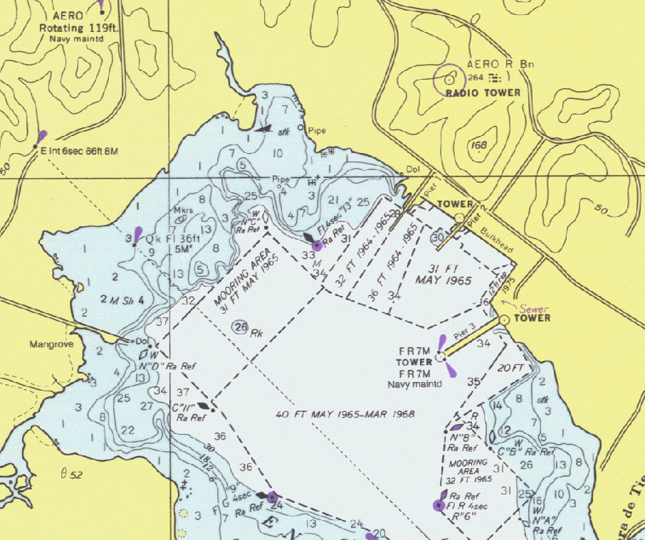
Detail of United States National Oceanic and Atmospheric Administration (NOAA) chart 25664 - Pasaje de Vieques and Radas Roosevelt, Puerto Rico.
This is from an outdated 1976 version of this chart; scanned by NOAA and provided through NOAA's Office of Coast Survey Historical Map and Chart Collection. Converted and clipped by the uploader.
လိုင်စင်သတ်မှတ်ခြင်း
This image is in the public domain because it contains materials that originally came from the U.S. National Oceanic and Atmospheric Administration, taken or made as part of an employee's official duties.
|
ဖိုင်မှတ်တမ်း
ဖိုင်ကို ယင်းနေ့စွဲ အတိုင်း မြင်နိုင်ရန် နေ့စွဲ/အချိန် တစ်ခုခုပေါ်တွင် ကလစ်နှိပ်ပါ။
| နေ့စွဲ/အချိန် | နမူနာပုံငယ် | မှတ်တမ်း ဒိုင်မန်းရှင်းများ | အသုံးပြုသူ | မှတ်ချက် | |
|---|---|---|---|---|---|
| ကာလပေါ် | ၂၃:၂၇၊ ၁ ဇန်နဝါရီ ၂၀၀၆ | | ၉၀၆ × ၇၅၉ (၁.၁၉ MB) | Cdc~commonswiki | Detail of United States National Oceanic and Atmospheric Administration (NOAA) chart 25664 - Pasaje de Vieques and Radas Roosevelt, Puerto Rico. This is from an outdated 1976 version of this chart; scanned by NOAA and provided through NOAA's Office of C |
ဖိုင်သုံးစွဲမှု
ဤဖိုင်ကို အသုံးပြုထားသော စာမျက်နှာများမရှိပါ။
ဂလိုဘယ် ဖိုင်သုံးစွဲမှု
အောက်ပါ အခြားဝီကီများတွင် ဤဖိုင်ကို အသုံးပြုထားသည်-
- en.wikipedia.org တွင် အသုံးပြုမှု
- es.wikipedia.org တွင် အသုံးပြုမှု
- he.wikipedia.org တွင် အသုံးပြုမှု
- is.wikipedia.org တွင် အသုံးပြုမှု