
ဖိုင်:Map of the Kushan Empire.png
ဤနမူနာ၏ အရွယ်အစား - ၆၄၈ × ၆၀၀ ပစ်ဇယ်။ အခြား ပုံရိပ်ပြတ်သားမှု: ၂၅၉ × ၂၄၀ ပစ်ဇယ် | ၅၁၉ × ၄၈၀ ပစ်ဇယ် | ၈၃၀ × ၇၆၈ ပစ်ဇယ် | ၁၁၀၆ × ၁၀၂၄ ပစ်ဇယ် | ၂၃၂၄ × ၂၁၅၁ ပစ်ဇယ်။
မူရင်းဖိုင် (၂၃၂၄ × ၂၁၅၁ pixels, ဖိုင်အရွယ်အစား - ၆.၄၆ MB, MIME အမျိုးအစား image/png)
| ဤဖိုင်သည် Wikimedia Commons မှဖြစ်ပြီး အခြားပရောဂျက်များတွင် သုံးကောင်းသုံးလိမ့်မည်။ ယင်း၏ ဖိုင်အကြောင်းစာမျက်နှာ တွင် ဖော်ပြထားချက်ကို အောက်တွင် ပြထားသည်။ Commons သည် မူပိုင်ခွင့်လွတ်လပ်သော မီဒီယာဖိုင်များ သိုလှောင်ထားရာ နေရာ ဖြစ်သည်။ သင်လည်း ပါဝင်ကူညီနိုင်ပါသည်။ |
အကျဉ်းချုပ်
| ဖော်ပြချက် |
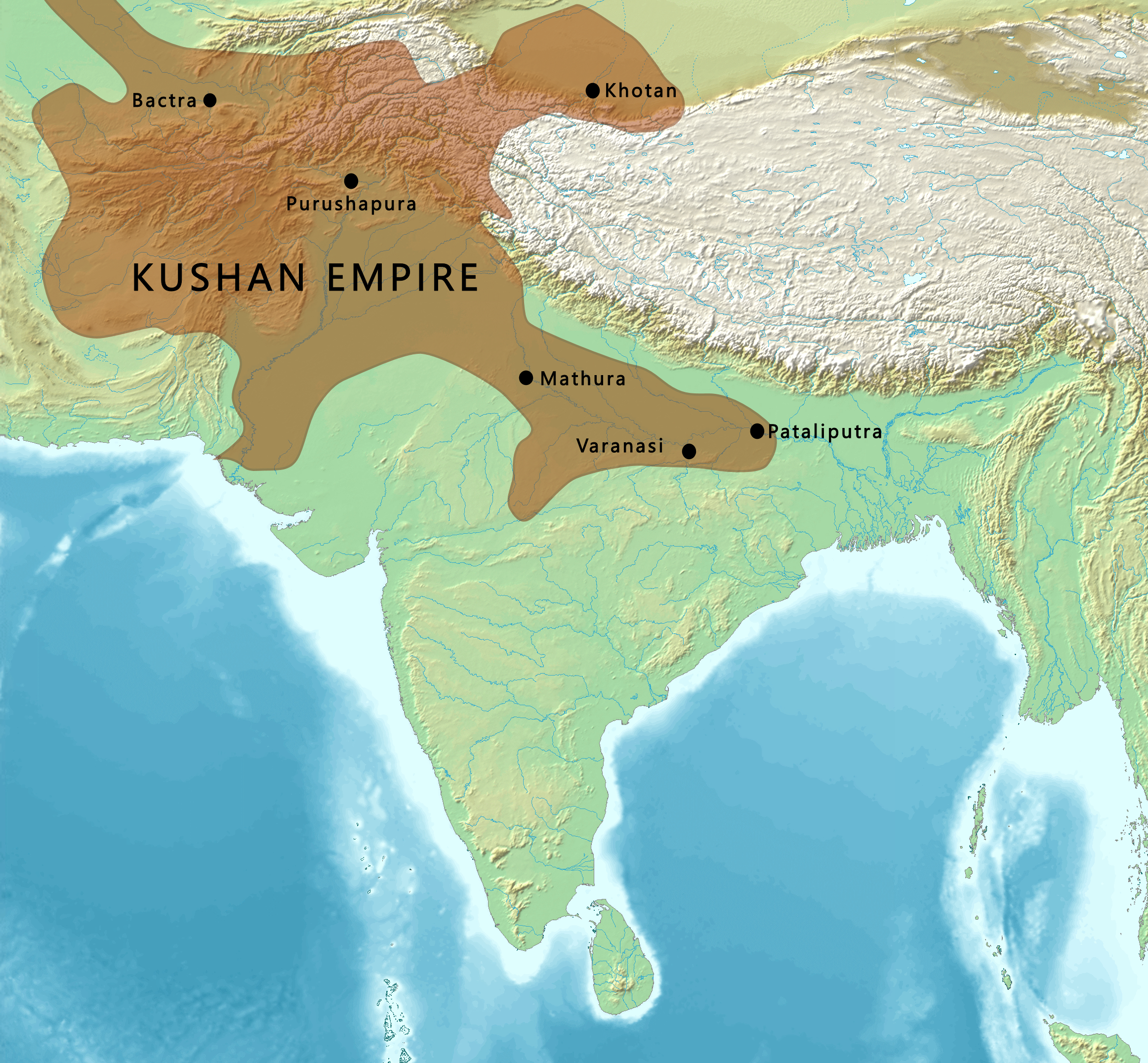
English: Map of the Kushan Empire |
| ရက်စွဲ | |
| ရင်းမြစ် | |
| စာရေးသူ |
Map created from DEMIS Mapserver, which are public domain. Koba-chan. |

လိုင်စင်သတ်မှတ်ခြင်း

|
ဤစာတမ်းကို GNU Free Documentation License, ဗားရှင်း ၁.၂ သို့မဟုတ် Free Software Foundation မှ ဖြန့်ချီထားသော မည်သည့်ယခင်ဗားရှင်းတစ်ခုခုအောက်တွင် Invariant Sections, Front-Cover Texts နှင့် Back-Cover Texts များမပါဝင်ဘဲ ကူးယူခြင်း၊ ဖြန့်ချီခြင်း နှင့်/သို့မဟုတ် ပြင်ဆင်ပြောင်းလဲနိုင်ရန် ခွင့်ပြုသည်။ လိုင်စင်မူပွားကို GNU Free Documentation License ခေါင်းစဉ်အောက်တွင် ထည့်သွင်းထားသည်။ |
| ဤဖိုင်ကို Creative Commons Attribution-Share Alike 3.0 Unported လိုင်စင်ဖြင့် သတ်မှတ်ထားသည်။ | ||
| ||
| This licensing tag was added to this file as part of the GFDL licensing update. |
ဖိုင်မှတ်တမ်း
ဖိုင်ကို ယင်းနေ့စွဲ အတိုင်း မြင်နိုင်ရန် နေ့စွဲ/အချိန် တစ်ခုခုပေါ်တွင် ကလစ်နှိပ်ပါ။
| နေ့စွဲ/အချိန် | နမူနာပုံငယ် | မှတ်တမ်း ဒိုင်မန်းရှင်းများ | အသုံးပြုသူ | မှတ်ချက် | |
|---|---|---|---|---|---|
| ကာလပေါ် | ၁၂:၂၀၊ ၁၈ ဖေဖော်ဝါရီ ၂၀၂၃ | | ၂၃၂၄ × ၂၁၅၁ (၆.၄၆ MB) | पाटलिपुत्र | sat -10% |
| ၁၀:၁၃၊ ၄ မတ် ၂၀၂၂ |  | ၂၃၂၄ × ၂၁၅၁ (၆.၇၆ MB) | पाटलिपुत्र | locations | |
| ၁၀:၀၆၊ ၄ မတ် ၂၀၂၂ |  | ၂၃၂၄ × ၂၁၅၁ (၆.၇၅ MB) | पाटलिपुत्र | Khotan | |
| ၀၉:၂၉၊ ၂၃ ဖေဖော်ဝါရီ ၂၀၂၂ |  | ၂၃၂၄ × ၂၁၅၁ (၆.၆၆ MB) | पाटलिपुत्र | Uploaded a work by Map created from [http://www2.demis.nl/mapserver/mapper.asp DEMIS Mapserver], which are public domain. Koba-chan.<br> Reference: [https://dsal.uchicago.edu/reference/schwartzberg/pager.html?object=182 Schwartzberg Atlas, v. , p. 145. Map g] from {{extracted from|File:South Asia non political, with rivers.jpg}} with UploadWizard |
ဖိုင်သုံးစွဲမှု
ဤဖိုင်ကို အသုံးပြုထားသော စာမျက်နှာများမရှိပါ။
ဂလိုဘယ် ဖိုင်သုံးစွဲမှု
အောက်ပါ အခြားဝီကီများတွင် ဤဖိုင်ကို အသုံးပြုထားသည်-
- el.wikipedia.org တွင် အသုံးပြုမှု
- en.wikipedia.org တွင် အသုံးပြုမှု
- History of Afghanistan
- History of India
- Kabul
- Kushan Empire
- History of Buddhism
- Rabatak inscription
- Nomadic empire
- Mahameghavahana dynasty
- Portal:Afghanistan
- Central Asians in ancient Indian literature
- Northern Satraps
- Gandharan Buddhism
- User:Falcaorib
- User:Northamerica1000/Portals of the world
- User:Կիմա34/sandbox
- es.wikipedia.org တွင် အသုံးပြုမှု
- fa.wikipedia.org တွင် အသုံးပြုမှု
- fr.wikipedia.org တွင် အသုံးပြုမှု
- gu.wikipedia.org တွင် အသုံးပြုမှု
- he.wikipedia.org တွင် အသုံးပြုမှု
- hi.wikipedia.org တွင် အသုံးပြုမှု
- hy.wikipedia.org တွင် အသုံးပြုမှု
- it.wikipedia.org တွင် အသုံးပြုမှု
- ja.wikipedia.org တွင် အသုံးပြုမှု
- ko.wikipedia.org တွင် အသုံးပြုမှု
- lld.wikipedia.org တွင် အသုံးပြုမှု
- ne.wikipedia.org တွင် အသုံးပြုမှု
- sl.wikipedia.org တွင် အသုံးပြုမှု
- ta.wikipedia.org တွင် အသုံးပြုမှု
- tr.wikipedia.org တွင် အသုံးပြုမှု
- vi.wikipedia.org တွင် အသုံးပြုမှု
- zh.wikipedia.org တွင် အသုံးပြုမှု