
ဖိုင်:Map of the Delhi Sultanate.png
ဤနမူနာ၏ အရွယ်အစား - ၆၄၈ × ၆၀၀ ပစ်ဇယ်။ အခြား ပုံရိပ်ပြတ်သားမှု: ၂၅၉ × ၂၄၀ ပစ်ဇယ် | ၅၁၉ × ၄၈၀ ပစ်ဇယ် | ၈၃၀ × ၇၆၈ ပစ်ဇယ် | ၁၁၀၆ × ၁၀၂၄ ပစ်ဇယ် | ၂၃၂၄ × ၂၁၅၁ ပစ်ဇယ်။
မူရင်းဖိုင် (၂၃၂၄ × ၂၁၅၁ pixels, ဖိုင်အရွယ်အစား - ၆.၇၆ MB, MIME အမျိုးအစား image/png)
| ဤဖိုင်သည် Wikimedia Commons မှဖြစ်ပြီး အခြားပရောဂျက်များတွင် သုံးကောင်းသုံးလိမ့်မည်။ ယင်း၏ ဖိုင်အကြောင်းစာမျက်နှာ တွင် ဖော်ပြထားချက်ကို အောက်တွင် ပြထားသည်။ Commons သည် မူပိုင်ခွင့်လွတ်လပ်သော မီဒီယာဖိုင်များ သိုလှောင်ထားရာ နေရာ ဖြစ်သည်။ သင်လည်း ပါဝင်ကူညီနိုင်ပါသည်။ |
အကျဉ်းချုပ်
| ဖော်ပြချက် |
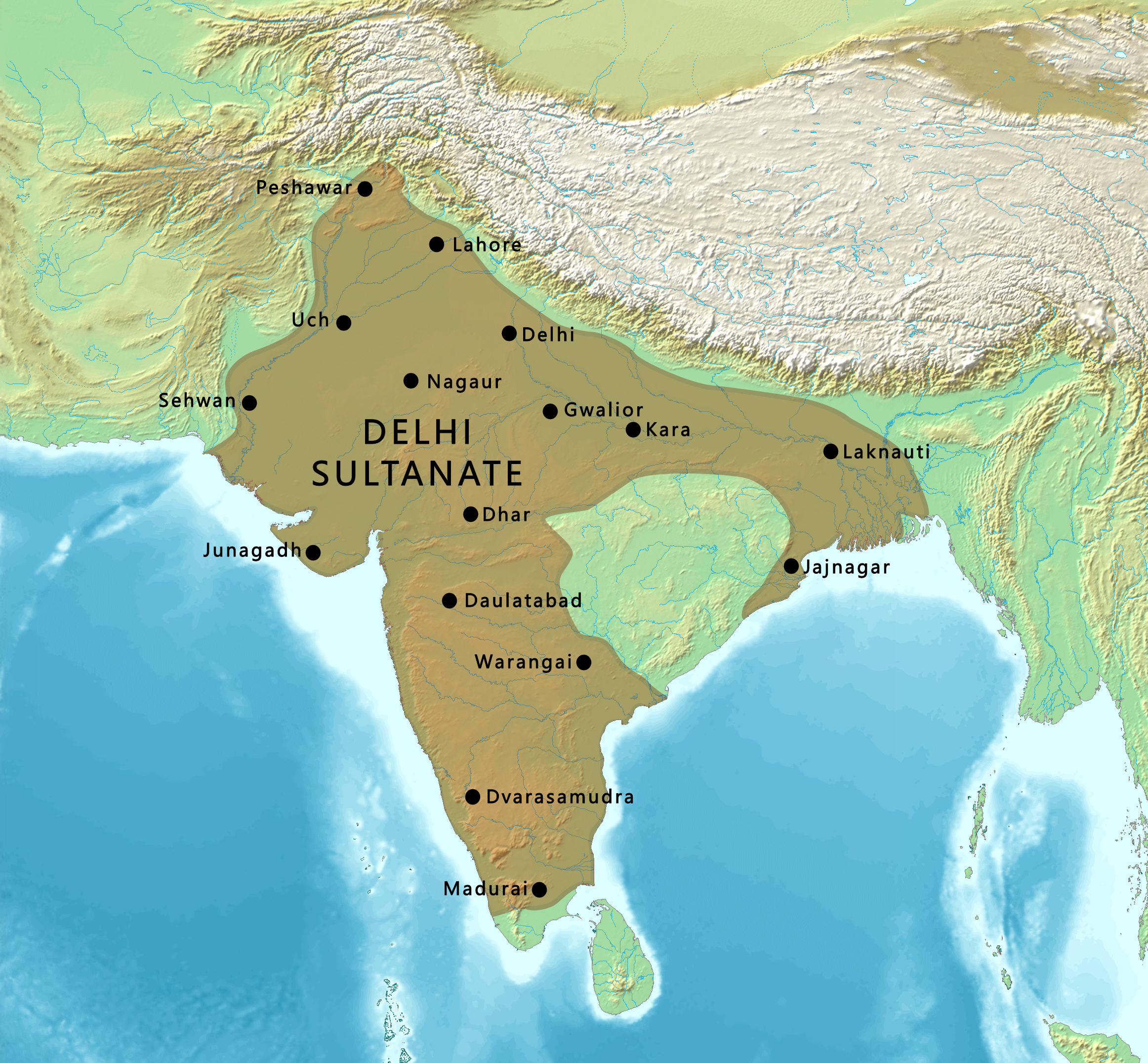
English: Map of the Delhi Sultanate |
| ရက်စွဲ | |
| ရင်းမြစ် | |
| စာရေးသူ |
Maps created from DEMIS Mapserver, which are public domain. Koba-chan |
.png)
လိုင်စင်သတ်မှတ်ခြင်း

|
ဤစာတမ်းကို GNU Free Documentation License, ဗားရှင်း ၁.၂ သို့မဟုတ် Free Software Foundation မှ ဖြန့်ချီထားသော မည်သည့်ယခင်ဗားရှင်းတစ်ခုခုအောက်တွင် Invariant Sections, Front-Cover Texts နှင့် Back-Cover Texts များမပါဝင်ဘဲ ကူးယူခြင်း၊ ဖြန့်ချီခြင်း နှင့်/သို့မဟုတ် ပြင်ဆင်ပြောင်းလဲနိုင်ရန် ခွင့်ပြုသည်။ လိုင်စင်မူပွားကို GNU Free Documentation License ခေါင်းစဉ်အောက်တွင် ထည့်သွင်းထားသည်။ |
| ဤဖိုင်ကို Creative Commons Attribution-Share Alike 3.0 Unported လိုင်စင်ဖြင့် သတ်မှတ်ထားသည်။ | ||
| ||
| This licensing tag was added to this file as part of the GFDL licensing update. |
ဖိုင်မှတ်တမ်း
ဖိုင်ကို ယင်းနေ့စွဲ အတိုင်း မြင်နိုင်ရန် နေ့စွဲ/အချိန် တစ်ခုခုပေါ်တွင် ကလစ်နှိပ်ပါ။
| နေ့စွဲ/အချိန် | နမူနာပုံငယ် | မှတ်တမ်း ဒိုင်မန်းရှင်းများ | အသုံးပြုသူ | မှတ်ချက် | |
|---|---|---|---|---|---|
| ကာလပေါ် | ၁၇:၅၅၊ ၉ မတ် ၂၀၂၃ | | ၂၃၂၄ × ၂၁၅၁ (၆.၇၆ MB) | पाटलिपुत्र | Reverted to version as of 21:34, 5 March 2023 (UTC) |
| ၁၇:၅၄၊ ၉ မတ် ၂၀၂၃ |  | ၂၃၂၄ × ၂၁၅၁ (၆.၇၇ MB) | पाटलिपुत्र | colors | |
| ၂၁:၃၄၊ ၅ မတ် ၂၀၂၃ |  | ၂၃၂၄ × ၂၁၅၁ (၆.၇၆ MB) | पाटलिपुत्र | Coastline | |
| ၁၈:၃၁၊ ၂၈ ဇန်နဝါရီ ၂၀၂၃ |  | ၂၃၂၄ × ၂၁၅၁ (၆.၇၆ MB) | पाटलिपुत्र | Uploaded a work by Maps created from [http://www2.demis.nl/mapserver/mapper.asp DEMIS Mapserver], which are public domain. Koba-chan<br> Territorial area: पाटलिपुत्र (<span class="signature-talk">{{int:Talkpagelinktext}}</span>), per [https://dsal.uchicago.edu/reference/schwartzberg/pager.html?object=186 Schwartberg Atlas p.148] from {{extracted from|File:South Asia (compilation).png}} with UploadWizard |
ဖိုင်သုံးစွဲမှု
ဤဖိုင်ကို အသုံးပြုထားသော စာမျက်နှာများမရှိပါ။
ဂလိုဘယ် ဖိုင်သုံးစွဲမှု
အောက်ပါ အခြားဝီကီများတွင် ဤဖိုင်ကို အသုံးပြုထားသည်-
- en.wikipedia.org တွင် အသုံးပြုမှု
- ko.wikipedia.org တွင် အသုံးပြုမှု
- lv.wikipedia.org တွင် အသုံးပြုမှု
- tr.wikipedia.org တွင် အသုံးပြုမှု