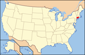
ဖိုင်:Map of USA CT.svg

Size of this PNG preview of this SVG file: ၂၈၆ × ၁၈၆ ပစ်ဇယ်. အခြား ပုံရိပ်ပြတ်သားမှု: ၃၂၀ × ၂၀၈ ပစ်ဇယ် | ၆၄၀ × ၄၁၆ ပစ်ဇယ် | ၁၀၂၄ × ၆၆၆ ပစ်ဇယ် | ၁၂၈၀ × ၈၃၂ ပစ်ဇယ် | ၂၅၆၀ × ၁၆၆၅ ပစ်ဇယ်။
မူရင်းဖိုင် (SVG ဖိုင်, ၂၈၆ × ၁၈၆ pixels ကို အကြံပြုသည်, ဖိုင်အရွယ်အစား - ၁၆၇ KB)
ဖိုင်မှတ်တမ်း
ဖိုင်ကို ယင်းနေ့စွဲ အတိုင်း မြင်နိုင်ရန် နေ့စွဲ/အချိန် တစ်ခုခုပေါ်တွင် ကလစ်နှိပ်ပါ။
| နေ့စွဲ/အချိန် | နမူနာပုံငယ် | မှတ်တမ်း ဒိုင်မန်းရှင်းများ | အသုံးပြုသူ | မှတ်ချက် | |
|---|---|---|---|---|---|
| ကာလပေါ် | ၀၉:၀၆၊ ၂၆ ဧပြီ ၂၀၀၈ |  | ၂၈၆ × ၁၈၆ (၁၆၇ KB) | Rub1615~commonswiki | Reverted to version as of 14:28, 27 May 2006 |
| ၁၄:၅၀၊ ၂၃ ဧပြီ ၂၀၀၈ |  | ၂၈၆ × ၁၈၆ (၁၇၈ KB) | Rfc1394 | Add an inset to the map enlarging the focus area to make it easier to see the designated state. | |
| ၁၄:၂၈၊ ၂၇ မေ ၂၀၀၆ |  | ၂၈၆ × ၁၈၆ (၁၆၇ KB) | Huebi~commonswiki | {{Information| |Description=Map of USA with Connecticut highlighted |other_versions=image:Map of USA with state names.svg }} Category:Maps of the United States Category:Maps of Connecticut Category:SVG maps {{GFDL-en}}{{cc-by-2.0}}{{cc- |
ဖိုင်သုံးစွဲမှု
ဤဖိုင်ကို အသုံးပြုထားသော စာမျက်နှာများမရှိပါ။
ဂလိုဘယ် ဖိုင်သုံးစွဲမှု
အောက်ပါ အခြားဝီကီများတွင် ဤဖိုင်ကို အသုံးပြုထားသည်-
- af.wikipedia.org တွင် အသုံးပြုမှု
- ang.wikipedia.org တွင် အသုံးပြုမှု
- arc.wikipedia.org တွင် အသုံးပြုမှု
- az.wiktionary.org တွင် အသုံးပြုမှု
- ban.wikipedia.org တွင် အသုံးပြုမှု
- bcl.wikipedia.org တွင် အသုံးပြုမှု
- be-tarask.wikipedia.org တွင် အသုံးပြုမှု
- bg.wikipedia.org တွင် အသုံးပြုမှု
- bi.wikipedia.org တွင် အသုံးပြုမှု
- bpy.wikipedia.org တွင် အသုံးပြုမှု
- bxr.wikipedia.org တွင် အသုံးပြုမှု
- ca.wikipedia.org တွင် အသုံးပြုမှု
- ce.wikipedia.org တွင် အသုံးပြုမှု
- cs.wikipedia.org တွင် အသုံးပြုမှု
- cs.wikinews.org တွင် အသုံးပြုမှု
- cv.wikipedia.org တွင် အသုံးပြုမှု
- da.wikipedia.org တွင် အသုံးပြုမှု
- de.wikipedia.org တွင် အသုံးပြုမှု
- Benutzer:Wolfgang1018/Wikipedia-Quiz
- Kategorie:Connecticut
- Vorwahlergebnisse der Präsidentschaftswahl in den Vereinigten Staaten 2008
- Weinbau in Connecticut
- Flaggen und Siegel der US-Bundesstaaten
- Vorwahlergebnisse der Präsidentschaftswahl in den Vereinigten Staaten 2016
- Vorwahlergebnisse der Präsidentschaftswahl in den Vereinigten Staaten 2020
- Vorwahlergebnisse der Präsidentschaftswahl in den Vereinigten Staaten 2024
- de.wiktionary.org တွင် အသုံးပြုမှု
- el.wikipedia.org တွင် အသုံးပြုမှု
- en.wikipedia.org တွင် အသုံးပြုမှု
ဤဖိုင်ကို အခြားနေရာများတွင် အသုံးပြုထားမှုများအား ကြည့်ရှုရန်။


