
ဖိုင်:Map of North America with the Western Interior Seaway during the Campanian (Upper Cretaceous).png

ဤနမူနာ၏ အရွယ်အစား - ၄၈၈ × ၆၀၀ ပစ်ဇယ်။ အခြား ပုံရိပ်ပြတ်သားမှု: ၁၉၅ × ၂၄၀ ပစ်ဇယ် | ၃၉၀ × ၄၈၀ ပစ်ဇယ် | ၆၂၅ × ၇၆၈ ပစ်ဇယ် | ၈၃၃ × ၁၀၂၄ ပစ်ဇယ် | ၁၉၄၅ × ၂၃၉၁ ပစ်ဇယ်။
မူရင်းဖိုင် (၁၉၄၅ × ၂၃၉၁ pixels, ဖိုင်အရွယ်အစား - ၃.၉၅ MB, MIME အမျိုးအစား image/png)
| ဤဖိုင်သည် Wikimedia Commons မှဖြစ်ပြီး အခြားပရောဂျက်များတွင် သုံးကောင်းသုံးလိမ့်မည်။ ယင်း၏ ဖိုင်အကြောင်းစာမျက်နှာ တွင် ဖော်ပြထားချက်ကို အောက်တွင် ပြထားသည်။ Commons သည် မူပိုင်ခွင့်လွတ်လပ်သော မီဒီယာဖိုင်များ သိုလှောင်ထားရာ နေရာ ဖြစ်သည်။ သင်လည်း ပါဝင်ကူညီနိုင်ပါသည်။ |
.png)
အကျဉ်းချုပ်
| ဖော်ပြချက် |
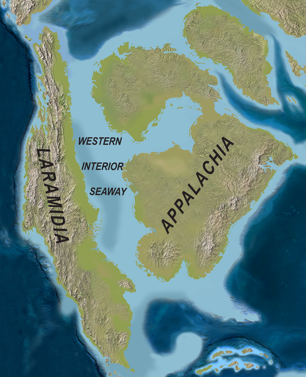
English: Map of North America with the Western Interior Seaway during the Campanian (Upper Cretaceous). Paleogeography of North America during the late Campanian Stage of the Late Cretaceous (∼75 Ma). Modified after Blakey.
Deutsch: Karte von Nordamerika mit dem Western Interior Seaway während des Campaniums (Obere Kreide) |
| ရက်စွဲ | |
| ရင်းမြစ် | http://www.plosone.org/article/info%3Adoi%2F10.1371%2Fjournal.pone.0012292 |
| စာရေးသူ | Scott D. Sampson, Mark A. Loewen, Andrew A. Farke, Eric M. Roberts, Catherine A. Forster, Joshua A. Smith, Alan L. Titus |
| ခွင့်ပြုချက် (ဤဖိုင်ကို ပြန်လည်အသုံးပြုခြင်း) |
http://www.plosbiology.org/static/license.action |
လိုင်စင်သတ်မှတ်ခြင်း
ဤဖိုင်သည် Creative Commons Attribution 4.0 နိုင်ငံတကာ လိုင်စင်အောက်တွင် လိုင်စင်သတ်မှတ်ထားပါသည်။
- သင်သည် လွတ်လပ်စွာ:
- မျှဝေရန် – ဖန်တီးမှုကို ကူးယူရန်၊ ဖြန့်ဖြူးရန်နှင့် ထုတ်လွှင့်ရန်
- ပြန်ရောနှောရန် – ဖန်တီးမှုကို ပြင်ဆင်ညှိနှိုင်းရန်
- အောက်ပါ အခြေအနေများတွင်:
- မှတ်ယူနိုင်ခြင်း – ပြောင်းလဲမှုများ ပြုလုပ်ခဲ့ပါက ဖန်တီးသူ သို့မဟုတ် လိုင်စင်ရှိသူမှ သတ်မှတ်သော အမျိုးအစားကို လိုက်နာရမည် (ဆိုလိုသည်မှာ သင့်အား သို့မဟုတ် သင့်ဖန်တီးမှုတွင် အသုံးပြုခြင်းအား ထောက်ခံချက်ပေးသည်ဟု မဆိုလိုပါ)။
ဖိုင်မှတ်တမ်း
ဖိုင်ကို ယင်းနေ့စွဲ အတိုင်း မြင်နိုင်ရန် နေ့စွဲ/အချိန် တစ်ခုခုပေါ်တွင် ကလစ်နှိပ်ပါ။
| နေ့စွဲ/အချိန် | နမူနာပုံငယ် | မှတ်တမ်း ဒိုင်မန်းရှင်းများ | အသုံးပြုသူ | မှတ်ချက် | |
|---|---|---|---|---|---|
| ကာလပေါ် | ၂၁:၀၈၊ ၁ ဧပြီ ၂၀၂၀ | | ၁၉၄၅ × ၂၃၉၁ (၃.၉၅ MB) | FunkMonk | {{Information |Description = {{en|1=Map of North America with the Western Interior Seaway during the Campanian (Upper Cretaceous). Paleogeography of North America during the late Campanian Stage of the Late Cretaceous (∼75 Ma). Modified after Blakey.}} {{de|1=Karte von Nordamerika mit dem Western Interior Seaway während des Campaniums (Obere Kreide)}} |Source =http://www.plosone.org/article/info%3Adoi%2F10.1371%2Fjournal.pone.0012292 |Author =Scott D. Sampson, Mark A. Loewe... |
ဖိုင်သုံးစွဲမှု
ဤဖိုင်ကို အသုံးပြုထားသော စာမျက်နှာများမရှိပါ။
ဂလိုဘယ် ဖိုင်သုံးစွဲမှု
အောက်ပါ အခြားဝီကီများတွင် ဤဖိုင်ကို အသုံးပြုထားသည်-
- de.wiktionary.org တွင် အသုံးပြုမှု
- en.wikipedia.org တွင် အသုံးပြုမှု
- fa.wikipedia.org တွင် အသုံးပြုမှု
- fr.wikipedia.org တွင် အသုံးပြုမှု
- id.wikipedia.org တွင် အသုံးပြုမှု
- it.wikipedia.org တွင် အသုံးပြုမှု
- ne.wikipedia.org တွင် အသုံးပြုမှု
- nl.wikipedia.org တွင် အသုံးပြုမှု
- pl.wikipedia.org တွင် အသုံးပြုမှု
- pl.wiktionary.org တွင် အသုံးပြုမှု
- pt.wikipedia.org တွင် အသုံးပြုမှု
- ru.wikipedia.org တွင် အသုံးပြုမှု
- tr.wikipedia.org တွင် အသုံးပြုမှု
- uk.wikipedia.org တွင် အသုံးပြုမှု
- zh.wikipedia.org တွင် အသုံးပြုမှု
.png)