
ဖိုင်:Map of British North Borneo, yellow area covered by the Philippine claim.PNG
Map_of_British_North_Borneo,_yellow_area_covered_by_the_Philippine_claim.PNG (၅၇၀ × ၄၃၈ pixels, ဖိုင်အရွယ်အစား - ၅၅၂ KB, MIME အမျိုးအစား image/png)
| ဤဖိုင်သည် Wikimedia Commons မှဖြစ်ပြီး အခြားပရောဂျက်များတွင် သုံးကောင်းသုံးလိမ့်မည်။ ယင်း၏ ဖိုင်အကြောင်းစာမျက်နှာ တွင် ဖော်ပြထားချက်ကို အောက်တွင် ပြထားသည်။ Commons သည် မူပိုင်ခွင့်လွတ်လပ်သော မီဒီယာဖိုင်များ သိုလှောင်ထားရာ နေရာ ဖြစ်သည်။ သင်လည်း ပါဝင်ကူညီနိုင်ပါသည်။ |
| ဖော်ပြချက် |
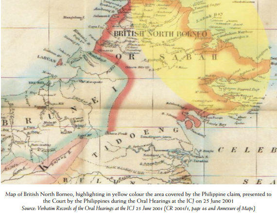
English: Map of British North Borneo, highlighting in yellow colour the area covered by the Philippine claim, presented to the Court by the Philippines during the Oral Hearings at the ICJ on 25 June 2001 Source: Verbatim Records of the Oral Hearings at the ICJ 25 June 2001 (CR 2001/1, page 46 and Annexure of Maps) |
|||||||
| ရက်စွဲ | Map since 18th century (Presented by the Philippines to ICJ on 25 June 2001) | |||||||
| ရင်းမြစ် | Map of British North Borneo, highlighting in yellow colour the area covered by the Philippine claim, presented to the Court by the Philippines during the Oral Hearings at the ICJ on 25 June 2001 | |||||||
| စာရေးသူ | မသိရှိရ | |||||||
| ခွင့်ပြုချက် (ဤဖိုင်ကို ပြန်လည်အသုံးပြုခြင်း) |
|
|||||||

ဖိုင်မှတ်တမ်း
ဖိုင်ကို ယင်းနေ့စွဲ အတိုင်း မြင်နိုင်ရန် နေ့စွဲ/အချိန် တစ်ခုခုပေါ်တွင် ကလစ်နှိပ်ပါ။
| နေ့စွဲ/အချိန် | နမူနာပုံငယ် | မှတ်တမ်း ဒိုင်မန်းရှင်းများ | အသုံးပြုသူ | မှတ်ချက် | |
|---|---|---|---|---|---|
| ကာလပေါ် | ၁၄:၅၀၊ ၁၆ မေ ၂၀၁၄ | | ၅၇၀ × ၄၃၈ (၅၅၂ KB) | Muffin Wizard | {{Information |Description ={{en|1=Map of British North Borneo, highlighting in yellow colour the area covered by the Philippine claim, presented to the Court by the Philippines during the Oral Hearings at the ICJ on 25 June 2001 Source: Verbatim Re... |
ဖိုင်သုံးစွဲမှု
ဤဖိုင်ကို အသုံးပြုထားသော စာမျက်နှာများမရှိပါ။
ဂလိုဘယ် ဖိုင်သုံးစွဲမှု
အောက်ပါ အခြားဝီကီများတွင် ဤဖိုင်ကို အသုံးပြုထားသည်-
- en.wikipedia.org တွင် အသုံးပြုမှု
- pt.wikipedia.org တွင် အသုံးပြုမှု