
ဖိုင်:Map achaemenid empire en.png

မူရင်းဖိုင် (၁၆၇၆ × ၈၆၉ pixels, ဖိုင်အရွယ်အစား - ၃၇၆ KB, MIME အမျိုးအစား image/png)
| ဤဖိုင်သည် Wikimedia Commons မှဖြစ်ပြီး အခြားပရောဂျက်များတွင် သုံးကောင်းသုံးလိမ့်မည်။ ယင်း၏ ဖိုင်အကြောင်းစာမျက်နှာ တွင် ဖော်ပြထားချက်ကို အောက်တွင် ပြထားသည်။ Commons သည် မူပိုင်ခွင့်လွတ်လပ်သော မီဒီယာဖိုင်များ သိုလှောင်ထားရာ နေရာ ဖြစ်သည်။ သင်လည်း ပါဝင်ကူညီနိုင်ပါသည်။ |
အကျဉ်းချုပ်
| ဖော်ပြချက် |
လိုင်စင်သတ်မှတ်ခြင်းကျွန်ုပ်၊ ဤလုပ်ဆောင်ချက်၏ မူပိုင်ခွင့်ပိုင်ရှင်အနေဖြင့် ဤနေရာမှ အောက်ပါလိုင်စင်အောက်တွင် ထုတ်လွှင့်ပါသည်: ဤဖိုင်သည် Creative Commons Attribution-Share Alike 2.5 Generic, 2.0 Generic and 1.0 Generic လိုင်စင်အောက်တွင် လိုင်စင်သတ်မှတ်ထားပါသည်။
|
||||||||||||
|
|
Note : Description : |
||||||||||||


See also French version: Image:Carte empire achéménide.png See also Hungarian svg version: image:Map achaemenid empire hu.svg
ဖိုင်မှတ်တမ်း
ဖိုင်ကို ယင်းနေ့စွဲ အတိုင်း မြင်နိုင်ရန် နေ့စွဲ/အချိန် တစ်ခုခုပေါ်တွင် ကလစ်နှိပ်ပါ။
| နေ့စွဲ/အချိန် | နမူနာပုံငယ် | မှတ်တမ်း ဒိုင်မန်းရှင်းများ | အသုံးပြုသူ | မှတ်ချက် | |
|---|---|---|---|---|---|
| ကာလပေါ် | ၀၄:၃၅၊ ၁၉ နိုဝင်ဘာ ၂၀၁၇ | | ၁၆၇၆ × ၈၆၉ (၃၇၆ KB) | R9tgokunks | Reverted to version as of 00:35, 14 October 2015 (UTC) |
| ၀၈:၃၆၊ ၂၄ အောက်တိုဘာ ၂၀၁၇ |  | ၁၆၇၆ × ၈၆၉ (၄၅၀ KB) | Mehrdad 12 | Reverted to version as of 21:38, 10 August 2015 (UTC) | |
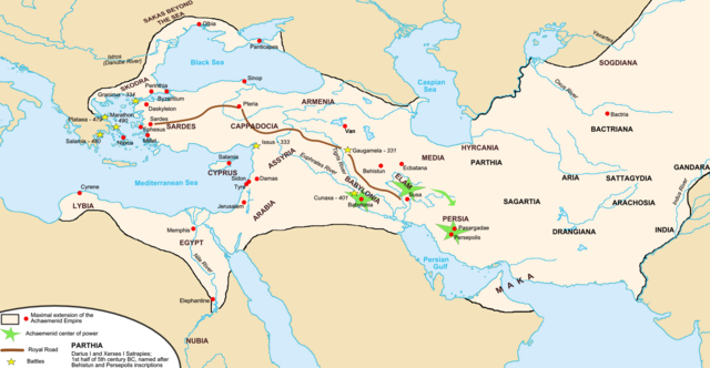
| ၀၀:၃၅၊ ၁၄ အောက်တိုဘာ ၂၀၁၅ |  | ၁၆၇၆ × ၈၆၉ (၃၇၆ KB) | LouisAragon | For the last time; they did NOT conquer territoiry past the Indus River border as of on this map. | |
| ၀၀:၀၂၊ ၁၂ အောက်တိုဘာ ၂၀၁၅ |  | ၁၆၇၆ × ၈၆၄ (၄၈၄ KB) | History of Persia | Macedonia | |
| ၂၃:၅၈၊ ၁၁ အောက်တိုဘာ ၂၀၁၅ |  | ၁၆၇၆ × ၈၆၉ (၄၄၆ KB) | History of Persia | Yeah their included but the borders are innacurrate. Arabia extended deeper and the indus river itself was not the border itself. | |
| ၀၂:၃၃၊ ၁၁ အောက်တိုဘာ ၂၀၁၅ |  | ၁၆၇၆ × ၈၆၉ (၃၇၆ KB) | LouisAragon | The Indus and Northern Arabia are already included. Bring your concerns (with sources) to the Wikipedia talk page. | |
| ၀၄:၄၅၊ ၁၄ ဩဂုတ် ၂၀၁၅ |  | ၁၆၇၆ × ၈၆၉ (၄၄၆ KB) | History of Persia | better | |
| ၂၁:၃၈၊ ၁၀ ဩဂုတ် ၂၀၁၅ |  | ၁၆၇၆ × ၈၆၉ (၄၅၀ KB) | History of Persia | darius conquered the indus and arabia | |
| ၂၁:၃၈၊ ၁၀ ဩဂုတ် ၂၀၁၅ |  | ၁၆၇၆ × ၈၆၉ (၄၅၀ KB) | History of Persia | darius conquered the indus and arabia | |
| ၂၁:၃၇၊ ၁၀ ဩဂုတ် ၂၀၁၅ |  | ၁၆၇၆ × ၈၆၉ (၄၅၀ KB) | History of Persia | darius conquered the indus and arabia |
ဖိုင်သုံးစွဲမှု
ဤဖိုင်ကို အသုံးပြုထားသော စာမျက်နှာများမရှိပါ။
ဂလိုဘယ် ဖိုင်သုံးစွဲမှု
အောက်ပါ အခြားဝီကီများတွင် ဤဖိုင်ကို အသုံးပြုထားသည်-
- als.wikipedia.org တွင် အသုံးပြုမှု
- ar.wikipedia.org တွင် အသုံးပြုမှု
- ast.wikipedia.org တွင် အသုံးပြုမှု
- av.wikipedia.org တွင် အသုံးပြုမှု
- azb.wikipedia.org တွင် အသုံးပြုမှု
- az.wikipedia.org တွင် အသုံးပြုမှု
- ba.wikipedia.org တွင် အသုံးပြုမှု
- be.wikipedia.org တွင် အသုံးပြုမှု
- bg.wikipedia.org တွင် အသုံးပြုမှု
- bs.wikipedia.org တွင် အသုံးပြုမှု
- bxr.wikipedia.org တွင် အသုံးပြုမှု
- ca.wikipedia.org တွင် အသုံးပြုမှု
- cs.wikipedia.org တွင် အသုံးပြုမှု
- de.wikipedia.org တွင် အသုံးပြုမှု
- diq.wikipedia.org တွင် အသုံးပြုမှု
- el.wikipedia.org တွင် အသုံးပြုမှု
- en.wikipedia.org တွင် အသုံးပြုမှု
- Empire
- Talk:Iran/Archive 10
- Timeline of Jerusalem
- List of conflicts in Asia
- User talk:SG/Archive1
- Template talk:History of Afghanistan
- User:Ottava Rima/Persian Empire
- User:John K/Persian Empire
- Talk:Achaemenid Empire/Archive 1
- List of ancient great powers
- User:Falcaorib
- Wikipedia:Graphics Lab/Map workshop/Archive/Mar 2020
- en.wikibooks.org တွင် အသုံးပြုမှု
- en.wiktionary.org တွင် အသုံးပြုမှု
- eo.wikipedia.org တွင် အသုံးပြုမှု
- es.wikipedia.org တွင် အသုံးပြုမှု
- eu.wikipedia.org တွင် အသုံးပြုမှု
ဤဖိုင်ကို အခြားနေရာများတွင် အသုံးပြုထားမှုများအား ကြည့်ရှုရန်။