
ဖိုင်:LocationOceania.png

ဤနမူနာ၏ အရွယ်အစား - ၈၀၀ × ၄၀၇ ပစ်ဇယ်။ အခြား ပုံရိပ်ပြတ်သားမှု: ၃၂၀ × ၁၆၃ ပစ်ဇယ် | ၆၄၀ × ၃၂၆ ပစ်ဇယ် | ၁၀၂၄ × ၅၂၁ ပစ်ဇယ် | ၁၂၈၀ × ၆၅၁ ပစ်ဇယ် | ၂၇၅၉ × ၁၄၀၄ ပစ်ဇယ်။
မူရင်းဖိုင် (၂၇၅၉ × ၁၄၀၄ pixels, ဖိုင်အရွယ်အစား - ၉၈ KB, MIME အမျိုးအစား image/png)
| ဤဖိုင်သည် Wikimedia Commons မှဖြစ်ပြီး အခြားပရောဂျက်များတွင် သုံးကောင်းသုံးလိမ့်မည်။ ယင်း၏ ဖိုင်အကြောင်းစာမျက်နှာ တွင် ဖော်ပြထားချက်ကို အောက်တွင် ပြထားသည်။ Commons သည် မူပိုင်ခွင့်လွတ်လပ်သော မီဒီယာဖိုင်များ သိုလှောင်ထားရာ နေရာ ဖြစ်သည်။ သင်လည်း ပါဝင်ကူညီနိုင်ပါသည်။ |
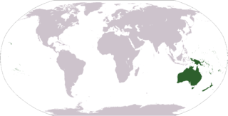
World map depicting Oceania; map adapted from PDF world map at CIA World Fact Book
Light Green: Regions often included in Oceania

|
File:LocationOceania.svg is a vector version of this file. It should be used in place of this PNG file when not inferior.
File:LocationOceania.png → File:LocationOceania.svg
For more information, see Help:SVG. |
 |
This image is in the public domain because it contains materials that originally came from the United States Central Intelligence Agency's World Factbook.
|
 |
derivative works
Derivative works of this file: Wikinews Australia i Oceania mapa.png
ဖိုင်မှတ်တမ်း
ဖိုင်ကို ယင်းနေ့စွဲ အတိုင်း မြင်နိုင်ရန် နေ့စွဲ/အချိန် တစ်ခုခုပေါ်တွင် ကလစ်နှိပ်ပါ။
| နေ့စွဲ/အချိန် | နမူနာပုံငယ် | မှတ်တမ်း ဒိုင်မန်းရှင်းများ | အသုံးပြုသူ | မှတ်ချက် | |
|---|---|---|---|---|---|
| ကာလပေါ် | ၀၂:၃၈၊ ၁၅ မတ် ၂၀၀၈ | | ၂၇၅၉ × ၁၄၀၄ (၉၈ KB) | Corticopious | Reverted to version as of 12:42, 19 January 2008 |
| ၁၄:၄၂၊ ၁၀ ဖေဖော်ဝါရီ ၂၀၀၈ |  | ၂၇၅၉ × ၁၄၀၄ (၁၆၁ KB) | Luis wiki | {{PD-USGov-CIA-WF}} | |
| ၁၂:၄၂၊ ၁၉ ဇန်နဝါရီ ၂၀၀၈ |  | ၂၇၅၉ × ၁၄၀၄ (၉၈ KB) | F l a n k e r | Transparency | |
| ၁၃:၄၃၊ ၁ အောက်တိုဘာ ၂၀၀၆ |  | ၂၇၅၉ × ၁၄၀၄ (၅၅ KB) | Cogito ergo sumo~commonswiki | World map: Oceania (location) | |
| ၂၁:၀၈၊ ၂ စက်တင်ဘာ ၂၀၀၆ |  | ၂၇၅၉ × ၁၄၀၄ (၅၅ KB) | Cogito ergo sumo~commonswiki | World map: Oceania (location) | |
| ၀၇:၃၅၊ ၃၀ ဇန်နဝါရီ ၂၀၀၆ |  | ၂၇၅၉ × ၁၄၀၄ (၅၅ KB) | E Pluribus Anthony~commonswiki | World map: Oceania (location) | |
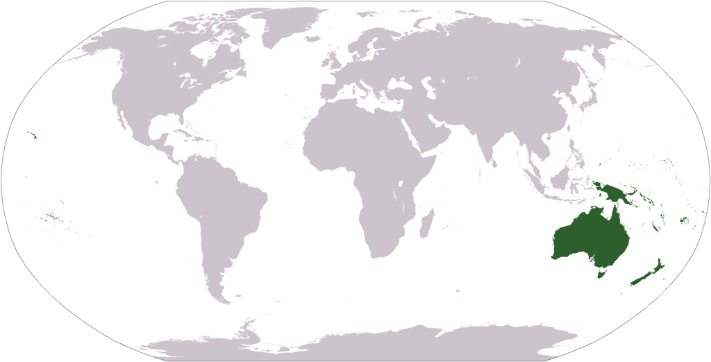
| ၁၇:၀၅၊ ၁၀ အောက်တိုဘာ ၂၀၀၅ |  | ၂၇၅၉ × ၁၄၀၄ (၅၅ KB) | Carlosar~commonswiki | Oceania's place in the world. Category:Continent locator maps |
ဖိုင်သုံးစွဲမှု
ဤဖိုင်ကို အသုံးပြုထားသော စာမျက်နှာများမရှိပါ။
ဂလိုဘယ် ဖိုင်သုံးစွဲမှု
အောက်ပါ အခြားဝီကီများတွင် ဤဖိုင်ကို အသုံးပြုထားသည်-
- af.wikipedia.org တွင် အသုံးပြုမှု
- Australasië
- Midde-Ooste
- Sentraal-Amerika
- Atlantiese Oseaan
- Suider-Afrika
- Indiese Oseaan
- Suidelike Oseaan
- Arktiese Oseaan
- Nederlandse koloniale ryk
- Stille Oseaan
- Latyns-Amerika
- Oos-Asië
- Sjabloon:Gebiede van die wêreld
- Noord-Europa
- Melanesië
- Mikronesië
- Polinesië
- Oos-Afrika
- Wes-Afrika
- Noord-Afrika
- Oos-Europa
- Verre Ooste
- Sentraal-Afrika
- Afrika suid van die Sahara
- Seelandië
- Noordpoolgebied
- Karibiese gebied
- Indiese subkontinent
- Suidoos-Asië
- Wes-Asië
- Wes-Europa
- Suid-Europa
- Suid-Asië
- Sentraal-Asië
- Sentraal-Europa
- Suidoos-Europa
- Noord-Asië
- am.wikipedia.org တွင် အသုံးပြုမှု
- arc.wikipedia.org တွင် အသုံးပြုမှု
ဤဖိုင်ကို အခြားနေရာများတွင် အသုံးပြုထားမှုများအား ကြည့်ရှုရန်။