
ဖိုင်:Kensington and Chelsea London UK location map.svg

Size of this PNG preview of this SVG file: ၅၆၃ × ၆၀၀ ပစ်ဇယ်. အခြား ပုံရိပ်ပြတ်သားမှု: ၂၂၅ × ၂၄၀ ပစ်ဇယ် | ၄၅၀ × ၄၈၀ ပစ်ဇယ် | ၇၂၁ × ၇၆၈ ပစ်ဇယ် | ၉၆၁ × ၁၀၂၄ ပစ်ဇယ် | ၁၉၂၂ × ၂၀၄၈ ပစ်ဇယ် | ၁၁၈၈ × ၁၂၆၆ ပစ်ဇယ်။
မူရင်းဖိုင် (SVG ဖိုင်, ၁၁၈၈ × ၁၂၆၆ pixels ကို အကြံပြုသည်, ဖိုင်အရွယ်အစား - ၂.၀၆ MB)
| ဤဖိုင်သည် Wikimedia Commons မှဖြစ်ပြီး အခြားပရောဂျက်များတွင် သုံးကောင်းသုံးလိမ့်မည်။ ယင်း၏ ဖိုင်အကြောင်းစာမျက်နှာ တွင် ဖော်ပြထားချက်ကို အောက်တွင် ပြထားသည်။ Commons သည် မူပိုင်ခွင့်လွတ်လပ်သော မီဒီယာဖိုင်များ သိုလှောင်ထားရာ နေရာ ဖြစ်သည်။ သင်လည်း ပါဝင်ကူညီနိုင်ပါသည်။ |
| ဖော်ပြချက် |
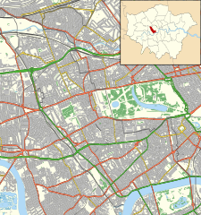
Location map of the Royal Borough of Kensington and Chelsea with the following information shown:
Equirectangular map projection on WGS 84 datum, with N/S stretched 160% Geographic limits:
|
| ရက်စွဲ | |
| ရင်းမြစ် |
|
| စာရေးသူ | Nilfanion |
| ခွင့်ပြုချက် (ဤဖိုင်ကို ပြန်လည်အသုံးပြုခြင်း) |
ဤဖိုင်ကို Creative Commons Attribution-Share Alike 3.0 Unported လိုင်စင်ဖြင့် သတ်မှတ်ထားသည်။ မှတ်ယူနိုင်ခြင်း: Contains Ordnance Survey data © Crown copyright and database right
|
ဖိုင်မှတ်တမ်း
ဖိုင်ကို ယင်းနေ့စွဲ အတိုင်း မြင်နိုင်ရန် နေ့စွဲ/အချိန် တစ်ခုခုပေါ်တွင် ကလစ်နှိပ်ပါ။
| နေ့စွဲ/အချိန် | နမူနာပုံငယ် | မှတ်တမ်း ဒိုင်မန်းရှင်းများ | အသုံးပြုသူ | မှတ်ချက် | |
|---|---|---|---|---|---|
| ကာလပေါ် | ၂၃:၁၁၊ ၁၅ နိုဝင်ဘာ ၂၀၁၁ | | ၁၁၈၈ × ၁၂၆၆ (၂.၀၆ MB) | Nilfanion | {{Information |Description=Location map of the Royal Borough of Kensington and Chelsea with the following information shown: *{{legend|#646464|Ward boundaries}} *{{legend|#667fff|Motorways}} *{{legend|#4cb336| |
ဖိုင်သုံးစွဲမှု
အောက်ပါ 2 စာမျက်နှာများ သည် ဤဖိုင်ကို အသုံးပြုထားသည်:
ဂလိုဘယ် ဖိုင်သုံးစွဲမှု
အောက်ပါ အခြားဝီကီများတွင် ဤဖိုင်ကို အသုံးပြုထားသည်-
- ar.wikipedia.org တွင် အသုံးပြုမှု
- ceb.wikipedia.org တွင် အသုံးပြုမှု
- en.wikipedia.org တွင် အသုံးပြုမှု
- Portobello Road
- Trellick Tower
- Design Museum
- Carlyle's House
- Leighton House Museum
- Royal Brompton Hospital
- Royal Marsden Hospital
- Cromwell Hospital
- Michelin House
- London Cage
- The Tower House
- Chelsea and Westminster Hospital
- Lister Hospital, Chelsea
- St Mary Abbots Hospital
- Restaurant Gordon Ramsay
- Allen Hall Seminary
- Module:Location map/data/United Kingdom London Kensington and Chelsea/doc
- The World's End, Chelsea
- Prince of Teck, Earl's Court
- The Hollywood Arms, Kensington
- Windsor Castle, Kensington
- Elgin, Ladbroke Grove
- Holland House
- Cadogan Pier
- Fox and Pheasant
- The King's Head and Eight Bells
- The Cross Keys, Chelsea
- The Phene
- The Hansom Cab
- Scarsdale Tavern
- Church of Our Most Holy Redeemer and St Thomas More, Chelsea
- Kensington Town Hall, London
- Chelsea Potter
- Zetland Arms
- The Goat, Kensington
- User:Chickstarr404/Gather lists/14617 – "Melbourne" by Lord David Cecil
- Goat, Chelsea
- Victoria Hospital for Children
- Gloucester Arms, Kensington
- The Greyhound, Kensington
- Anglesea Arms, South Kensington
- Bunch of Grapes, Knightsbridge
- Grenfell Tower fire
- Grenfell Tower
- Hollywood Road, Brompton
- Module:Location map/data/United Kingdom London Kensington and Chelsea
ဤဖိုင်ကို အခြားနေရာများတွင် အသုံးပြုထားမှုများအား ကြည့်ရှုရန်။