
ဖိုင်:IsraelCVFRchart-BorderNorth copy.jpg

မူရင်းဖိုင် (၁၃၀၈ × ၁၇၇၂ pixels, ဖိုင်အရွယ်အစား - ၂.၀၁ MB, MIME အမျိုးအစား image/jpeg)
| ဤဖိုင်သည် Wikimedia Commons မှဖြစ်ပြီး အခြားပရောဂျက်များတွင် သုံးကောင်းသုံးလိမ့်မည်။ ယင်း၏ ဖိုင်အကြောင်းစာမျက်နှာ တွင် ဖော်ပြထားချက်ကို အောက်တွင် ပြထားသည်။ Commons သည် မူပိုင်ခွင့်လွတ်လပ်သော မီဒီယာဖိုင်များ သိုလှောင်ထားရာ နေရာ ဖြစ်သည်။ သင်လည်း ပါဝင်ကူညီနိုင်ပါသည်။ |
| ဖော်ပြချက် |
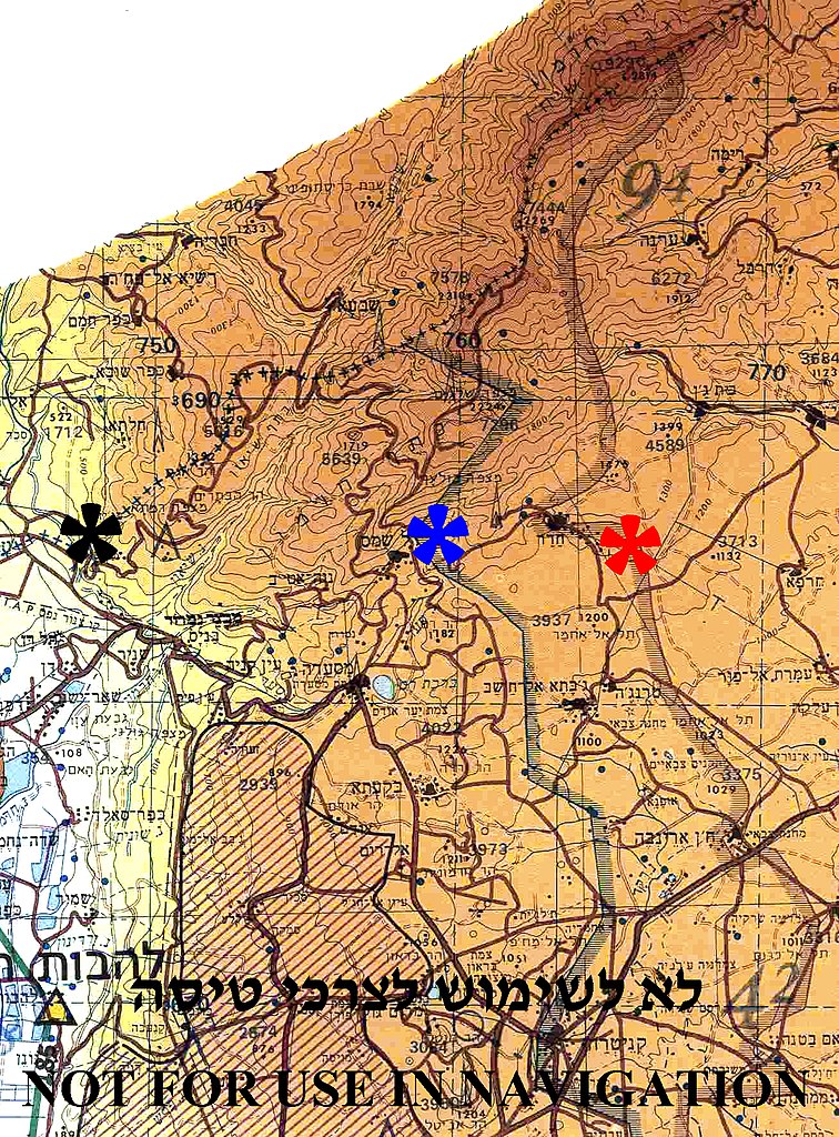
English: Borders between Israel, Syria and Lebanon in Mount Hermon region
The (+++) line between Israel and Lebanon – marked by black asterisk Disengagement Israeli front line with Syria (1974) - marked by blue asterisk Disengagement Syrian front line with Israel (1974) - marked by red asterisk. |
||
| ရက်စွဲ | |||
| ရင်းမြစ် | Aeronautical Information Publication - Domestic (AIP) of the Israel Civil Aviation Administration – presently Civil Aviation Authority (CAA) | ||
| စာရေးသူ | Etan Tal | ||
| ခွင့်ပြုချက် (ဤဖိုင်ကို ပြန်လည်အသုံးပြုခြင်း) |
|
Image to be used for illustration of aviation articles. Not for actual navigation. Original image is public domain (State Regulations) - uploader added the disclaimers prohibiting navigation use in compliance with normal aviation practice. Modified image released to the public domain as well.
ဖိုင်မှတ်တမ်း
ဖိုင်ကို ယင်းနေ့စွဲ အတိုင်း မြင်နိုင်ရန် နေ့စွဲ/အချိန် တစ်ခုခုပေါ်တွင် ကလစ်နှိပ်ပါ။
| နေ့စွဲ/အချိန် | နမူနာပုံငယ် | မှတ်တမ်း ဒိုင်မန်းရှင်းများ | အသုံးပြုသူ | မှတ်ချက် | |
|---|---|---|---|---|---|
| ကာလပေါ် | ၀၁:၀၈၊ ၁၂ အောက်တိုဘာ ၂၀၀၉ | | ၁၃၀၈ × ၁၇၇၂ (၂.၀၁ MB) | Etan J. Tal | {{Information |Description={{en|1=Borders between Israel, Syria and Lebanon in Mount Hermon region The Blue Line between Israel and Lebanon – marked by black asterisk Disengagement Israeli front line with Syria (1974) - marked by blue asterisk Disen |
ဖိုင်သုံးစွဲမှု
ဤဖိုင်ကို အသုံးပြုထားသော စာမျက်နှာများမရှိပါ။
ဂလိုဘယ် ဖိုင်သုံးစွဲမှု
အောက်ပါ အခြားဝီကီများတွင် ဤဖိုင်ကို အသုံးပြုထားသည်-
- ar.wikipedia.org တွင် အသုံးပြုမှု
- arz.wikipedia.org တွင် အသုံးပြုမှု
- ca.wikipedia.org တွင် အသုံးပြုမှု
- en.wikipedia.org တွင် အသုံးပြုမှု
- he.wikipedia.org တွင် အသုံးပြုမှု
- tt.wikipedia.org တွင် အသုံးပြုမှု