
ဖိုင်:Iberia 300BC-en.svg

Size of this PNG preview of this SVG file: ၇၂၇ × ၆၀၀ ပစ်ဇယ်. အခြား ပုံရိပ်ပြတ်သားမှု: ၂၉၁ × ၂၄၀ ပစ်ဇယ် | ၅၈၂ × ၄၈၀ ပစ်ဇယ် | ၉၃၁ × ၇၆၈ ပစ်ဇယ် | ၁၂၄၂ × ၁၀၂၄ ပစ်ဇယ် | ၂၄၈၄ × ၂၀၄၈ ပစ်ဇယ် | ၉၂၄ × ၇၆၂ ပစ်ဇယ်။
မူရင်းဖိုင် (SVG ဖိုင်, ၉၂၄ × ၇၆၂ pixels ကို အကြံပြုသည်, ဖိုင်အရွယ်အစား - ၇၇၂ KB)
| ဤဖိုင်သည် Wikimedia Commons မှဖြစ်ပြီး အခြားပရောဂျက်များတွင် သုံးကောင်းသုံးလိမ့်မည်။ ယင်း၏ ဖိုင်အကြောင်းစာမျက်နှာ တွင် ဖော်ပြထားချက်ကို အောက်တွင် ပြထားသည်။ Commons သည် မူပိုင်ခွင့်လွတ်လပ်သော မီဒီယာဖိုင်များ သိုလှောင်ထားရာ နေရာ ဖြစ်သည်။ သင်လည်း ပါဝင်ကူညီနိုင်ပါသည်။ |
အကျဉ်းချုပ်

|
This SVG file contains embedded text that can be translated into your language, using any capable SVG editor, text editor or the SVG Translate tool. For more information see: About translating SVG files. |
| ဖော်ပြချက် |
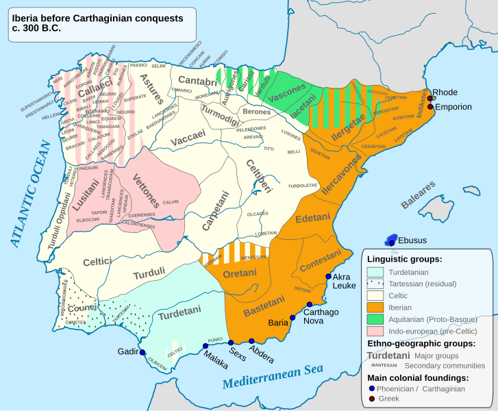
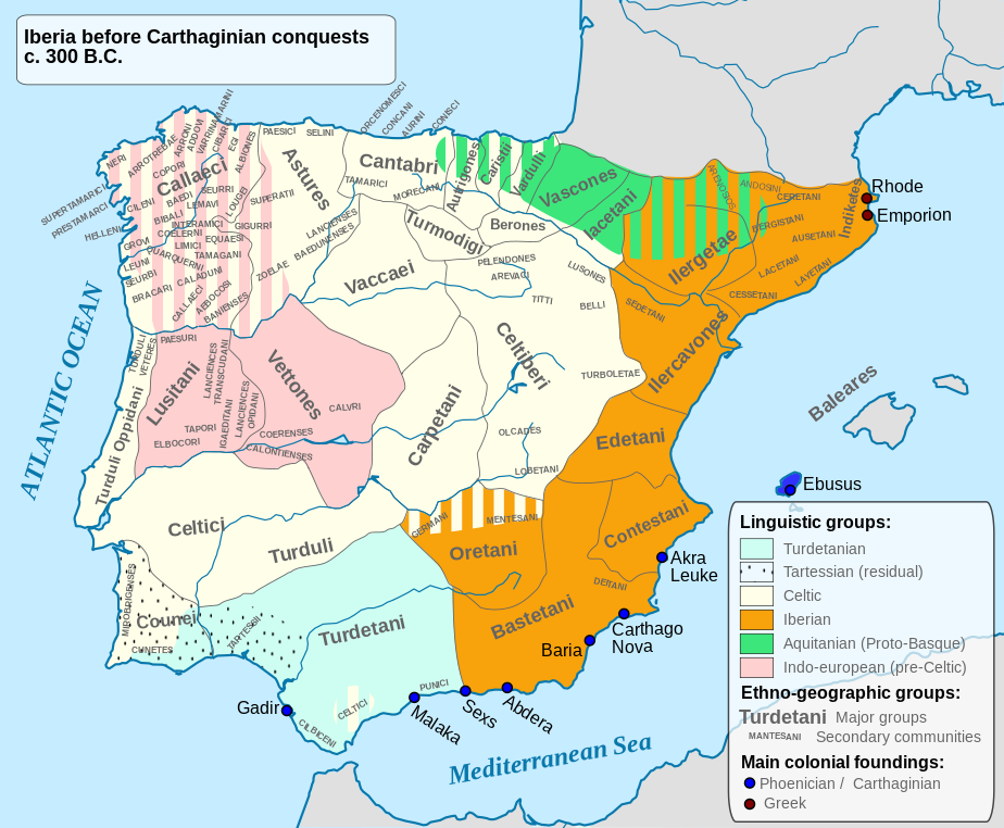
English: Ethnographic and Linguistic Map of the Iberian Peninsula at about 300 BCE (before the Carthaginian conquests). |
||
| ရက်စွဲ | |||
| ရင်းမြစ် |
Based on the map done by Portuguese Archeologist Luís Fraga, from the "Campo Arqueológico de Tavira". The reference map can be found at this location [1]. Original source: https://web.archive.org/web/20161105032508/http://geohistorica.net/arkeotavira.com/Mapas/Iberia/Populi.pdf |
||
| စာရေးသူ | Alcides Pinto | ||
| ခွင့်ပြုချက် (ဤဖိုင်ကို ပြန်လည်အသုံးပြုခြင်း) |
ကျွန်ုပ်၊ ဤလုပ်ဆောင်ချက်၏ မူပိုင်ခွင့်ပိုင်ရှင်အနေဖြင့် ဤနေရာမှ အောက်ပါလိုင်စင်အောက်တွင် ထုတ်လွှင့်ပါသည်:
|
||
| အခြား ဗားရှင်းများ |
Derivative works of this file: Ethnographic Iberia 200 BCE.PNG Languages of pre-Roman Iberia.jpg |

ဖိုင်မှတ်တမ်း
ဖိုင်ကို ယင်းနေ့စွဲ အတိုင်း မြင်နိုင်ရန် နေ့စွဲ/အချိန် တစ်ခုခုပေါ်တွင် ကလစ်နှိပ်ပါ။
| နေ့စွဲ/အချိန် | နမူနာပုံငယ် | မှတ်တမ်း ဒိုင်မန်းရှင်းများ | အသုံးပြုသူ | မှတ်ချက် | |
|---|---|---|---|---|---|
| ကာလပေါ် | ၁၅:၄၁၊ ၂၇ အောက်တိုဘာ ၂၀၂၃ | | ၉၂၄ × ၇၆၂ (၇၇၂ KB) | Il Qathar | Reverted to version as of 20:39, 10 August 2012 (UTC) (the most recent upload messed the captions, which are gone). |
| ၂၀:၂၅၊ ၇ ဇွန် ၂၀၂၂ |  | ၉၂၄ × ၇၆၂ (၇၁၁ KB) | Coralma* | File uploaded using svgtranslate tool (https://svgtranslate.toolforge.org/). Added translation for nl-informal. | |
| ၂၀:၃၉၊ ၁၀ ဩဂုတ် ၂၀၁၂ |  | ၉၂၄ × ၇၆၂ (၇၇၂ KB) | Galazan | More precise localization of: Indiketes, Ausetani, Layetani, Ilergetae, Ceretani and Andosini | |
| ၁၅:၄၅၊ ၈ ဧပြီ ၂၀၁၂ |  | ၉၂၄ × ၇၆၂ (၈၀၅ KB) | Kordas | Fixing Formentera color and showing mixed area in Oretania | |
| ၀၃:၄၂၊ ၈ ဧပြီ ၂၀၁၂ |  | ၉၂၄ × ၇၆၂ (၄၉၀ KB) | Kordas | See file talk | |
| ၂၃:၀၃၊ ၂၆ ဧပြီ ၂၀၁၀ |  | ၉၂၄ × ၇၆၂ (၃၂၆ KB) | Alcides Pinto | Solve upload problem | |
| ၂၂:၅၄၊ ၂၆ ဧပြီ ၂၀၁၀ |  | ၉၂၄ × ၇၆၂ (၃၂၆ KB) | Alcides Pinto | {{Information |Description={{en|1=Ethnographic and Linguistic Map of the Iberian Peninsula at about 300 BCE (before the Carthaginian conquests).}} |Source=Based on the map done by Portuguese Archeologist Luís Fraga, from the "Campo Arqueológico de Tavir |
ဖိုင်သုံးစွဲမှု
ဤဖိုင်ကို အသုံးပြုထားသော စာမျက်နှာများမရှိပါ။
ဂလိုဘယ် ဖိုင်သုံးစွဲမှု
အောက်ပါ အခြားဝီကီများတွင် ဤဖိုင်ကို အသုံးပြုထားသည်-
- ace.wikipedia.org တွင် အသုံးပြုမှု
- an.wikipedia.org တွင် အသုံးပြုမှု
- ast.wikipedia.org တွင် အသုံးပြုမှု
- be.wikipedia.org တွင် အသုံးပြုမှု
- bg.wikipedia.org တွင် အသုံးပြုမှု
- br.wikipedia.org တွင် အသုံးပြုမှု
- ca.wikipedia.org တွင် အသုံးပြုမှု
- da.wikipedia.org တွင် အသုံးပြုမှု
- de.wikipedia.org တွင် အသုံးပြုမှု
- Eisenzeit
- Spanische Sprache
- Baskische Sprache
- Iberer
- Keltiberer
- 194 v. Chr.
- Lusitaner
- Geschichte Karthagos
- Keltiberische Sprache
- Keltische Nationen
- Sprachen auf der Iberischen Halbinsel
- Kantabrer
- Benutzer Diskussion:Roxanna/Arbeitsplatz
- Liste antiker Ethnien der Iberischen Halbinsel
- Vettonen
- Turdetaner
- Carpetani
- Edetani
- Benutzer:JEW/Nekropole von El Cascarujo
- el.wikipedia.org တွင် အသုံးပြုမှု
- en.wikipedia.org တွင် အသုံးပြုမှု
ဤဖိုင်ကို အခြားနေရာများတွင် အသုံးပြုထားမှုများအား ကြည့်ရှုရန်။