
ဖိုင်:Ganymede - PIA02278.jpg
ဤနမူနာ၏ အရွယ်အစား - ၆၀၀ × ၆၀၀ ပစ်ဇယ်။ အခြား ပုံရိပ်ပြတ်သားမှု: ၂၄၀ × ၂၄၀ ပစ်ဇယ် | ၄၈၀ × ၄၈၀ ပစ်ဇယ် | ၇၉၆ × ၇၉၆ ပစ်ဇယ်။
မူရင်းဖိုင် (၇၉၆ × ၇၉၆ pixels, ဖိုင်အရွယ်အစား - ၂၄၇ KB, MIME အမျိုးအစား image/jpeg)
| ဤဖိုင်သည် Wikimedia Commons မှဖြစ်ပြီး အခြားပရောဂျက်များတွင် သုံးကောင်းသုံးလိမ့်မည်။ ယင်း၏ ဖိုင်အကြောင်းစာမျက်နှာ တွင် ဖော်ပြထားချက်ကို အောက်တွင် ပြထားသည်။ Commons သည် မူပိုင်ခွင့်လွတ်လပ်သော မီဒီယာဖိုင်များ သိုလှောင်ထားရာ နေရာ ဖြစ်သည်။ သင်လည်း ပါဝင်ကူညီနိုင်ပါသည်။ |
အကျဉ်းချုပ်
| ဖော်ပြချက် |
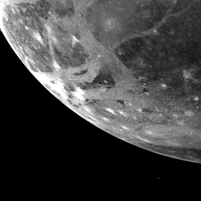
English: This picture of Ganymede, Jupiter's largest satellite, was taken by Voyager 1 on the afternoon of March 5, 1979 from a range of 253,000 kilometers (151,800 miles). The picture is centered at 66 south latitude and 3 longitude and shows the south western limb region of Ganymede. The smallest features visible are about 2.5 kilometers (1.5 miles) across. The surface shows numerous impact craters, many of which have extensive bright ray systems. Light bands traversing the surface contain alternating bright and dark lines which probably represent deformation of the icy central material. JPL manages and controls the Voyager Project for NASA's Office of Space Science. |
| ရက်စွဲ | |
| ရင်းမြစ် | http://photojournal.jpl.nasa.gov/catalog/PIA02278 |
| စာရေးသူ | NASA/JPL |
လိုင်စင်သတ်မှတ်ခြင်း
| This file is in the public domain in the United States because it was solely created by NASA. NASA copyright policy states that "NASA material is not protected by copyright unless noted". (See Template:PD-USGov, NASA copyright policy page or JPL Image Use Policy.) | ||
 |
Warnings:
|
ဖိုင်မှတ်တမ်း
ဖိုင်ကို ယင်းနေ့စွဲ အတိုင်း မြင်နိုင်ရန် နေ့စွဲ/အချိန် တစ်ခုခုပေါ်တွင် ကလစ်နှိပ်ပါ။
| နေ့စွဲ/အချိန် | နမူနာပုံငယ် | မှတ်တမ်း ဒိုင်မန်းရှင်းများ | အသုံးပြုသူ | မှတ်ချက် | |
|---|---|---|---|---|---|
| ကာလပေါ် | ၀၉:၄၉၊ ၄ ဇန်နဝါရီ ၂၀၁၉ | | ၇၉၆ × ၇၉၆ (၂၄၇ KB) | Kesäperuna | 100% JPEG quality from full quality TIFF. |
| ၂၂:၀၆၊ ၁၄ ဒီဇင်ဘာ ၂၀၁၀ |  | ၇၉၆ × ၇၉၆ (၇၀ KB) | Xession | {{Information |Description={{en|1=This picture of Ganymede, Jupiter's largest satellite, was taken by Voyager 1 on the afternoon of March 5, 1979 from a range of 253,000 kilometers (151,800 miles). The picture is centered at 66 south latitude and 3 longit |
ဖိုင်သုံးစွဲမှု
အောက်ပါ စာမျက်နှာ သည် ဤဖိုင်ကို အသုံးပြုထားသည်:
ဂလိုဘယ် ဖိုင်သုံးစွဲမှု
အောက်ပါ အခြားဝီကီများတွင် ဤဖိုင်ကို အသုံးပြုထားသည်-
- ar.wikipedia.org တွင် အသုံးပြုမှု
- ca.wikipedia.org တွင် အသုံးပြုမှု
- en.wikipedia.org တွင် အသုံးပြုမှု
- lmo.wikipedia.org တွင် အသုံးပြုမှု
- ms.wikipedia.org တွင် အသုံးပြုမှု
- oc.wikipedia.org တွင် အသုံးပြုမှု
- pt.wikipedia.org တွင် အသုံးပြုမှု
- ro.wikipedia.org တွင် အသုံးပြုမှု
- ta.wikipedia.org တွင် အသုံးပြုမှု
- th.wikipedia.org တွင် အသုံးပြုမှု
- vi.wikipedia.org တွင် အသုံးပြုမှု
- zh-yue.wikipedia.org တွင် အသုံးပြုမှု
- zh.wikipedia.org တွင် အသုံးပြုမှု