
ဖိုင်:French Empire on World 1812.png
ဤနမူနာ၏ အရွယ်အစား - ၈၀၀ × ၃၇၀ ပစ်ဇယ်။ အခြား ပုံရိပ်ပြတ်သားမှု: ၃၂၀ × ၁၄၈ ပစ်ဇယ် | ၆၄၀ × ၂၉၆ ပစ်ဇယ် | ၁၃၅၇ × ၆၂၈ ပစ်ဇယ်။
မူရင်းဖိုင် (၁၃၅၇ × ၆၂၈ pixels, ဖိုင်အရွယ်အစား - ၁၅ KB, MIME အမျိုးအစား image/png)
| ဤဖိုင်သည် Wikimedia Commons မှဖြစ်ပြီး အခြားပရောဂျက်များတွင် သုံးကောင်းသုံးလိမ့်မည်။ ယင်း၏ ဖိုင်အကြောင်းစာမျက်နှာ တွင် ဖော်ပြထားချက်ကို အောက်တွင် ပြထားသည်။ Commons သည် မူပိုင်ခွင့်လွတ်လပ်သော မီဒီယာဖိုင်များ သိုလှောင်ထားရာ နေရာ ဖြစ်သည်။ သင်လည်း ပါဝင်ကူညီနိုင်ပါသည်။ |
အကျဉ်းချုပ်
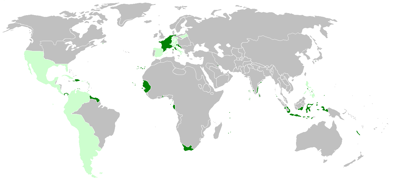
| ဖော်ပြချက် | First French Empire before the french invasion of Russia on World 1812, with annexed or occupied colonies, satellite states, allied states and dependent colonies. | ||
| ရက်စွဲ | |||
| ရင်းမြစ် | http://de.wikipedia.org/wiki/Erstes_Kaiserreich, napoleonská Francie a Evropa 1812 | ||
| စာရေးသူ | Hruska | ||
| အခြား ဗားရှင်းများ |
|

လိုင်စင်သတ်မှတ်ခြင်း
ကျွန်ုပ်၊ ဤလုပ်ဆောင်ချက်၏ မူပိုင်ခွင့်ပိုင်ရှင်အနေဖြင့် ဤနေရာမှ အောက်ပါလိုင်စင်အောက်တွင် ထုတ်လွှင့်ပါသည်:
ဤဖိုင်ကို Creative Commons Attribution-Share Alike 3.0 Unported လိုင်စင်ဖြင့် သတ်မှတ်ထားသည်။
- သင်သည် လွတ်လပ်စွာ:
- မျှဝေရန် – ဖန်တီးမှုကို ကူးယူရန်၊ ဖြန့်ဖြူးရန်နှင့် ထုတ်လွှင့်ရန်
- ပြန်ရောနှောရန် – ဖန်တီးမှုကို ပြင်ဆင်ညှိနှိုင်းရန်
- အောက်ပါ အခြေအနေများတွင်:
- မှတ်ယူနိုင်ခြင်း – ပြောင်းလဲမှုများ ပြုလုပ်ခဲ့ပါက ဖန်တီးသူ သို့မဟုတ် လိုင်စင်ရှိသူမှ သတ်မှတ်သော အမျိုးအစားကို လိုက်နာရမည် (ဆိုလိုသည်မှာ သင့်အား သို့မဟုတ် သင့်ဖန်တီးမှုတွင် အသုံးပြုခြင်းအား ထောက်ခံချက်ပေးသည်ဟု မဆိုလိုပါ)။
- ထပ်တူမျှဝေ – ဤဖန်တီးမှုအား ပြင်ဆင်ခြင်း၊ ပြောင်းလဲခြင်း သို့မဟုတ် ထပ်ဆင့် ဖန်တီးခြင်း ပြုလုပ်ပါက ရရှိလာသော ဖန်တီးမှုကို ဤဖန်တီးမှုနှင့် သို့မဟုတ် ဆင်တူသော လိုင်စင်ဖြင့်သာ ဖြန့်ချိသင့်သည်။
ဖိုင်မှတ်တမ်း
ဖိုင်ကို ယင်းနေ့စွဲ အတိုင်း မြင်နိုင်ရန် နေ့စွဲ/အချိန် တစ်ခုခုပေါ်တွင် ကလစ်နှိပ်ပါ။
| နေ့စွဲ/အချိန် | နမူနာပုံငယ် | မှတ်တမ်း ဒိုင်မန်းရှင်းများ | အသုံးပြုသူ | မှတ်ချက် | |
|---|---|---|---|---|---|
| ကာလပေါ် | ၂၃:၅၁၊ ၁၇ မတ် ၂၀၂၂ | | ၁၃၅၇ × ၆၂၈ (၁၅ KB) | M.Bitton | per [https://commons.wikimedia.org/w/index.php?title=Commons:Graphic_Lab/Map_workshop&oldid=640501111#Wrong_borders] |
| ၂၁:၀၈၊ ၂၅ ဧပြီ ၂၀၂၁ |  | ၁၃၅၇ × ၆၂၈ (၃၃ KB) | M.Bitton | Reverted to version as of 15:19, 6 December 2014 (UTC): If you don't want to be reported to the admins, I suggest you stop edit warring and read COM:OVERWRITE | |
| ၁၄:၅၈၊ ၂၅ ဧပြီ ၂၀၂၁ |  | ၁၃၅၇ × ၆၂၈ (၃၀ KB) | محمد٢ | Morocco wasn't a Spanish satellite state | |
| ၂၂:၀၄၊ ၁၅ ဧပြီ ၂၀၂၁ |  | ၁၃၅၇ × ၆၂၈ (၃၃ KB) | M.Bitton | Reverted to version as of 15:19, 6 December 2014 (UTC): per COM:OVERWRITE | |
| ၂၁:၃၇၊ ၁၄ ဧပြီ ၂၀၂၁ |  | ၁၃၅၇ × ၆၂၈ (၃၀ KB) | محمد٢ | Reverted to version as of 20:17, 14 April 2021 (UTC) | |
| ၂၀:၂၃၊ ၁၄ ဧပြီ ၂၀၂၁ |  | ၁၃၅၇ × ၆၂၈ (၃၀ KB) | محمد٢ | Reverted to version as of 18:02, 14 April 2021 (UTC) | |
| ၂၀:၁၇၊ ၁၄ ဧပြီ ၂၀၂၁ |  | ၁၃၅၇ × ၆၂၈ (၃၀ KB) | محمد٢ | border | |
| ၁၈:၀၂၊ ၁၄ ဧပြီ ၂၀၂၁ |  | ၁၃၅၇ × ၆၂၈ (၃၀ KB) | محمد٢ | border | |
| ၁၅:၁၉၊ ၆ ဒီဇင်ဘာ ၂၀၁၄ |  | ၁၃၅၇ × ၆၂၈ (၃၃ KB) | Hruska~commonswiki | broder | |
| ၀၉:၅၈၊ ၆ ဒီဇင်ဘာ ၂၀၁၄ |  | ၁၃၅၇ × ၆၂၈ (၃၃ KB) | Hruska~commonswiki | island |
ဖိုင်သုံးစွဲမှု
ဤဖိုင်ကို အသုံးပြုထားသော စာမျက်နှာများမရှိပါ။
ဂလိုဘယ် ဖိုင်သုံးစွဲမှု
အောက်ပါ အခြားဝီကီများတွင် ဤဖိုင်ကို အသုံးပြုထားသည်-
- ar.wikipedia.org တွင် အသုံးပြုမှု
- ast.wikipedia.org တွင် အသုံးပြုမှု
- be.wikipedia.org တွင် အသုံးပြုမှု
- br.wikipedia.org တွင် အသုံးပြုမှု
- de.wikipedia.org တွင် အသုံးပြုမှု
- el.wikipedia.org တွင် အသုံးပြုမှု
- en.wikipedia.org တွင် အသုံးပြုမှု
- es.wikipedia.org တွင် အသုံးပြုမှု
- eu.wikipedia.org တွင် အသုံးပြုမှု
- fa.wikipedia.org တွင် အသုံးပြုမှု
- fr.wikipedia.org တွင် အသုံးပြုမှု
- hr.wikipedia.org တွင် အသုံးပြုမှု
- id.wikipedia.org တွင် အသုံးပြုမှု
- it.wikipedia.org တွင် အသုံးပြုမှု
- ja.wikipedia.org တွင် အသုံးပြုမှု
- kk.wikipedia.org တွင် အသုံးပြုမှု
- lt.wikipedia.org တွင် အသုံးပြုမှု
- mn.wikipedia.org တွင် အသုံးပြုမှု
- ms.wikipedia.org တွင် အသုံးပြုမှု
- mt.wikipedia.org တွင် အသုံးပြုမှု
- rm.wikipedia.org တွင် အသုံးပြုမှု
- th.wikipedia.org တွင် အသုံးပြုမှု
- uk.wikipedia.org တွင် အသုံးပြုမှု
- vi.wikipedia.org တွင် အသုံးပြုမှု
- www.wikidata.org တွင် အသုံးပြုမှု
- zh.wikipedia.org တွင် အသုံးပြုမှု