
ဖိုင်:France autoroutes map-fr.svg

Size of this PNG preview of this SVG file: ၆၂၄ × ၆၀၀ ပစ်ဇယ်. အခြား ပုံရိပ်ပြတ်သားမှု: ၂၅၀ × ၂၄၀ ပစ်ဇယ် | ၄၉၉ × ၄၈၀ ပစ်ဇယ် | ၇၉၉ × ၇၆၈ ပစ်ဇယ် | ၁၀၆၆ × ၁၀၂၄ ပစ်ဇယ် | ၂၁၃၁ × ၂၀၄၈ ပစ်ဇယ် | ၂၀၀၀ × ၁၉၂၂ ပစ်ဇယ်။
မူရင်းဖိုင် (SVG ဖိုင်, ၂၀၀၀ × ၁၉၂၂ pixels ကို အကြံပြုသည်, ဖိုင်အရွယ်အစား - ၄.၆၂ MB)
| ဤဖိုင်သည် Wikimedia Commons မှဖြစ်ပြီး အခြားပရောဂျက်များတွင် သုံးကောင်းသုံးလိမ့်မည်။ ယင်း၏ ဖိုင်အကြောင်းစာမျက်နှာ တွင် ဖော်ပြထားချက်ကို အောက်တွင် ပြထားသည်။ Commons သည် မူပိုင်ခွင့်လွတ်လပ်သော မီဒီယာဖိုင်များ သိုလှောင်ထားရာ နေရာ ဖြစ်သည်။ သင်လည်း ပါဝင်ကူညီနိုင်ပါသည်။ |
အကျဉ်းချုပ်
| ဖော်ပြချက် |
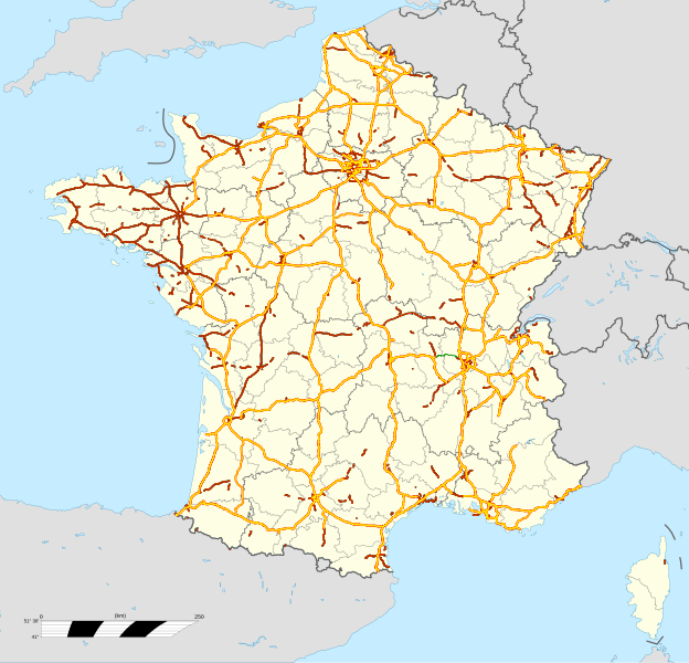
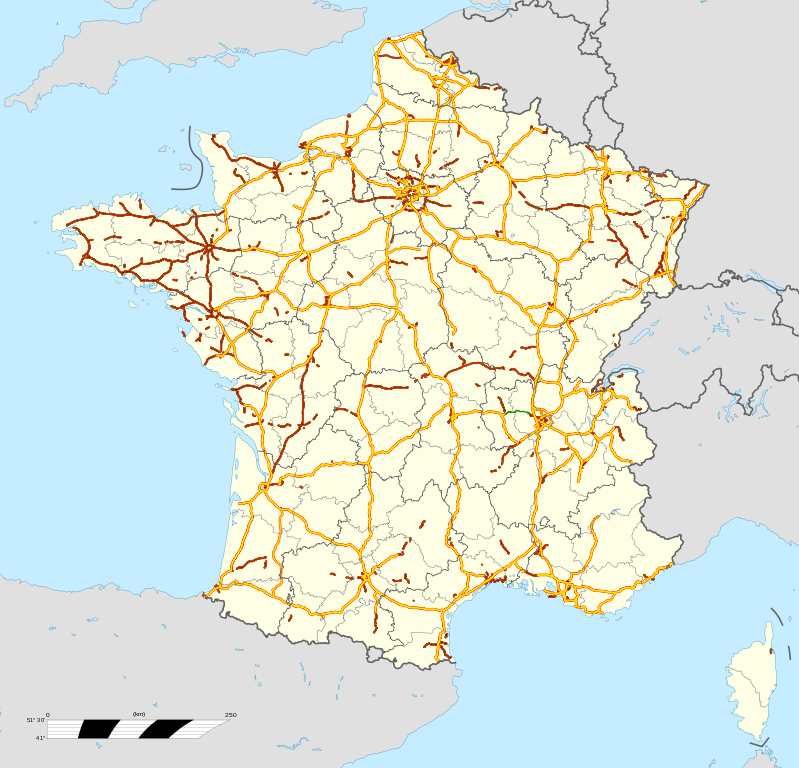
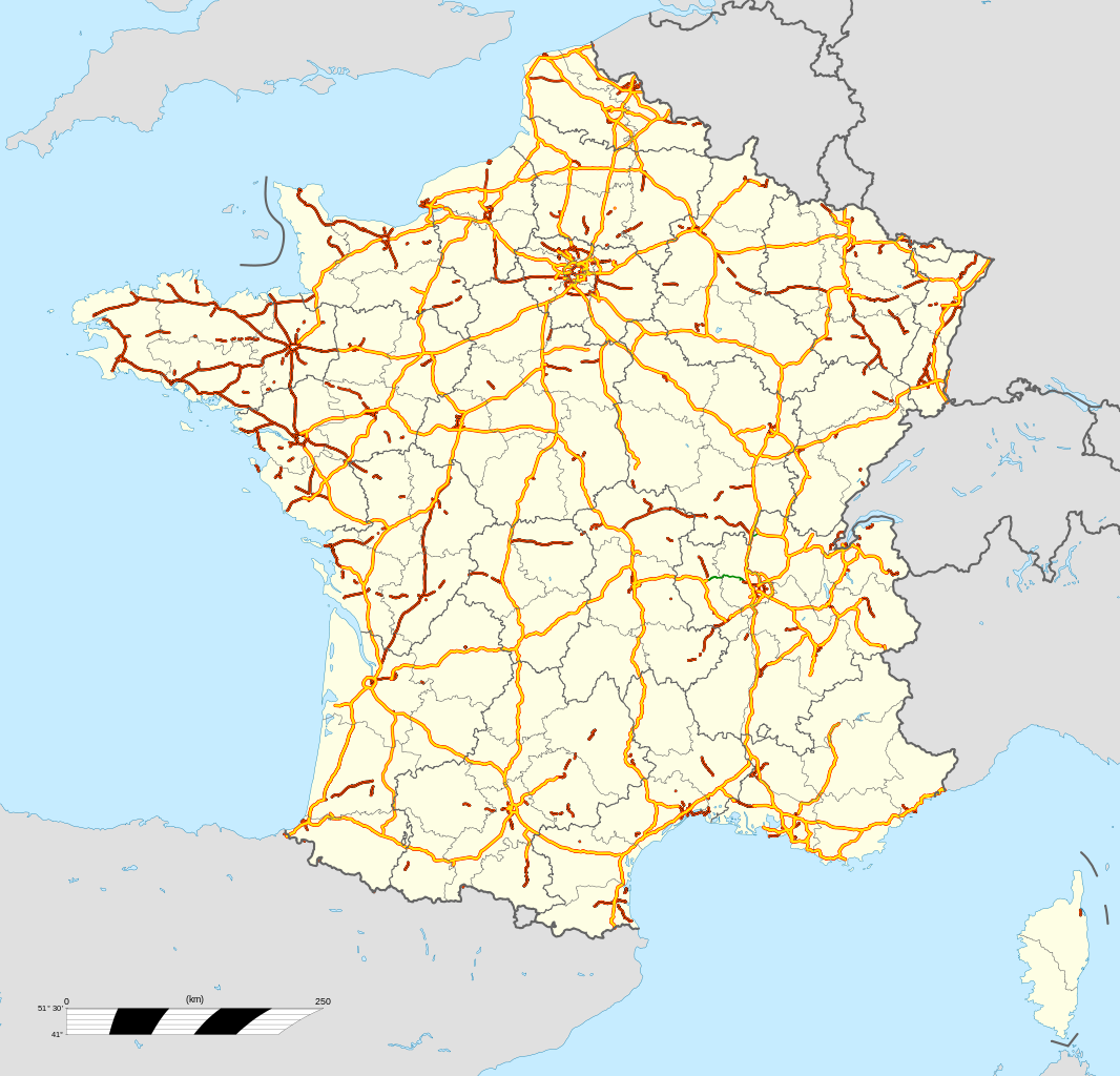
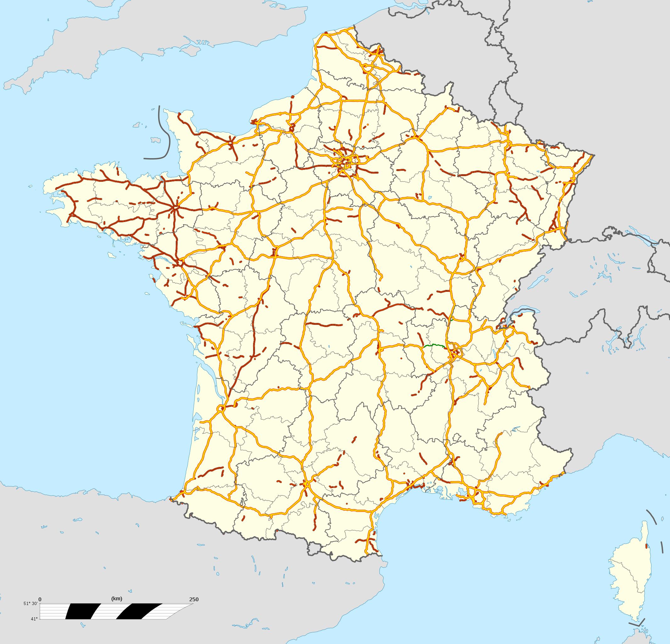
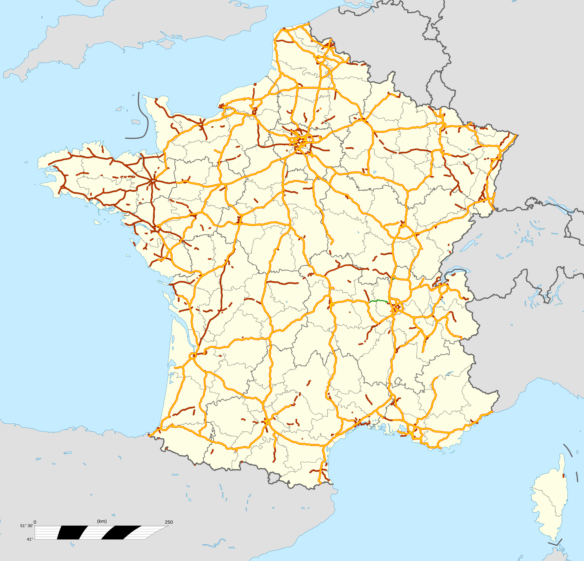
English: Map of motorways of France, with regions and departements distinguished.
Approximate scale : 1:3,000,000 Français : Carte du réseau autoroutier de la France, avec régions et départements distingués.
Échelle approximative : 1:3 000 000 Equirectangular projection, WGS84 datum
Geographic limits of the map :
|
| ရက်စွဲ | |
| ရင်းမြစ် |
ကိုယ်ပိုင်ဖန်တီးမှု
|
| စာရေးသူ | Bourrichon (motorways) ; fond de carte / bottom map : File:France location map-Regions and departements.svg by Sting - fr:Sting |
.svg)
| Object location | | View this and other nearby images on: OpenStreetMap |
|---|
လိုင်စင်သတ်မှတ်ခြင်း
ကျွန်ုပ်၊ ဤလုပ်ဆောင်ချက်၏ မူပိုင်ခွင့်ပိုင်ရှင်အနေဖြင့် ဤနေရာမှ အောက်ပါလိုင်စင်များအောက်တွင် ထုတ်လွှင့်ပါသည်:

|
ဤစာတမ်းကို GNU Free Documentation License, ဗားရှင်း ၁.၂ သို့မဟုတ် Free Software Foundation မှ ဖြန့်ချီထားသော မည်သည့်ယခင်ဗားရှင်းတစ်ခုခုအောက်တွင် Invariant Sections, Front-Cover Texts နှင့် Back-Cover Texts များမပါဝင်ဘဲ ကူးယူခြင်း၊ ဖြန့်ချီခြင်း နှင့်/သို့မဟုတ် ပြင်ဆင်ပြောင်းလဲနိုင်ရန် ခွင့်ပြုသည်။ လိုင်စင်မူပွားကို GNU Free Documentation License ခေါင်းစဉ်အောက်တွင် ထည့်သွင်းထားသည်။ |
This file is licensed under the Creative Commons Attribution-Share Alike Attribution-Share Alike 4.0 International, 3.0 Unported, 2.5 Generic, 2.0 Generic and 1.0 Generic license.
- သင်သည် လွတ်လပ်စွာ:
- မျှဝေရန် – ဖန်တီးမှုကို ကူးယူရန်၊ ဖြန့်ဖြူးရန်နှင့် ထုတ်လွှင့်ရန်
- ပြန်ရောနှောရန် – ဖန်တီးမှုကို ပြင်ဆင်ညှိနှိုင်းရန်
- အောက်ပါ အခြေအနေများတွင်:
- မှတ်ယူနိုင်ခြင်း – ပြောင်းလဲမှုများ ပြုလုပ်ခဲ့ပါက ဖန်တီးသူ သို့မဟုတ် လိုင်စင်ရှိသူမှ သတ်မှတ်သော အမျိုးအစားကို လိုက်နာရမည် (ဆိုလိုသည်မှာ သင့်အား သို့မဟုတ် သင့်ဖန်တီးမှုတွင် အသုံးပြုခြင်းအား ထောက်ခံချက်ပေးသည်ဟု မဆိုလိုပါ)။
- ထပ်တူမျှဝေ – ဤဖန်တီးမှုအား ပြင်ဆင်ခြင်း၊ ပြောင်းလဲခြင်း သို့မဟုတ် ထပ်ဆင့် ဖန်တီးခြင်း ပြုလုပ်ပါက ရရှိလာသော ဖန်တီးမှုကို ဤဖန်တီးမှုနှင့် သို့မဟုတ် ဆင်တူသော လိုင်စင်ဖြင့်သာ ဖြန့်ချိသင့်သည်။
သင်အလိုရှိရာ လိုင်စင်ကို ရွေးချယ်နိုင်ပါသည်။
လိုင်စင်သတ်မှတ်ခြင်း
ကျွန်ုပ်၊ ဤလုပ်ဆောင်ချက်၏ မူပိုင်ခွင့်ပိုင်ရှင်အနေဖြင့် ဤနေရာမှ အောက်ပါလိုင်စင်အောက်တွင် ထုတ်လွှင့်ပါသည်:
ဤဖိုင်သည် Creative Commons Attribution 3.0 Unported လိုင်စင်အောက်တွင် လိုင်စင်သတ်မှတ်ထားပါသည်။
- သင်သည် လွတ်လပ်စွာ:
- မျှဝေရန် – ဖန်တီးမှုကို ကူးယူရန်၊ ဖြန့်ဖြူးရန်နှင့် ထုတ်လွှင့်ရန်
- ပြန်ရောနှောရန် – ဖန်တီးမှုကို ပြင်ဆင်ညှိနှိုင်းရန်
- အောက်ပါ အခြေအနေများတွင်:
- မှတ်ယူနိုင်ခြင်း – ပြောင်းလဲမှုများ ပြုလုပ်ခဲ့ပါက ဖန်တီးသူ သို့မဟုတ် လိုင်စင်ရှိသူမှ သတ်မှတ်သော အမျိုးအစားကို လိုက်နာရမည် (ဆိုလိုသည်မှာ သင့်အား သို့မဟုတ် သင့်ဖန်တီးမှုတွင် အသုံးပြုခြင်းအား ထောက်ခံချက်ပေးသည်ဟု မဆိုလိုပါ)။
ဖိုင်မှတ်တမ်း
ဖိုင်ကို ယင်းနေ့စွဲ အတိုင်း မြင်နိုင်ရန် နေ့စွဲ/အချိန် တစ်ခုခုပေါ်တွင် ကလစ်နှိပ်ပါ။
| နေ့စွဲ/အချိန် | နမူနာပုံငယ် | မှတ်တမ်း ဒိုင်မန်းရှင်းများ | အသုံးပြုသူ | မှတ်ချက် | |
|---|---|---|---|---|---|
| ကာလပေါ် | ၁၄:၀၂၊ ၁၆ မေ ၂၀၂၄ | | ၂၀၀၀ × ၁၉၂၂ (၄.၆၂ MB) | Jack ma | Updated regions limits |
| ၁၁:၁၇၊ ၃၁ ဇူလိုင် ၂၀၁၂ |  | ၂၀၀၀ × ၁၉၂၂ (၄.၆ MB) | Bourrichon | actualisation : A21, A432 nord, A75→A9 | |
| ၁၁:၁၅၊ ၃၁ ဇူလိုင် ၂၀၁၂ |  | ၂၀၀၀ × ၁၉၂၂ (၄.၆ MB) | Bourrichon | actualisation : A21, A432 nord, A75→A9 | |
| ၀၀:၃၉၊ ၁၂ မေ ၂၀၁၂ |  | ၂၀၀၀ × ၁၉၂၂ (၃.၄၇ MB) | Bourrichon | ||
| ၂၃:၅၂၊ ၁၁ မေ ၂၀၁၂ |  | ၂၀၀၀ × ၁၉၂၂ (၂.၃၉ MB) | Bourrichon | ||
| ၁၈:၀၆၊ ၁၀ မေ ၂၀၁၂ |  | ၂၀၀၀ × ၁၉၂၂ (၃.၆၄ MB) | Bourrichon | == {{int:filedesc}} == {{Information |Description={{en|Map of motorways of France, with regions and departements distinguished.<br/>Approximate scale : 1:3,000,000}} {{fr|Carte du réseau autoroutier... |
ဖိုင်သုံးစွဲမှု
ဤဖိုင်ကို အသုံးပြုထားသော စာမျက်နှာများမရှိပါ။
ဂလိုဘယ် ဖိုင်သုံးစွဲမှု
အောက်ပါ အခြားဝီကီများတွင် ဤဖိုင်ကို အသုံးပြုထားသည်-
- cs.wikipedia.org တွင် အသုံးပြုမှု
- de.wikipedia.org တွင် အသုံးပြုမှု
- el.wikipedia.org တွင် အသုံးပြုမှု
- en.wikipedia.org တွင် အသုံးပြုမှု
- es.wikipedia.org တွင် အသုံးပြုမှု
- es.wikivoyage.org တွင် အသုံးပြုမှု
- fr.wikipedia.org တွင် အသုံးပြုမှု
- fr.wikivoyage.org တွင် အသုံးပြုမှု
- fy.wikipedia.org တွင် အသုံးပြုမှု
- he.wikivoyage.org တွင် အသုံးပြုမှု
- it.wikipedia.org တွင် အသုံးပြုမှု
- no.wikipedia.org တွင် အသုံးပြုမှု
- pl.wikipedia.org တွင် အသုံးပြုမှု
- pt.wikipedia.org တွင် အသုံးပြုမှု
- ru.wikipedia.org တွင် အသုံးပြုမှု
- uk.wikipedia.org တွင် အသုံးပြုမှု
- Автомагістралі Франції
- Автомагістраль А1 (Франція)
- Автомагістраль А2 (Франція)
- Автомагістраль А3 (Франція)
- Автомагістраль А4 (Франція)
- Автомагістраль А5 (Франція)
- Автомагістраль А6 (Франція)
- Автомагістраль А7 (Франція)
- Автомагістраль А8 (Франція)
- Автомагістраль А9 (Франція)
- Автомагістраль А10 (Франція)
- Автомагістраль А11 (Франція)
- Автомагістраль А12 (Франція)
- Автомагістраль А13 (Франція)
- Автомагістраль А14 (Франція)
- Автомагістраль А15 (Франція)
- Автомагістраль А86 (Франція)
- Автомагістраль А16 (Франція)
- Автомагістраль А19 (Франція)
- Автомагістраль А20 (Франція)
- Автомагістраль А21 (Франція)
- Автомагістраль А22 (Франція)
- Автомагістраль А23 (Франція)
- Автомагістраль А25 (Франція)
ဤဖိုင်ကို အခြားနေရာများတွင် အသုံးပြုထားမှုများအား ကြည့်ရှုရန်။