
ဖိုင်:EmpireFrench.png

ဤနမူနာ၏ အရွယ်အစား - ၈၀၀ × ၄၀၇ ပစ်ဇယ်။ အခြား ပုံရိပ်ပြတ်သားမှု: ၃၂၀ × ၁၆၃ ပစ်ဇယ် | ၆၄၀ × ၃၂၅ ပစ်ဇယ် | ၁၀၂၄ × ၅၂၁ ပစ်ဇယ် | ၁၂၈၀ × ၆၅၁ ပစ်ဇယ် | ၂၇၅၃ × ၁၄၀၀ ပစ်ဇယ်။
မူရင်းဖိုင် (၂၇၅၃ × ၁၄၀၀ pixels, ဖိုင်အရွယ်အစား - ၁၉၃ KB, MIME အမျိုးအစား image/png)
| ဤဖိုင်သည် Wikimedia Commons မှဖြစ်ပြီး အခြားပရောဂျက်များတွင် သုံးကောင်းသုံးလိမ့်မည်။ ယင်း၏ ဖိုင်အကြောင်းစာမျက်နှာ တွင် ဖော်ပြထားချက်ကို အောက်တွင် ပြထားသည်။ Commons သည် မူပိုင်ခွင့်လွတ်လပ်သော မီဒီယာဖိုင်များ သိုလှောင်ထားရာ နေရာ ဖြစ်သည်။ သင်လည်း ပါဝင်ကူညီနိုင်ပါသည်။ |


|
This historical map image could be re-created using vector graphics as an SVG file. This has several advantages; see Commons:Media for cleanup for more information. If an SVG form of this image is available, please upload it and afterwards replace this template with
{{vector version available|new image name}}.
It is recommended to name the SVG file “EmpireFrench.svg”—then the template Vector version available (or Vva) does not need the new image name parameter. |
အကျဉ်းချုပ်
| ဖော်ပြချက် |
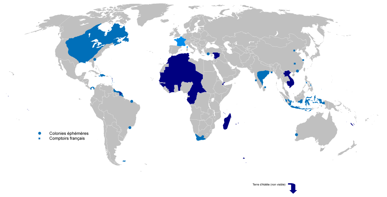
English: Colonial empire from 1542 to 1980
Dark Blue: Second colonial empire Light Blue: First colonial empire |
| ရက်စွဲ | 01/06/2010 |
| ရင်းမြစ် | ကိုယ်ပိုင်ဖန်တီးမှု |
| စာရေးသူ | Gd21091993 |
လိုင်စင်သတ်မှတ်ခြင်း
| I, the copyright holder of this work, release this work into the public domain. This applies worldwide. In some countries this may not be legally possible; if so: အကျွန်ုပ်သည် ဤဖန်တီးမှုလက်ရာကို ဥပဒေအရလိုအပ်ခြင်းမရှိသည့် မည်သည့်အခြေအနေမျိုးတွက်မဆို၊ မည်သို့သော ရည်ရွယ်ချက်အတွက်မဆို ၎င်းကို မည်သူမဆို အသုံးပြုပိုင်ခွင့်အား ပေးအပ်သည်။ |
ဖိုင်မှတ်တမ်း
ဖိုင်ကို ယင်းနေ့စွဲ အတိုင်း မြင်နိုင်ရန် နေ့စွဲ/အချိန် တစ်ခုခုပေါ်တွင် ကလစ်နှိပ်ပါ။
| နေ့စွဲ/အချိန် | နမူနာပုံငယ် | မှတ်တမ်း ဒိုင်မန်းရှင်းများ | အသုံးပြုသူ | မှတ်ချက် | |
|---|---|---|---|---|---|
| ကာလပေါ် | ၁၇:၀၂၊ ၄ ဧပြီ ၂၀၂၂ | | ၂၇၅၃ × ၁၄၀၀ (၁၉၃ KB) | Oort kuipert | added territory in india and america, source : https://commons.wikimedia.org/wiki/File:New_France_(orthographic_projection).svg https://commons.wikimedia.org/wiki/File:French_possessions_in_the_Americas_(1534-1803).png https://commons.wikimedia.org/wiki/File:Evolution_empire.png |
| ၁၅:၄၁၊ ၃၀ မတ် ၂၀၂၂ |  | ၂၇၅၃ × ၁၄၀၀ (၁၉၄ KB) | Oort kuipert | added colonies under Napoléon I according to https://upload.wikimedia.org/wikipedia/commons/3/33/French_Empire_on_World_1812.png | |
| ၁၂:၀၁၊ ၈ အောက်တိုဘာ ၂၀၁၇ |  | ၂၇၅၃ × ၁၄၀၀ (၁၁၆ KB) | SUM1 | Fixes: unshaded Spanish Morocco (Cape Juby), Equatorial Guinea, Nigeria, Southern Cameroons, Zanzibar, Czech border | |
| ၁၃:၄၆၊ ၂ မတ် ၂၀၁၆ |  | ၂၇၅၃ × ၁၄၀၀ (၉၉ KB) | Frans45 | in New Caledonia archipelago only the big island was marked, I added : îles Loayutés, île de Pins, îles Chesterfield | |
| ၁၅:၂၉၊ ၁ ဇွန် ၂၀၁၀ |  | ၂၇၅၃ × ၁၄၀၀ (၃၁၆ KB) | Gd21091993 | {{Information |Description={{fr|1=Carte de l'Empire Colonial Français de 1542 à 1980 }} |Source={{own}} |Author=Gd21091993 |Date=01/06/2010 |Permission= |other_versions= }} |
ဖိုင်သုံးစွဲမှု
ဤဖိုင်ကို အသုံးပြုထားသော စာမျက်နှာများမရှိပါ။
ဂလိုဘယ် ဖိုင်သုံးစွဲမှု
အောက်ပါ အခြားဝီကီများတွင် ဤဖိုင်ကို အသုံးပြုထားသည်-
- ar.wikipedia.org တွင် အသုံးပြုမှု
- ast.wikipedia.org တွင် အသုံးပြုမှု
- azb.wikipedia.org တွင် အသုံးပြုမှု
- bg.wikipedia.org တွင် အသုံးပြုမှု
- br.wikipedia.org တွင် အသုံးပြုမှု
- ca.wikipedia.org တွင် အသုံးပြုမှု
- cs.wikipedia.org တွင် အသုံးပြုမှု
- el.wikipedia.org တွင် အသုံးပြုမှု
- en.wikipedia.org တွင် အသုံးပြုမှု
- Empire
- User:Dimadick
- Kingdom of France
- French colonial flags
- Analysis of Western European colonialism and colonization
- Evolution of the French colonial empire
- Political history of the world
- User:Jethwarp
- Timeline of European imperialism
- List of modern great powers
- User:Jethwarp/UBX/French Colonial empire
- Category:Wikipedians interested in European colonial empires
- Liberation of France
- Honor killings by region
- en.wikibooks.org တွင် အသုံးပြုမှု
- en.wikiquote.org တွင် အသုံးပြုမှု
- en.wiktionary.org တွင် အသုံးပြုမှု
- eo.wikipedia.org တွင် အသုံးပြုမှု
- es.wikipedia.org တွင် အသုံးပြုမှု
- eu.wikipedia.org တွင် အသုံးပြုမှု
- fa.wikipedia.org တွင် အသုံးပြုမှု
- fi.wikipedia.org တွင် အသုံးပြုမှု
- fr.wikipedia.org တွင် အသုံးပြုမှု
- fr.wiktionary.org တွင် အသုံးပြုမှု
- gl.wikipedia.org တွင် အသုံးပြုမှု
ဤဖိုင်ကို အခြားနေရာများတွင် အသုံးပြုထားမှုများအား ကြည့်ရှုရန်။