
ဖိုင်:Earth cutaway schematic-en.svg

Size of this PNG preview of this SVG file: ၅၁၂ × ၃၃၄ ပစ်ဇယ်. အခြား ပုံရိပ်ပြတ်သားမှု: ၃၂၀ × ၂၀၉ ပစ်ဇယ် | ၆၄၀ × ၄၁၈ ပစ်ဇယ် | ၁၀၂၄ × ၆၆၈ ပစ်ဇယ် | ၁၂၈၀ × ၈၃၅ ပစ်ဇယ် | ၂၅၆၀ × ၁၆၇၀ ပစ်ဇယ်။
မူရင်းဖိုင် (SVG ဖိုင်, ၅၁၂ × ၃၃၄ pixels ကို အကြံပြုသည်, ဖိုင်အရွယ်အစား - ၆၇ KB)
| ဤဖိုင်သည် Wikimedia Commons မှဖြစ်ပြီး အခြားပရောဂျက်များတွင် သုံးကောင်းသုံးလိမ့်မည်။ ယင်း၏ ဖိုင်အကြောင်းစာမျက်နှာ တွင် ဖော်ပြထားချက်ကို အောက်တွင် ပြထားသည်။ Commons သည် မူပိုင်ခွင့်လွတ်လပ်သော မီဒီယာဖိုင်များ သိုလှောင်ထားရာ နေရာ ဖြစ်သည်။ သင်လည်း ပါဝင်ကူညီနိုင်ပါသည်။ |
အကျဉ်းချုပ်
| ဖော်ပြချက် |
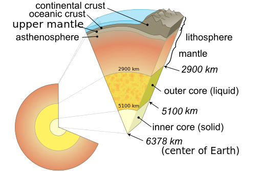
English: Cutaway diagram of Earth's internal structure (to scale) with inset showing detailed breakdown of structure (not to scale) |
| ရက်စွဲ | (UTC) |
| ရင်းမြစ် |
|
| စာရေးသူ |
|
| အခြား ဗားရှင်းများ |
[]
PNG:
|


.svg)
-fr.svg)


| This is a retouched picture, which means that it has been digitally altered from its original version. Modifications: Vectored. The original can be viewed here: Earth cutaway schematic-en.png:
|
This vector image was created with Inkscape by Anasofiapaixao, and then manually expanded by Anasofiapaixao
.ကျွန်ုပ်၊ ဤလုပ်ဆောင်ချက်၏ မူပိုင်ခွင့်ပိုင်ရှင်အနေဖြင့် ဤနေရာမှ အောက်ပါလိုင်စင်အောက်တွင် ထုတ်လွှင့်ပါသည်:
| I, the copyright holder of this work, release this work into the public domain. This applies worldwide. In some countries this may not be legally possible; if so: အကျွန်ုပ်သည် ဤဖန်တီးမှုလက်ရာကို ဥပဒေအရလိုအပ်ခြင်းမရှိသည့် မည်သည့်အခြေအနေမျိုးတွက်မဆို၊ မည်သို့သော ရည်ရွယ်ချက်အတွက်မဆို ၎င်းကို မည်သူမဆို အသုံးပြုပိုင်ခွင့်အား ပေးအပ်သည်။ |
ဖိုင်မှတ်တမ်း
ဖိုင်ကို ယင်းနေ့စွဲ အတိုင်း မြင်နိုင်ရန် နေ့စွဲ/အချိန် တစ်ခုခုပေါ်တွင် ကလစ်နှိပ်ပါ။
| နေ့စွဲ/အချိန် | နမူနာပုံငယ် | မှတ်တမ်း ဒိုင်မန်းရှင်းများ | အသုံးပြုသူ | မှတ်ချက် | |
|---|---|---|---|---|---|
| ကာလပေါ် | ၀၀:၅၃၊ ၂၀ နိုဝင်ဘာ ၂၀၂၂ | | ၅၁၂ × ၃၃၄ (၆၇ KB) | A loose necktie | more |
| ၀၀:၄၁၊ ၂၀ နိုဝင်ဘာ ၂၀၂၂ |  | ၅၁၂ × ၃၃၄ (၆၆ KB) | A loose necktie | mask | |
| ၀၀:၃၆၊ ၂၀ နိုဝင်ဘာ ၂၀၂၂ |  | ၅၁၂ × ၃၃၄ (၆၆ KB) | A loose necktie | Several fixes | |
| ၀၇:၃၁၊ ၁၁ ဧပြီ ၂၀၂၂ |  | ၁၁၄၉ × ၉၀၁ (၁၃၀ KB) | CactiStaccingCrane | converted text to path for compatibility with Wikipedia's SVG renderer | |
| ၀၇:၂၉၊ ၁၁ ဧပြီ ၂၀၂၂ |  | ၁၁၄၉ × ၉၀၁ (၇၀ KB) | CactiStaccingCrane | scaled up font size | |
| ၁၅:၂၅၊ ၂၇ စက်တင်ဘာ ၂၀၂၀ |  | ၁၁၄၉ × ၉၀၁ (၇၃ KB) | Tga.D | "astenosphere" -> "asthenosphere" | |
| ၁၁:၂၂၊ ၂ ဩဂုတ် ၂၀၁၉ |  | ၁၁၄၉ × ၉၀၁ (၇၃ KB) | Nefronus | upper mantle → uppermost solid mantle | |
| ၁၁:၄၅၊ ၁ ဩဂုတ် ၂၀၁၉ |  | ၁၀၉၅ × ၉၀၁ (၆၃ KB) | Nefronus | polishing; + oceanic/continental crust | |
| ၂၃:၁၀၊ ၇ ဩဂုတ် ၂၀၁၇ |  | ၁၂၈၀ × ၉၀၀ (၅၂ KB) | Mikhail Ryazanov | dash, align | |
| ၀၀:၂၃၊ ၂၉ ဧပြီ ၂၀၁၃ |  | ၁၂၈၀ × ၉၀၀ (၅၂ KB) | Anasofiapaixao | {{Information |Description={{en|1=Cutaway diagram of Earth's internal structure (to scale) with inset showing detailed breakdown of structure (not to scale)}} |Source=*Earth_internal_structure.png |Date=2013-04-27... |
ဖိုင်သုံးစွဲမှု
ဤဖိုင်ကို အသုံးပြုထားသော စာမျက်နှာများမရှိပါ။
ဂလိုဘယ် ဖိုင်သုံးစွဲမှု
အောက်ပါ အခြားဝီကီများတွင် ဤဖိုင်ကို အသုံးပြုထားသည်-
- af.wikipedia.org တွင် အသုံးပြုမှု
- ar.wikipedia.org တွင် အသုံးပြုမှု
- ast.wikipedia.org တွင် အသုံးပြုမှု
- as.wikipedia.org တွင် အသုံးပြုမှု
- da.wikipedia.org တွင် အသုံးပြုမှု
- da.wikibooks.org တွင် အသုံးပြုမှု
- en.wikipedia.org တွင် အသုံးပြုမှု
- Earth
- Plate tectonics
- Lithosphere
- Asthenosphere
- Anahim hotspot
- Hawaii hotspot
- User:Mikenorton/Sandbox4
- User:Kazkaskazkasako/Books/Physical sciences
- User:Scienceisfun69/sandbox
- User:Darth Tacker/TWA/Earth
- User:CheChe/Spoken Script
- Subcontinental lithospheric mantle
- Lithospheric mantle
- User:Zanygenius/TWA/Earth
- User:Zanygenius/TWA/Earth/2
- User:Google7722/TWA/Earth
- User:FreshYoMama/TWA/Earth
- User:FreshYoMama/TWA/Earth/2
- en.wikibooks.org တွင် အသုံးပြုမှု
- en.wikiversity.org တွင် အသုံးပြုမှု
- es.wikipedia.org တွင် အသုံးပြုမှု
- et.wikipedia.org တွင် အသုံးပြုမှု
- fa.wikipedia.org တွင် အသုံးပြုမှု
- hi.wikipedia.org တွင် အသုံးပြုမှု
- hy.wikipedia.org တွင် အသုံးပြုမှု
- is.wikipedia.org တွင် အသုံးပြုမှု
- ka.wikipedia.org တွင် အသုံးပြုမှု
- kbd.wiktionary.org တွင် အသုံးပြုမှု
- ku.wikipedia.org တွင် အသုံးပြုမှု
- li.wikipedia.org တွင် အသုံးပြုမှု
- no.wikipedia.org တွင် အသုံးပြုမှု
- om.wikipedia.org တွင် အသုံးပြုမှု
- qu.wikipedia.org တွင် အသုံးပြုမှု
- ro.wikipedia.org တွင် အသုံးပြုမှု
- sco.wikipedia.org တွင် အသုံးပြုမှု
- si.wikipedia.org တွင် အသုံးပြုမှု
ဤဖိုင်ကို အခြားနေရာများတွင် အသုံးပြုထားမှုများအား ကြည့်ရှုရန်။